Astronomy:Airway beacon

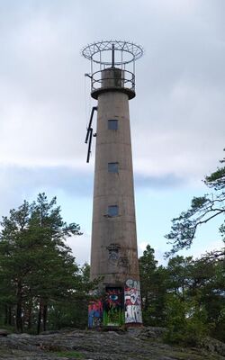
An airway beacon (US) or aerial lighthouse (UK and Europe) was a rotating light assembly mounted atop a tower. These were once used extensively in the United States for visual navigation by airplane pilots along a specified airway corridor. In Europe, they were used to guide aircraft with lighted beacons at night.[1][2]
UK and Europe
United Kingdom
A network of aerial lighthouses was established in the United Kingdom and Europe during the 1920s and 1930s.[3] Use of the lighthouses has declined with the advent of radio navigation aids such as NDB (non-directional beacon), VOR (VHF omnidirectional ranging) and DME (distance measuring equipment). The last operational aerial lighthouse in the United Kingdom is on top of the cupola over the RAF College main hall at RAF Cranwell.[citation needed]
Netherlands
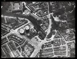
In the Netherlands, gas holders were painted with an arrow pointing north and two letters identifying their location.
United States
Approximately 1,500 airway beacons were constructed to guide pilots from city to city,[4][5] covering 18,000 miles (29,000 km). Today, most of the beacons have been removed, but the State of Montana continues to maintain several as navigation aids in mountainous terrain.[6] One beacon is preserved for historical purposes in Saint Paul, Minnesota[7] at the Indian Mounds Park on a bluff overlooking the Mississippi River.[8] A rotating airway beacon has been in continuous operation at the summit of Rocky Butte in Portland, Oregon since 1929, though it was officially decommissioned during the 1960s. Recently, the beacon at Grants, New Mexico was restored for historic preservation, using original items found at other nearby sites.[9]
A large concrete slab, in the shape of an arrow, was located near the base of each beacon. Many of these arrows remain today, some of which are visible from satellite pictures, even in urban settings.[10]
Light characteristics
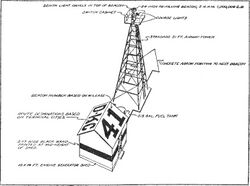
An airway beacon has two distinct light characteristics: A revolving narrow white light beam about 5 degrees wide in azimuth and a set of fixed colored course lights of about 15 degrees width.[11]
White rotating beacon
The rotating beacon 24 inch (610 mm) parabolic mirror and a 110-volt, 1 kilowatt lamp.[11] spinning at 6 rpm, creating a quick one-tenth second flash every ten seconds. In clear weather they could be seen for 40 miles (64 km).[11][12] Montana took steps to modernize their beacons, encasing newer light systems in clear domes.[13]
Red or green course lights
Just below the white beacon, a set of red or green course lights point along each airway route. Red lights denote an airway beacon between landing fields while green denotes a beacon adjacent or upon a landing field.[11] These course lights flash a Morse code letter identifying the beacon to the pilot. Each beacon is identified with a sequential number along the airway, and flash the red or green course lights with the Morse code ID of one of 10 letters: W, U, V, H, R, K, D, B, G or M. The letters represent the digits of 1 through 10 (W = 1, ..., M = 10).[11] The course lights turn on for 0.5 second for a dot, 1.5 second for a dash with a 0.5 second between each dot or dash. A pause of 1.5 seconds separates each letter.[14]
To help remember the letters and their sequence number, pilots memorized the following: "When Undertaking Very Hard Routes, Keep Direction By Good Methods." The beacons are depicted on navigation charts along with their number and Morse code pattern. For example, beacon number 15 would have a code digit of 5 (the units digit), hence the letter R, and Morse code: "dit dah dit" (·−·).[15]
History
Airway beacons in the US were constructed by the Post Office and the Department of Commerce between 1923 and 1933.[12] The Low Frequency Radio Range system began to replace this visual system in 1929.[12] The last visual airway beacon was supposedly shut down in 1973,[12] but a few airway beacons are still operating in Portland, Oregon and Western Montana.[16] Those in Montana are charted on the Great Falls sectional chart.[17] Montana was the last state to officially maintain airway beacons, through the state's Aviation Division. In 2017, the decision was made by Aeronautics Division to discontinue their maintenance of the system, due to the system's obsolete nature and budgetary concerns. The system was to be shut down entirely by December 31st, 2021.[18] In spring of 2018, fourteen of the seventeen beacons were shut down by MDT. The Montana Department of Transportation's Communications Bureau took over care of beacons at St. Regis and Lookout Pass. Six beacons are now in the care of the owners of the land they were erected on, six are in the care of a non-profit, Idaho Aviation Heritage, and four are in the care of local governments.[18] Due to their historical significance in the state, the beacons at Homestake Pass, Canyon Resort, MacDonald Pass, Silver Bow, Spokane, Lookout Pass, St. Regis, Whitetail are in the process of being listed on the National Register of Historic Places. The strawberry Mountain beacon was demolished in the summer of 2021. MDT's Aeronautics Division removed the beacon and donated to the Montana Historical Society.[18]
See also
- Index of aviation articles
- Transcontinental Airway System (United States)
References
- ↑ "The Aerial Lighthouse". Flight. http://www.flightglobal.com/pdfarchive/view/1921/1921%20-%200280.html. Retrieved 2011-11-29.
- ↑ "LIGHTHOUSE FOR AIRSHIPS.; One Already Installed at Spandau for German Army Flights". The New York Times. 5 June 1910. https://www.nytimes.com/1910/06/05/archives/lighthouse-for-airships-one-already-installed-at-spandau-for-german.html.
- ↑ "Aerial Lighthouses". http://www.mycetes.co.uk/a/page16.html.
- ↑ "Airway Beacons List - Eastern US". Roger Barnes. http://surveymarks.planetzhanna.com/airway_beacons_east.shtml.
- ↑ "Airway Beacons List - Western U.S.". Roger Barnes. http://surveymarks.planetzhanna.com/airway_beacons_west.shtml.
- ↑ Savage, Jason. "Airway Beacons". http://jasonsavagephotography.com/tag/airway-beacons/.
- ↑ 7.0 7.1 Cosimini, Greg (1999-07-09). "Indian Mounds Park "Airway" Beacon". University of Minnesota. http://www.tc.umn.edu/~cosim001/beacon.html.
- ↑ Coordinates are 44.94608378510258, -93.05781483650216
- ↑ At least one beacon to be fully restored as a local museum.beacon buildings
- ↑ Aviation Navigation Arrows in Washington County, Utah
- ↑ 11.0 11.1 11.2 11.3 11.4 Wood, Charles. "How it Began". Charles Wood. http://www.navfltsm.addr.com/howitbegan.htm.
- ↑ 12.0 12.1 12.2 12.3 "The Evolution of Airway Lights and Electronic Navigation Aids". U.S. Centennial of Flight Commission. http://www.centennialofflight.gov/essay/Government_Role/navigation/POL13.htm.
- ↑ Spivey, Brenda (1993). Airway Beacons, an Integral Part of Montana's Night VFR Navigational System: Past History, Present Service and Present Value. Embry Riddle Aeronautical University. pp. 21. http://www.eaa517.org/newsletters/AirwayBeacons.pdf. Retrieved 5 April 2012.
- ↑ FAA Advisory Circular Number 170/6850-1. FAA. 1968.
- ↑ Majors, Beverly (July 7, 2009). "Beacon House was part of changes in air transportation". Oak Ridge, TN: OakRidger.com. http://www.oakridger.com/columnists/x135741391/Beacon-House-was-part-of-changes-in-air-transportation.
- ↑ "Airway Beacons". Montana Department of Transportation. http://www.mdt.mt.gov/aviation/beacons.shtml. "Today, Montana is the only state that still utilizes part of this historic network through our rugged western mountains. Division personnel climb and maintain approximately 19 of these beacons on a regular schedule, also providing ownership and ground leases for their operation."
- ↑ Rogan, Michael (2011). Airway Support Officer. "All of our airway beacons and the associated code are listed on any current Great Falls sectional[. . .]"
- ↑ 18.0 18.1 18.2 "Airway Beacons -The End of an Era". Montana Department of Transportation. https://www.mdt.mt.gov/aviation/beacons.aspx.
External links
 |


