Astronomy:T. Mayer (crater)
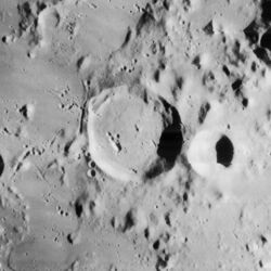
 Lunar Orbiter 4 image | |
| Diameter | 33 km |
|---|---|
| Depth | 2.9 km |
| Colongitude | 29° at sunrise |
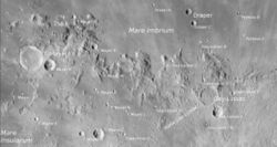
T. Mayer, or Tobias Mayer, is a lunar impact crater that is located at the western end of the Montes Carpatus mountain range along the southern edge of Mare Imbrium. It was named after German astronomer Tobias Mayer.[1] To the west is the Oceanus Procellarum, and to the south is Mare Insularum. The crater is located a couple of hundred kilometers to the northwest of the prominent crater Copernicus.
The name T. Mayer was first given to this crater by Johann Hieronymus Schröter in 1802.
Description
This crater is embedded within a region of rugged ridges and these are attached to the exterior of the rim, most notably along the east and northeast. The rim is generally circular with the bowl-shaped T. Mayer A attached to the exterior along the east-southeast. Within the interior is a level floor marked only by a few craterlets.
Due south of T. Mayer is a cluster of lunar domes, some of which have tiny craterlets at the summits. These domes are the result of volcanic activity.
Satellite craters
By convention these features are identified on lunar maps by placing the letter on the side of the crater midpoint that is closest to T. Mayer.
| T. Mayer | Latitude | Longitude | Diameter |
|---|---|---|---|
| A | 15.3° N | 28.3° W | 16 km |
| B | 15.4° N | 30.9° W | 13 km |
| C | 12.2° N | 26.0° W | 15 km |
| D | 12.2° N | 26.8° W | 8 km |
| E | 16.1° N | 26.2° W | 9 km |
| F | 12.9° N | 28.9° W | 6 km |
| G | 17.3° N | 27.1° W | 7 km |
| H | 11.7° N | 25.5° W | 3 km |
| K | 18.1° N | 27.6° W | 5 km |
| L | 13.2° N | 24.7° W | 4 km |
| M | 14.9° N | 25.6° W | 5 km |
| N | 13.5° N | 25.6° W | 5 km |
| P | 14.0° N | 29.5° W | 35 km |
| R | 11.6° N | 26.4° W | 5 km |
| S | 11.7° N | 28.3° W | 3 km |
| W | 17.5° N | 34.9° W | 34 km |
| Z | 14.2° N | 26.1° W | 4 km |
Lunar Orbiter 4 image of T. Mayer C (right) and T. Mayer D (left)
Lunar Orbiter 4 image of T. Mayer E
References
- ↑ "T. Mayer (crater)". Gazetteer of Planetary Nomenclature. USGS Astrogeology Research Program.
- Andersson, L. E.; Whitaker, E. A. (1982). NASA Catalogue of Lunar Nomenclature. NASA RP-1097.
- Bussey, B.; Spudis, P. (2004). The Clementine Atlas of the Moon. New York: Cambridge University Press. ISBN 978-0-521-81528-4.
- Cocks, Elijah E.; Cocks, Josiah C. (1995). Who's Who on the Moon: A Biographical Dictionary of Lunar Nomenclature. Tudor Publishers. ISBN 978-0-936389-27-1. https://archive.org/details/isbn_9780936389271.
- McDowell, Jonathan (July 15, 2007). "Lunar Nomenclature". Jonathan's Space Report. http://host.planet4589.org/astro/lunar/.
- Menzel, D. H.; Minnaert, M.; Levin, B.; Dollfus, A.; Bell, B. (1971). "Report on Lunar Nomenclature by the Working Group of Commission 17 of the IAU". Space Science Reviews 12 (2): 136–186. doi:10.1007/BF00171763. Bibcode: 1971SSRv...12..136M.
- Moore, Patrick (2001). On the Moon. Sterling Publishing Co.. ISBN 978-0-304-35469-6. https://archive.org/details/patrickmooreonmo00patr.
- Price, Fred W. (1988). The Moon Observer's Handbook. Cambridge University Press. ISBN 978-0-521-33500-3.
- Rükl, Antonín (1990). Atlas of the Moon. Kalmbach Books. ISBN 978-0-913135-17-4.
- Webb, Rev. T. W. (1962). Celestial Objects for Common Telescopes (6th revised ed.). Dover. ISBN 978-0-486-20917-3. https://archive.org/details/celestialobjects00webb.
- Whitaker, Ewen A. (1999). Mapping and Naming the Moon. Cambridge University Press. ISBN 978-0-521-62248-6.
- Wlasuk, Peter T. (2000). Observing the Moon. Springer. ISBN 978-1-85233-193-1.
 |


