Earth:Canada Tornado Alley
The Canadian Tornado Alley(s) is a term describing a tornado-prone region in Canada. In Canada, the word is rarely used when compared to that of the United States where their "Tornado Alley" is largely a media-driven term.[1]
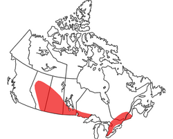
Although the official boundaries of the Canadian Tornado Alleys are not clearly defined, its core extends from Central Alberta through Saskatchewan[2], Southern Manitoba and Northwestern Ontario. A second tornado alley extends from Michigan to Central Ontario and from Central Ontario to Southwestern Quebec. The Canadian Prairies are often considered part of the United States tornado alley.
Canadian Tornado Alley geographical area
Over the years, the location(s) of the Canadian Tornado Alley(s) have been better defined. No complete definition of Canadian Tornado Alley has ever been officially designated and announced by the Environment and Climate Change Canada (ECCC).

According to the National Severe Storms Laboratory (NSSL) FAQ, "Tornado Alley" is a term used by the media as a reference to areas that have higher numbers of tornadoes. [3]
Technically speaking, no province or territory is entirely free of tornadoes; however, they occur more frequently in the Central Canada and Southern Canada, between the Rocky Mountains and the Great Lakes and between the Great Lakes and the St. Lawrence River.
Ontario reports the most tornadoes of any province due to its large population, in addition to its proximity to Canadian Tornado Alley. Saskatchewan, Alberta and Manitoba rank in second place behind Ontario but rank before Quebec. [4]
Canadian Tornado Alley can also be defined as an area reaching from the Rocky Mountains to the St. Lawrence River, excepting Northeastern Ontario.
In the Canadian Tornado Alley in Central/Western Canada, warm, humid air from the United States meets cool, dry air from Northern Canada and the Rocky Mountains. This creates an ideal environment for severe thunderstorms which could produce tornadoes. In the Great Lakes region towards the St. Lawrence River, severe thunderstorms which could produce tornadoes forms from warm, humid air from the United States and cooler air across the Great Lakes, these are triggered alongside lake-breeze fronts. The amount of precipitation in storms around the Great Lakes is normally more than the prairies as the warm temperatures and Great Lakes fuel the storms with heavy precipitation right from the lakes. [5]
See also
- Tornado Alley
- List of tornadoes by province (Canada)
- List of Canadian tornadoes and tornado outbreaks
- List of 21st-century Canadian tornadoes and tornado outbreaks
References
- ↑ "Tornado alley - AMS Glossary" (in en). http://glossary.ametsoc.org/wiki/Tornado_alley.
- ↑ "The new tornado alley - University of Saskatchewan". 2014-01-18. https://web.archive.org/web/20140118195234/http://www.usask.ca/water/news-and-events/news/news43.php.
- ↑ "Tornado FAQ" (in EN-US). https://www.nssl.noaa.gov/education/svrwx101/tornadoes/faq/.
- ↑ "List of tornadoes by province (Canada)" (in en). Wikipedia. 2018-05-06. https://en.wikipedia.org/w/index.php?title=List_of_tornadoes_by_province_(Canada)&oldid=839959107.
- ↑ "Tornado Alley" (in en). Wikipedia. 2018-04-28. https://en.wikipedia.org/w/index.php?title=Tornado_Alley&oldid=838709423.

