Earth:Carlin Unconformity


The Carlin Unconformity or Carlin Trend is a geologic feature in northeastern Nevada which represents a period of erosion or non-deposition likely associated with a collision between a tectonic crustal block called a terrane and the North American Plate. The collision occurred during the Mississippian Period, about 350 million years before present. The collision is associated with the Antler Orogeny.[1]
The collision induced higher crustal temperatures and pressures which produced numerous hot springs along the suture zone. Several episodes of subsurface magmatism are known to have occurred subsequent to the collision, associated with tectonic forces affecting the entire Basin and Range Province. During each of these episodes, and particularly during the Eocene epoch, hot springs brought dissolved minerals toward the surface, precipitating them out along fissures.[2] Among these minerals were gold and silver.
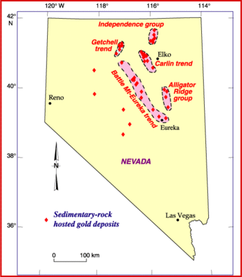
The Carlin Gold trend is one of the world's richest gold mining districts. It is a belt of gold deposits, primarily in Paleozoic limy sediments, that is about 5 mi (8.0 km) wide and 40 mi (64 km) long, extending in a north-northwest direction through the town of Carlin, Nevada. Gold was first discovered in the area in the 1870s, but there was little production until 1909, and only about 22,000 ounces was produced through 1964. By 2008, mines in the Carlin Trend had produced over 70 million ounces of gold, worth around $85 billion at 2010 prices.[3]
See also
- Carlin–type gold deposit
- Gold mining in Nevada
- John Livermore
- Ralph J. Roberts
References
- ↑ Blakely, Ron. "Geologic History of Western US". http://jan.ucc.nau.edu/~rcb7/Text_WUS.html. Retrieved 2010-06-06.
- ↑ Ressel, Michael W.; Henry, Christopher D. (March 2006). "Igneous Geology of the Carlin Trend, Nevada: Development of the Eocene Plutonic Complex and Significance for Carlin-Type Gold Deposits". Economic Geology 101 (2): 347–383. doi:10.2113/gsecongeo.101.2.347. Bibcode: 2006EcGeo.101..347R. http://econgeol.geoscienceworld.org/cgi/content/abstract/101/2/347.
- ↑ "Update on Production and Exploration Activity in Nevada - 2009". Nevada Bureau of Mines and Geology. Archived from the original on 2012-03-26. https://web.archive.org/web/20120326095321/http://www.nbmg.unr.edu/_docs/Presentations/NWMAupdate09.pdf.
Further reading
- McPhee, John (1981). Basin and range. New York: Farrar, Straus and Giroux. ISBN 0-374-10914-1. OCLC 7173053. https://www.worldcat.org/oclc/7173053.
- McPhee, John (1993). Assembling California (First ed.). New York: Farrar, Straus and Giroux. ISBN 0-374-10645-2. OCLC 26809557. https://www.worldcat.org/oclc/26809557.
- Coope, J. Alan (1991). "Carlin trend exploration history: Discovery of the Carlin deposit" (pdf). Nevada Bureau of Mines and Geology Publications. https://data.nbmg.unr.edu/public/freedownloads/sp/sp013.zip.
- Newmont's reserve history on the Carlin Trend, 1965 - 2001 by Dean G. Heitt, Newmont Mining Corporation
- Teal, Lewis; Jackson, Mac (1997-01-01). "Geologic Overview of the Carlin Trend Gold Deposits and Descriptions of Recent Deep Discoveries" (in en). Carlin-Type Gold Deposits Field Conference. Society of Economic Geologists Guidebook Series. 25. Society of Economic Geologists. doi:10.5382/GB.28. ISBN 9781934969816. https://pubs.geoscienceworld.org/books/book/1841/chapter/107706193/Geologic-Overview-of-the-Carlin-Trend-Gold.
 |
