Earth:Cerro Pantoja
From HandWiki
Short description: Mountain in Argentina
| Cerro Pantojo | |
|---|---|
 | |
| Highest point | |
| Elevation | 2,024 m (6,640 ft) |
| Coordinates | [ ⚑ ] : 40°46′0″S 71°57′0″W / 40.766667°S 71.95°W |
| Geography | |
| Location | Argentina /Chile |
| Parent range | Andes |
| Geology | |
| Mountain type | Stratovolcano |
| Last eruption | Unknown |
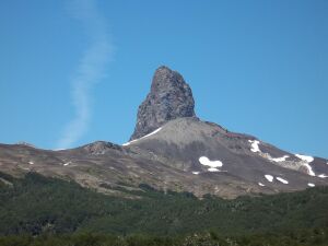
Cerro Pantojo is an extinct basaltic stratovolcano on the border of Argentina and Chile . It lies immediately south of Cardenal Antonio Samoré Pass and its characteristic spire-shaped summit is an eroded volcanic plug. It also has flank lava flows.
See also
- List of volcanoes in Chile
- List of volcanoes in Argentina
References
- "Cerro Pantojo". Smithsonian Institution. https://volcano.si.edu/volcano.cfm?vnum=357152.
- Lara, Luis; Rodríguez, Carolina; Moreno, Hugo; Pérez de Arce, Carlos (July 2001). "Geocronología K-Ar y geoquímica del volcanismo plioceno superior-pleistoceno de los Andes del sur (39-42°S)". Revista Geológica de Chile 28 (1). doi:10.4067/S0716-02082001000100004.
 |

