Earth:Chatyr-Kul
| Lake Chatyr-Kul | |
|---|---|
 | |
 Lake Chatyr-Kul  Lake Chatyr-Kul | |
| Location | Tian Shan mountains, Naryn Province |
| Coordinates | [ ⚑ ] : 40°37′N 75°18′E / 40.617°N 75.3°E |
| Type | Endorheic Mountain lake |
| Native name | Chatyrkol (Kyrgyz) |
| rivers, streams, precipitation">Primary inflows | Glaciers |
| rivers, streams, evaporation">Primary outflows | Evaporation |
| Catchment area | 1,050 km2 (410 sq mi) |
| Basin countries | Kyrgyzstan |
| Designation | Ramsar site |
| Max. length | 23 km (14 mi) |
| Max. width | 10 km (6.2 mi) |
| Surface area | 181 km2 (70 sq mi) |
| Max. depth | 16.5 m (54 ft) |
| Water volume | 0.62 km3 (0.15 cu mi) |
| Shore length1 | 58 km (36 mi) |
| Surface elevation | 3,530 m (11,580 ft) |
| Islands | none |
| Settlements | none |
| Official name | Chatyr Kul |
| Designated | 8 November 2005 |
| Reference no. | 1588[1] |
| 1 Shore length is not a well-defined measure. | |
Chatyr-Kul (also Chatyr Köl, Chatyrkol, Kyrgyz: Чатыркөл) is an endorheic alpine lake in the Tian Shan mountains in At-Bashi District of Naryn Province, Kyrgyzstan; it lies in the lower part of Chatyr-Kul Depression near the Torugart Pass border crossing into China . The name of the lake means “Celestial Lake” in Kyrgyz (literally "Roof Lake"). The lake and 2 km buffer zone around it is part of the Karatal-Japyryk State Nature Reserve. The lake is a Ramsar site of globally significant biodiversity (Ramsar Site RDB Code 2KG002).
Climate
The mean annual temperature in the lake basin is −5.6 °C (21.9 °F), with mean temperature of −22 °C (−8 °F) in January, and 7.1 °C (44.8 °F) in July. The maximum temperature in summer is 24 °C (75 °F), and the minimum one in winter is −50 °C (−58 °F). Some 88-90% of the lake basin's 208–269 mm of annual precipitation falls in summer. From October to end of April the lake surface freezes, the ice becoming as much as 0.25-1.5 m thick.[2][3]
Hydrology
The water of Chatyr Kul Lake is yellowish-green with water transparency of up to 4 metres (13 ft). The mineralization of the lake ranges from 0.5 to 1.0 milligrams per liter (chloride, hydrocarbonate, sodium and magnesium type of mineralization). The salinity of the lake is 2 ppt. Mineral sources in the south part of the lake have mineralization of from 5 to 7 grams (0.18 to 0.25 oz) per liter and pH = 5,8-6,0. Flow rate is 1,866 m3 (65,900 cu ft) in winter and 3,629 cubic metres (128,200 cu ft) during summer.[4] 41 small streams debouches into the lake, of those 21 originate in Torugart Range and 20 - in Atbashi Range.[5]
Negative water balance of the lake over the last decades causes the decline in the lake level.
Gallery
-
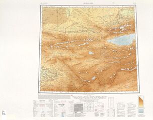 Map of the region including the Ozero Chatyr-Kul' (AMS, 1948)
 -
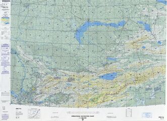 Map of the region including the Ozero Chatyr-kel' (DMA, 1985)
_-_panoramio.jpg)

References
- ↑ "Chatyr Kul". https://rsis.ramsar.org/ris/1588.
- ↑ (in ru). Bishkek: Academy of Sciences of Kyrgyz SSR. 1987. pp. 156.
- ↑ (in ru). Bishkek: Chief Editorial Board of Kyrgyz Soviet Encyclopedia. 1994. pp. 512. ISBN 5-89750-009-6.
- ↑ "Information Sheet on Ramsar Wetlands". http://www.wetlands.org/reports/ris/2KG002_RIS_E%202005.pdf.[yes|permanent dead link|dead link}}]
- ↑ (in ky) Кыргызстандын географиясы.. Bishkek: Chief Editorial Board of Kyrgyz National Encyclopedia. 2004. pp. 718. ISBN 9967-14-006-2.
 |
