Earth:Cheltenham Badlands
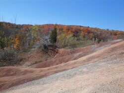
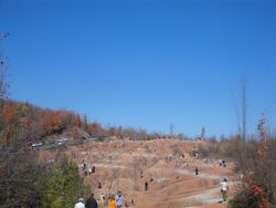
Cheltenham Badlands is a small example of badlands formation in Caledon, Ontario.
The site is located on the south east side of Olde Base Line Road, between Creditview and Chinguacousy Roads, west of Highway 10 in Caledon, and features exposed and eroded Queenston Shale. The formation is located along the Niagara Escarpment.
History
The formation was exposed by poor farming practices in the 1930s that led to soil erosion and exposed the underlying shale.[1]
At one point in time, the Cheltenham Badlands were occupied by a large river. The hills signify the riverbed and as you follow the trail, you begin to see the river history of the badlands. Thousands of years ago, this lake dried out resulting in today's version of the Cheltenham badlands.
The formation is mostly red in colour due to iron oxide deposits[2] with some faint green streaks due to ground water percolation changing the red iron oxide into green iron oxide.[3]
Conservation
Once farmland, it was purchased by the Ontario Heritage Foundation in 2000 and managed by the Bruce Trail Association.[4] Development is also restricted on the site by the Niagara Escarpment Commission
The formation is located along the Niagara Escarpment and Bruce Trail and is part of or near various geographically important areas of Southern Ontario:
- Ontario Greenbelt
- just outside Oak Ridges Moraine
Located within the Niagara Escarpment, the site is by default part of the local UNESCO World Biosphere Reserve.
There are concerns by conservationists that increased visitors to the area will cause damage to the formation and suggest closure or restriction of access to the site.[5] Trails leading from the site are now closed.
Parking is limited to a small area on the south side of Olde Base Line Road with restrictions beyond and on the other side of the road. You will also find the Bruce Trail in the nearby forest. There are many strange rocks and minerals on the Red Clay Hills. On May 6, 2015, the Ontario Heritage Trust announced that the Badlands site would be closed to visitors for several years at the end of May, due to the excessive number of visitors who were walking on the formations, causing damage that accelerated the erosion.[6]
As of July 2015 the Badlands have been fenced off and closed to visitors; marked No Trespassing and the parking areas have been changed to no parking - tow away zones. The closure is indicated as temporary as a public consultation and master plan study is underway.
The area will finally be open (legally and ethically) as of Sept 22, 2018. A new parking area has been created to manage traffic concerns.
See also
- Bruce Trail
- Niagara Escarpment
References
- ↑ "Cheltenham Badlands". 2 May 2015. http://www.day-trips.ca/content/cheltenham-badlands.
- ↑ "Cheltenham Badlands Trail - Ontario Trails Council". http://www.ontariotrails.on.ca/trails-a-z/cheltenham-hills/.
- ↑ "Archived copy". Archived from the original on 2010-11-30. https://web.archive.org/web/20101130134858/http://torontohiking.com/html/l16badlnd.html. Retrieved 2010-01-02. Loop Hike L16 Cheltenham Badlands
- ↑ "Cheltenham Badlands - Sun, Aug 30 2009". http://www.torontooutdoorclub.com/events/details.asp?eventid=1890.
- ↑ [1][|permanent dead link|dead link}}]
- ↑ "Ontario's Cheltenham Badlands to close to halt tourist damage". 6 May 2015. http://www.ctvnews.ca/lifestyle/ontario-s-cheltenham-badlands-to-close-to-halt-tourist-damage-1.2362238.
[ ⚑ ] 43°46′25″N 79°56′40″W / 43.77361°N 79.94444°W


