Earth:Crooked Creek crater
From HandWiki
Short description: Impact crater in Missouri
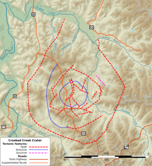
 Faults and other tectonic structures related to the Crooked Creek crater on a shaded relief map | |
| Impact crater/structure | |
|---|---|
| Confidence | Confirmed |
| Diameter | 4.3 mi (7 km) |
| Age | 320 ± 80 Ma (Mississippian) |
| Exposed | Yes |
| Drilled | No |
| Bolide type | see 38th parallel structures |
| Location | |
| Coordinates | [ ⚑ ] : 37°50′N 91°23′W / 37.833°N 91.383°W[1] |
| Country | United States |
| State | Missouri |
| District | Crawford County |
| Lua error in Module:Location_map at line 522: Unable to find the specified location map definition: "Module:Location map/data/Missouri" does not exist. | |
| Topo map | USGS Cook Station |
Crooked Creek is an impact crater in Crawford County, Missouri, United States .
It is 4.3 miles (7 km) in diameter and the age is estimated to be 320 ± 80 million years (Mississippian). The crater is exposed to the surface.[1]
This is one of the 38th parallel structures, a series of circular depressions stretching across the central United States, thought to possibly be the result of a serial impact.
See also
- Decaturville crater
- Weaubleau structure
References
 |


