Earth:Geography of Gozo
Template:Infobox country geographyThe geography of Gozo, is dominated by water as it is the second largest island in the Maltese archipelago[1] and is made up out of limestone. There are several islands which fall under Gozitan jurisdiction and thus are additions to the overarching Maltese archipelago. The main island of Gozo is located 7 kilometres (4.3 mi) northwest of the main island of Malta.[2] It is mostly known for its multitude of low-lying hills.[3] The highest point in Gozo is Ta' Dbiegi hill, which falls under the San Lawrenz local council.[4] The island of Comino, which is also the third largest island in Malta, falls under Gozo.[5]
Extreme Points of Gozo
| Reqqa Point (northernmost point)[6] | ||
| San Dimitri Point (westernmost point)[7] | Ta' Dbiegi hill (highest altitude)[4] | Ras il-Qala (easternmost point on contiguous Gozo)[8] |
|---|---|---|
| Newwiela Point (southernmost point on contiguous Gozo)[9] | ||
| Lantern Point (southernmost point on non-contiguous Gozo)[10] | Sultan Rock (easternmost point on non-contiguous Gozo)[11] |
Lantern Point and Sultan Rock are both found on Comino.[10][11]
San Dimitri Point and Reqqa Point are the westernmost and northernmost points of the entirety of the Maltese islands.[6][7]
The lowest altitude of Gozo is obviously 0 metres (0 ft) above sea level as the island is surrounded by the Mediterranean Sea.[12][1]
Index of hills in Gozo
| Corresponding Villages (If Any) | Highest Elevation | Image | References | |
|---|---|---|---|---|
| Iz-Zebbug | Iz-Zebbug | 165 metres (541 ft) | 
|
[13][14][15] |
| Ta' Dabrani | 141 metres (463 ft) | [16] | ||
| Ta' Kuljat | 166 metres (545 ft) | [17][18] | ||
| Ix-Xaghra | Xaghra | 143 metres (469 ft) | 
|
[19] |
| In-Nuffara | 144 metres (472 ft) | 
|
[20] | |
| In-Nadur | Nadur, Qala | 162 metres (531 ft) | 
|
[21] |
| Ta' Sannat / Ta' Cenc | Sannat | 171 metres (561 ft) | .jpg)
|
[22] |
| Kercem | Kercem | 159 metres (522 ft) | 
|
[23][24] |
| Ta' Dbiegi | San Lawrenz | 190 metres (620 ft) | 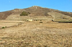
|
[25] |
| Ta' Ghammar | Għarb | 186 metres (610 ft) |  |
[26][25] |
| Il-Giordan | Għasri | 163 metres (535 ft) | 
|
[27] |
References
- ↑ 1.0 1.1 "State of the Environment Reports" (in en-US). https://era.org.mt/topic/soer/.
- ↑ Evans, G. H. (1900) (in en). Guide to Malta and Gozo. W. Watson. pp. 35. https://books.google.com/books?id=k3w7AQAAIAAJ&q=distance+between+gozo+and+malta.
- ↑ "Gozo and its 31 hills" (in en-gb). https://timesofmalta.com/articles/view/gozo-and-its-31-hills.671387.
- ↑ 4.0 4.1 "Gozo history & geography" (in en). https://www.responsibletravel.com/holidays/gozo/travel-guide/gozo-history-geography.
- ↑ "About Comino" (in en-US). https://www.visitgozo.com/about-comino/.
- ↑ 6.0 6.1 "Reqqa Point" (in en-US). https://www.visitgozo.com/experience-gozo/diving/reqqa-point/.
- ↑ 7.0 7.1 "San Dimitri" (in en-US). https://www.visitgozo.com/where-to-go-in-gozo/churches-and-chapels/san-dimitri/.
- ↑ "RAS IL-QALA, Malta, Dive Site Information" (in en). https://www.divers-guide.com/en/ras-il-qala.
- ↑ ATLAM (2019-02-27). "Newwiela Point Gozo" (in en-US). http://maltasac.org/newwiela-point-gozo/.
- ↑ 10.0 10.1 "Lantern Point, South east Comino". https://www.malta.com/en/attraction/diving/diving-site/comino/lantern-point.
- ↑ 11.0 11.1 "SULTAN ROCK, Malta, Dive Site Information" (in en). https://www.divers-guide.com/en/sultan-rock.
- ↑ "The island and the sea: Malta's maritime tradition" (in en). https://www.guidememalta.com/en/the-island-and-the-sea-malta-s-maritime-tradition.
- ↑ "Towns & Villages of Gozo". http://www.discovergozo.com.mt/towns-and-villages/zebbug.
- ↑ "Żebbuġ at Gozo Diocese". http://gozodiocese.org/churches/parishes/zebbug/.
- ↑ "Iz-Zebbug Gozo Local Council | Kunsill Lokali - Culture & History Zebbug Gozo". http://www.zebbuggozo.com/history-zebbug.php.
- ↑ "Ta' Dabrani hill, Iż-Żebbuġ, Malta". https://mt.geoview.info/ta_dabrani,2562466.
- ↑ Sagona, Claudia (2015-08-25) (in en). The Archaeology of Malta. Cambridge University Press. ISBN 978-1-107-00669-0. https://books.google.com/books?id=qR5TCgAAQBAJ&dq=ta&pg=PA325.
- ↑ Dawson, Helen (July 2016) (in en). Mediterranean Voyages: The Archaeology of Island Colonisation and Abandonment. Routledge. ISBN 978-1-315-42476-7. https://books.google.com/books?id=wWWTDAAAQBAJ&dq=ta&pg=PA110.
- ↑ Proud, Edward Wilfrid Baxby (1999). The postal history of Malta. Heathfield: Proud-Bailey. ISBN 1-872465-31-5. OCLC 43582096. https://www.worldcat.org/oclc/43582096.
- ↑ "In-Nuffara" (in en). https://www.guidememalta.com/en/attraction/in-nuffara.
- ↑ "NadurParish.com – Basilica of St. Peter and St. Paul in Gozo, Malta" (in en-US). https://www.nadurparish.com/.
- ↑ "Ta' Cenc Cliffs" (in en). https://www.guidememalta.com/en/attraction/ta-cenc-cliffs.
- ↑ "Ta' Kerċem - Where to go in Gozo | Towns & Villages" (in en-US). https://www.visitgozo.com/where-to-go-in-gozo/towns-villages/ta-kercem/.
- ↑ "Gozo.com Explore Gozo - Kercem". http://www.gozo.com/explore/towns_villages/kercem.php.
- ↑ 25.0 25.1 Rix, Juliet (2013) (in en). Malta and Gozo. Bradt Travel Guides. pp. 296. ISBN 978-1-84162-452-5. https://books.google.com/books?id=FzeTVgOkeRQC&dq=ta+dbiegi&pg=PA334.
- ↑ Rix, Juliet (2010) (in en). Malta. Bradt Travel Guides. ISBN 978-1-84162-312-2. https://books.google.com/books?id=Hj7MN2TLfdwC&dq=Ta%27+Ghammar&pg=PA312.
- ↑ Malta (1872) (in en). Laws Made by the Legislature During the Year .... Government Press. pp. 45. https://books.google.com/books?id=LnUZAAAAYAAJ&dq=giordan+gozo&pg=PA45.
 |

