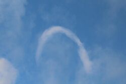
Earth:Horseshoe cloud
From HandWiki

A horseshoe cloud is a relatively uncommon meteorological phenomenon[1] which manifests as a cloud in the shape of a horseshoe or inverted letter "U".[1][2]
They occur when a horseshoe vortex deforms a cumulus cloud.[2] The clouds are relatively short-lived[2] and is the last stage before one dissipates.[3] Horseshoe vortex clouds are a form of "fair-weather" funnel cloud and are similar to the shear funnel type of funnel cloud.[citation needed]
A March 2018 instance was explained by the United States National Weather Service:[4][5]
These clouds do not occur often because all the needed conditions rarely occur together.[3]
References
- ↑ 1.0 1.1 "Horseshoe Vortex Cloud (February 07)". Cloud Appreciation Society. January 31, 2007. https://cloudappreciationsociety.org/horseshoe-vortex-cloud-february-07/. Retrieved March 12, 2018.
- ↑ 2.0 2.1 2.2 "An incredibly rare 'horseshoe cloud' was spotted in Nevada and it kept the meme-makers busy". March 12, 2018. https://www.independent.ie/world-news/and-finally/an-incredibly-rare-horseshoe-cloud-was-spotted-in-nevada-and-it-kept-the-mememakers-busy-36691086.html. Retrieved March 12, 2018.
- ↑ 3.0 3.1 Baer, Stephanie K. (March 10, 2018). "People On Twitter Are Freaking Out Over This Rare Type Of Cloud" (in en). https://www.buzzfeednews.com/article/skbaer/horseshoe-cloud-staple-mustache.
- ↑ @NWSElko. "As the updraft pushes flattish cumulus clouds up & a horizontal vortex develops from differential updraft speeds...". https://twitter.com/NWSElko/status/972173128800628736. Missing or empty |date= (help)
- ↑ @NWSElko. "As the vortex climbs, it's caught in the faster horizontal winds aloft,& the middle part of the vortex catches the faster speeds with the ends being slower.". https://twitter.com/NWSElko/status/972173174422036490. Missing or empty |date= (help)
 |
