Earth:Ignatievka Cave
Игнатьевская пещера | |
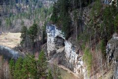
 Sim river and cave entry | |
| Alternative name | Yamazy-Tash |
|---|---|
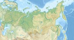
| Location | on the banks of the Sim River, Sim, Chelyabinsk Oblast |
| Region | southern Ural mountains |
| Coordinates | [ ⚑ ] : 54°53′57″N 57°46′50″E / 54.89917°N 57.78056°E |
| Type | limestone cave |
| History | |
| Periods | Paleolithic |
Ignatievka Cave (Ignateva cave, Ignatievskaya cave, Russian: Игнатьевская пещера, also known as Yamazy-Tash) is a large limestone cave on the banks of the Sim River, a tributary of the Belaya river in the southern Ural Mountains of Russia .[1][2] In 1980 a parietal wall painting of a female figure was discovered. The twenty-eight red dots between her legs are believed to represent the female menstrual cycle.[3][4]
The cave also contains microliths, remains of animals and more cave paintings, as well as a stratum of Iron Age settlement.[5] Although some sources associate the paintings to the Upper Paleolithic,[5][6] the age of the drawings continues to be debated. The radiocarbon dating of the charcoal drawings has resulted in more recent numbers, between 6,000 and 8,000 years ago. The attempt to date the red pigment of the female figure yielded no result.[7] In this respect, the age of the drawings remains unclear so far.
Ignateva Cave can be freely visited although it is best to travel via the small village of Serpiyevka (ru), which is off the main road past Sim, Chelyabinsk Oblast, heading eastwards, about 15 km (9.3 mi). The track to the cave is very rough and has not been improved for years. The cave mouth is about 18 m (59 ft) above the small river backwater and reached by a metal ladder. On entering the cave visitors must stoop low as the ceiling lowers quickly to about 1 m (3.3 ft) in height, and then it increases again to 2 m (6.6 ft) or more. Part of the inner cave can only be reached by crawling through a very narrow space about 0.5 m (1.6 ft) in height but this provides views of some of the better red ochre markings. The local guide from Serpiyevka noted that the cave was not lived in (there were no fire markings), but hypothesized that it was a sacred site mainly used for religious ceremonies and adulthood rites from the markings.
The Kapova cave is located some 120 km (75 mi) from the Ignatievka cave.
-
Alternative view of cave entrance
-
Looking out from the cave
-
Ochre figure of a person
References
- ↑ Bahn, Paul G. (1993), Collins Dictionary of Archaeology, ABC-CLIO, p. 224, ISBN 0-87436-744-1, https://archive.org/details/collinsdictionar0000unse_d5k1/page/224.
- ↑ Shirokov, Vladimir (2002), Review of the Ural cave and rock art, The Northern Archaeological Congress, http://www.northcongress.ural.ru/index/en/arh/public?r_id=504
- ↑ Rudgley, Richard (1998), Lost Civilisations of the Stone Age, Century, p. 196, ISBN 0-7126-7758-5.
- ↑ Blackledge, Catherine (2004), The Story of V: A Natural History of Female Sexuality, Rutgers University Press, p. 37, ISBN 0-8135-3455-0, https://archive.org/details/storyofv00cath/page/37.
- ↑ 5.0 5.1 Kipfer, Barbara Ann (2000), Encyclopedic Dictionary of Archaeology, Springer-Verlag, p. 250, ISBN 0-306-46158-7.
- ↑ Dublyansky, Yuri; Shirokov, Vladimir; Moseley, Gina E.; Kosintsev, Pavel A.; Edwards, R. Lawrence; Spötl, Christoph (May 2021). "230 Th dating of flowstone from Ignatievskaya Cave, Russia: Age constraints of rock art and paleoclimate inferences" (in en). Geoarchaeology 36 (3): 532–545. doi:10.1002/gea.21851. ISSN 0883-6353. PMID 33883826.
- ↑ Steelman, K. L.; Rowe, M. W.; Shirokov, V. N.; Southon, J. R. (2002), "Radiocarbon dates for pictographs in Ignatievskaya Cave, Russia: Holocene age for supposed Pleistocene fauna", Antiquity 76 (292): 341–348, doi:10.1017/S0003598X00090426, http://www.antiquity.ac.uk/ant/076/Ant0760341.htm.
- Bagautdinov Airat Maratovich. Deciphering the signs and drawings of the Ignatius Cave (Yazma-Tash). Star map. Life and death. Ufa. 2023. - 47 p. ISBN 978-5-00177-668-0


