Earth:Mount Gharat
| Mount Gharat (Mount Garet) | |
|---|---|
 Mount Gharat and Lake Letas | |
| Highest point | |
| Elevation | 797 m (2,615 ft) [1] |
| Prominence | 797 m (2,615 ft) |
| Coordinates | [ ⚑ ] : 14°16′S 167°30′E / 14.27°S 167.5°E [1] |
| Geography | |
 Mt Garet, in the middle of Gaua island
| |
| Location | Gaua, Banks Islands, Vanuatu |
| Geology | |
| Mountain type | Somma-Stratovolcano |
| Last eruption | 2011[1] |
Mount Gharat or Mount Garet (797 m), a somma volcano, is the highest peak on the volcanic island of Gaua of the Banks Islands in northern Vanuatu.
Geography
The peak is located at the centre of the island, is volcanically active and is surrounded by Lake Letas on all sides except the southwest.
-
 Eruption of Mt Garet in Sept 2010.
 -
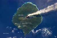 2013 satellite picture of Mt Garet during eruption


Name
The volcano has slightly different names, depending on which of the local languages is being considered. It is known as Garet [ɣaˈrɛt] in Nume, Grāt [ɣraːt] in Dorig, Gerät [ɣɛˈrɛ͡at] in Koro, Gäräs [ɣæˈræs] in Lakon. The spelling Gharat found sometimes on maps is an attempt at transcribing Mota or Olrat Garat [ɣarat].
All these names come from a Proto-Torres-Banks form *ɣarati, whose literal meaning is “itching, burning” ‒ perhaps in relation to the volcano's toxic fumes.
References
 |  |
