Earth:Mount Robert Barron
| Mount Robert Barron | |
|---|---|
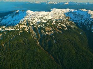
 Mount Robert Barron, northwest aspect | |
| Highest point | |
| Elevation | 3,475 ft (1,059 m) [1] |
| Prominence | 3,425 ft (1,044 m) [1] |
| Isolation | 11.67 mi (18.78 km) [1] |
| Coordinates | [ ⚑ ] : 58°13′35″N 134°50′15″W / 58.22639°N 134.8375°W [2] |
| Geography | |
| Location | Tongass National Forest Hoonah-Angoon Alaska, United States |
| Parent range | Alexander Archipelago[2] |
| Topo map | USGS Juneau A-3 |
| Climbing | |
| Easiest route | 7-mile unmaintained trail[3] |
Mount Robert Barron is a 3,475-foot (1,059 m) elevation mountain summit located on Admiralty Island in the Alexander Archipelago, in the U.S. state of Alaska. It is the highest point on the island's Mansfield Peninsula, and is situated 16 mi (26 km) west-southwest of Juneau, on land managed by Tongass National Forest. Although modest in elevation, relief is significant since the peak rises up from tidewater at Funter Bay on Lynn Canal in less than two miles, and from Stephens Passage to the east in less than three miles.
History
This geographic feature was named by the United States Coast and Geodetic Survey in 1919 for Robert James Barron (1896–1917), son of James T. Barron, both of whom were instrumental in developing the Funter Bay region.[4] Robert enlisted with the Aviation Service on June 2, 1917; and, on August 22, 1917, sacrificed his life in an effort to rescue two imperiled fellow pilots when he drowned in the Delaware River as the airplane he was flying fell into the water.[2] The War Department honored his heroism by naming Barron Field in Texas after him.[5] The mountain's name was officially adopted in 1919 by the U.S. Board on Geographic Names.
Climate
Based on the Köppen climate classification, Mount Robert Barron has a subarctic climate with cold, snowy winters, and mild summers.[6] Weather systems coming off the Gulf of Alaska are forced upwards by the mountains (orographic lift), causing heavy precipitation in the form of rainfall and snowfall. Temperatures can drop below −20 °C with wind chill factors below −30 °C. The month of July offers the most favorable weather for viewing or climbing Mount Robert Barron.
See also
- List of mountain peaks of Alaska
- Geography of Alaska
References
- ↑ 1.0 1.1 1.2 "Robert Barron, Mount - 3,475' Alaska". https://listsofjohn.com/peak/187591. Retrieved 2020-04-12.
- ↑ 2.0 2.1 2.2 "Mount Robert Barron". United States Geological Survey. https://geonames.usgs.gov/apex/f?p=gnispq:3:::NO::P3_FID:1414333.
- ↑ Alaska Wilderness Milepost, 1990, page 51
- ↑ Dictionary of Alaska Place Names, Donald J. Orth author, United States Government Printing Office (1967), page 808
- ↑ Location of U.S. Aviation Fields, The New York Times, 21 July 1918
- ↑ Peel, M. C.; Finlayson, B. L.; McMahon, T. A. (2007). "Updated world map of the Köppen−Geiger climate classification". Hydrol. Earth Syst. Sci. 11. ISSN 1027-5606.
External links
- Weather forecast: Mount Robert Barron
- Biography of Robert Barron
- Flying Around Mt. Robert Barron: YouTube
 |


