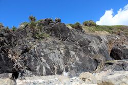
Earth:Neranleigh-Fernvale Beds
From HandWiki
Short description: Geological formation in the north eastern Queensland
| Neranleigh-Fernvale Beds Stratigraphic range: Late Devonian-Early Carboniferous ~365–332 Ma | |
|---|---|
 Cabarita Beach, Australia | |
| Type | Geological formation |
| Thickness | 2,500–3,500 m (8,200–11,500 ft) |
| Lithology | |
| Primary | Sandstone |
| Other | Siltstone, chert, basalt |
| Location | |
| Coordinates | [ ⚑ ] : 28°20′03″S 153°34′26″E / 28.334132°S 153.573864°E |
| Region | New South Wales & Queensland |
| Country | |
| Type section | |
| Named for | Neranwood & Beenleigh |
| Named by | Bryan and Jones 1950, renamed by Korsch, R.J. & Harrington, H.J., 1981 |
| Year defined | 1950 |
| Region | New South Wales & Queensland |
| Country | Australia |
| Lua error in Module:Location_map/multi at line 27: Unable to find the specified location map definition: "Module:Location map/data/Queensland" does not exist. | |
The Neranleigh-Fernvale beds is a geologic formation in the north east of New South Wales and Queensland, Australia . This formation was created in the Late Devonian to the Early Carboniferous, of a thickness up to 3,500 metres (11,500 ft).
Description
This formation contains a heterogeneous succession of sandstone. Either derived from volcanic action, or locally oolitic. Other constituents include siltstone, chert and minor mafic volcanics including pillow basalt. Conglomerate and jasper, with low metamorphosed greenschist are also present. Basaltic volcanics are interbedded with the Neranleigh-Fernvale sediments. Fossils are rarely encountered.[1][2][3]
See also
- Clarence-Moreton Basin
References
- ↑ "Neranleigh-Fernvale beds". Geo Science Australia. Australian Government. https://asud.ga.gov.au/search-stratigraphic-units/results/14021.
- ↑ Lohe, Eric Manfred. "The Neranleigh-Fernvale beds of southeastern Queensland : petrology, sedimentology, structure metamorphism, and tectonic evolution". The Neranleigh-Fernvale beds of southeastern Queensland : petrology, sedimentology, structure metamorphism, and tectonic evolution. University of Queensland. https://espace.library.uq.edu.au/view/UQ:329812.
- ↑ Henley, H.F., Brown, R.E., Brownlow, J.W., Barnes, R.G., Stroud, W.J., 2001, Grafton-Maclean 1:250 000 Metallogenic Map SH56-6, 7, Geological Survey of New South Wales, Sydney, Map, Map Legend
 |

