Earth:Pajarito Formation
| Pajarito Formation Stratigraphic range: Albian ~112–100 Ma | |
|---|---|
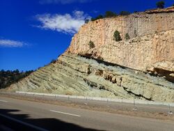
 Pajarito Formation beds (lower left) in road cut on I-25, Romeroville, New Mexico, USA | |
| Type | Formation |
| Unit of | Dakota Group |
| Underlies | Romeroville Sandstone, Graneros Shale. Dakota Sandstone |
| Overlies | Mesa Rica Sandstone |
| Thickness | up to 20 m (66 ft)[1] |
| Lithology | |
| Primary | Shale |
| Other | Sandstone, siltstone |
| Location | |
| Coordinates | [ ⚑ ] 35°04′43″N 103°47′59″W / 35.0787°N 103.7998°W |
| Region | New Mexico, west Texas |
| Country | |
| Type section | |
| Named by | Dobrovolny, Summerson, and Bates |
| Year defined | 1947 |
The Pajarito Formation is a geologic formation in eastern New Mexico and west Texas. It preserves fossils dating back to the Albian Age of the Cretaceous Period.[2]
Description
In Quay County, New Mexico, where the unit was first described, it consists of poorly cemented brown sandstone and gray shale and is 50–60 feet (15–18 m) thick. It overlies the Mesa Rica Formation and underlies the Graneros Shale, and is assigned to the Purgatoire Group.[2] Further north, in the valley of the Dry Cimarron, the formation consists of medium gray shale and is 10–20 meters (33–66 ft) thick.[3]
The formation was deposited in a shallow marine.[3] or delta plain[4] environment. This marked the onset of the Greenhorn marine cycle in northeastern New Mexico.[5]
Fossils
The formation contains abundant fossil remains of the oyster Ostrea quadriplicata, a fossil of early Cretaceous age.
Dinosaur trackways are preserved in the sandstone and silty sandstone horizons of the formation, which is part of the "dinosaur freeway" megatracksite of New Mexico, Colorado, and Oklahoma. Dinosaur tracks were discovered in the Pajarito Formation and underlying Mesa Rica Formation at the spillway of Clayton Lake State Park in 1982. The Clayton Lake trackways are unusual in showing trail dragging traces. The trackways here are accessible by a trail with interpretive signage but are rapidly eroding in the lake spillway. Most of the tracks have been identified as Caririchnium leonardii.[6]
History of investigation
The formation was first named as the Pajarito shale member of the Purgatoire Formation by Drobovolny et al. in 1947. They designated neither a type location nor an origin for the name, though it was originally mapped in Quay County, New Mexico.[2] It was raised to formation rank by Griggs and Read in 1959, who also abandoned the use of the Purgatoire Formation in northeastern New Mexico.[7] Kues and Lucas identified the formation in the valley of the Dry Cimarron in 1987 and concluded it was late Albian in age.[4]
See also
- List of dinosaur-bearing rock formations
- List of stratigraphic units with ornithischian tracks
- Indeterminate ornithischian tracks
- List of stratigraphic units with ornithischian tracks
References
Bibliography
- Dobrovolny, Ernest; Summerson, Charles Henry; Bates, Robert Glenn Bates (1947). "Geology of northwestern Quay County, New Mexico". USGS Oil and Gas Investigation Map 62. doi:10.3133/om62. https://ngmdb.usgs.gov/Prodesc/proddesc_5423.htm. Retrieved 2 September 2020.
- Griggs, R.L.; Read, C.B. (1959). "Revisions in Stratigraphic Nomenclature in Tucumcari-Sabinoso Area, Northeastern New Mexico: GEOLOGICAL NOTES". AAPG Bulletin 43. doi:10.1306/0BDA5E8E-16BD-11D7-8645000102C1865D.
- Holbrook, John M.; Dunbar, Robyn Wright (1 July 1992). "Depositional history of Lower Cretaceous strata in northeastern New Mexico: Implications for regional tectonics and depositional sequences". GSA Bulletin 104 (7): 802–813. doi:10.1130/0016-7606(1992)104<0802:DHOLCS>2.3.CO;2. Bibcode: 1992GSAB..104..802H.
- Hunt, Adrian P.; Lucas, Spencer G. (1998). "Tetrapod ichnofaunas from the lower Cretaceous of northeastern New Mexico,USA". New Mexico Museum of Natural History and Science Bulletin 14: 163–168. https://books.google.com/books?id=yF4fCgAAQBAJ&q=%22mesa+rica%22&pg=PA163. Retrieved 3 September 2020.
- Kues, B.S.; Lucas, S.G. (1987). "Cretaceous stratigraphy and paleontology in the Dry Cimarron Valley, New Mexico, Colorado, and Oklahoma". New Mexico Geological Society Field Conference Guidebook 38: 167–198. https://nmgs.nmt.edu/publications/guidebooks/downloads/38/38_p0167_p0198.pdf. Retrieved 2 September 2020.
- Weishampel, David B.; Peter Dodson, and Halszka (eds.) Osmólska. 2004. The Dinosauria, 2nd edition, 1–880. Berkeley: University of California Press. Accessed 2019-02-21. ISBN:0-520-24209-2
- Ziegler, Kate E.; Ramos, Frank C.; Zimmerer, Matthew J. (2019). "Geology of Northeastern New Mexico, union and Colfax Counties, New Mexico: A Geologic Summary". New Mexico Geological Society Field Conference Series 70 (4): 47–54. https://nmgs.nmt.edu/publications/guidebooks/downloads/70/70_p0047_p0054.pdf. Retrieved 1 September 2020.
 |


