Earth:Romeroville Sandstone
| Romeroville Sandstone Stratigraphic range: Cenomanian | |
|---|---|
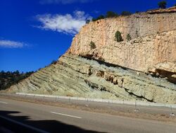
 Romeroville Sandstone beds resting on Pajarito Formation, I-25 road cut, Romeroville, New Mexico, USA | |
| Type | Formation |
| Unit of | Dakota Group |
| Underlies | Graneros Shale |
| Overlies | Pajarito Formation |
| Thickness | up to 9 m (30 ft) |
| Lithology | |
| Primary | Sandstone |
| Other | Siltstone |
| Location | |
| Coordinates | [ ⚑ ] 35°31′33″N 105°14′17″W / 35.5258°N 105.2380°W |
| Region | New Mexico |
| Country | |
| Type section | |
| Named for | Settlement of Romeroville, New Mexico |
| Named by | Kues and Lucas |
| Year defined | 1987 |
The Romeroville Sandstone is a geologic formation in northeastern New Mexico.[1][2] It likely was deposited in the Cenomanian Age of the Cretaceous Period.[3]
Description
The formation consists of yellow-gray quartz sandstone with minor siltstone. The sandstone is planar crossbedded and bioturbated[1] and locally pebbly.[2] It overlies the Pajarito Formation and is in turn overlain by the Graneros Shale. Maximum thickness is 9 meters (30 ft).[1]
The formation is interpreted as the onset of a marine transgression of the Greenhorn cycle.[1]
History of investigation
The formation was first named by Kues and Lucas in 1987 for previously undivided Dakota Group beds at the Romeroville Gap. Kues and Lucas also identified it at Clayton Lake and in the valley of the Dry Cimarron.[1]
References
Bibliography
- Kues, B.S.; Lucas, S.G. (1987). "Cretaceous stratigraphy and paleontology in the Dry Cimarron Valley, New Mexico, Colorado, and Oklahoma". New Mexico Geological Society Field Conference Guidebook 38: 167–198. https://nmgs.nmt.edu/publications/guidebooks/downloads/38/38_p0167_p0198.pdf. Retrieved 2 September 2020.
- Lucas, Spencer G.; Hunt, Adrian P. (2000). "The lower Cretaceous ammonite Mortoniceras equidistans (Cragin) from the Mesa Rica Sandstone, Quay County, New Mexioco". New Mexico Museum of Natural History and Science Bulletin 16: 97–100. https://books.google.com/books?id=El8fCgAAQBAJ&q=%22mesa+rica%22&pg=PA97. Retrieved 3 September 2020.
- Ziegler, Kate E.; Ramos, Frank C.; Zimmerer, Matthew J. (2019). "Geology of Northeastern New Mexico, union and Colfax Counties, New Mexico: A Geologic Summary". New Mexico Geological Society Field Conference Series 70 (4): 47–54. https://nmgs.nmt.edu/publications/guidebooks/downloads/70/70_p0047_p0054.pdf. Retrieved 1 September 2020.
 |


