Earth:Pierre's Pot
From HandWiki
Short description: Cave in Somerset, England
| Pierre's Pot | |
|---|---|
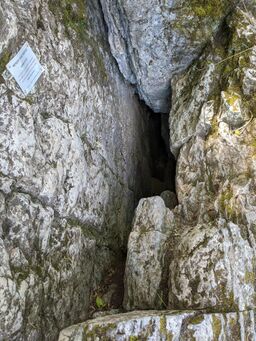
 Pierre's Pot entrance | |
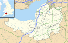
| Location | Burrington Combe, Somerset, UK |
| OS grid | ST 47635837 |
| Coordinates | [ ⚑ ] 51°19′19″N 2°45′11″W / 51.32201°N 2.75292°W |
| Depth | 47 metres (154 ft) |
| Length | 985 metres (3,232 ft) |
| Geology | Carboniferous limestone[1] |
| Entrances | 1 |
| Hazards | |
| Access | Free |
| Registry | Mendip Cave Registry[2] |
Pierre's Pot is a karst cave in Burrington Combe on the Mendip Hills in Somerset, England .
The cave was discovered in 1983 and has two main levels, the lower level being reached through an extremely tight rift. There is an active streamway and sump which, following a 15 m (49 ft) dive, leads to another streamway and a number of passages.[3]
The derivation of the cave's name is from one of the nicknames of Mike "Fish" Jeanmaire of the Axbridge Caving Group in the early 1960s.[4]
See also
References
- ↑ Farrant, Andrew. "Burrington Combe". Foundations of the Mendips website. Foundations of the Mendips. http://www.bgs.ac.uk/mendips/localities/Burrington.html.
- ↑ "Pierre's Pot". Mendip Cave Registry & Archive. http://www.mcra.org.uk/registry/sitedetails.php?id=33. Retrieved 2011-11-03.
- ↑ Irwin, David John; Knibbs, Anthony J. (1999). Mendip Underground: A Cavers Guide. Bat Products. ISBN 0-9536103-0-6.
- ↑ Witcombe, Richard (2009). Who was Aveline anyway?: Mendip's Cave Names Explained (2nd ed.). Priddy: Wessex Cave Club. pp. 130–131. ISBN 978-0-9500433-6-4.
 |

