Earth:Pouakai Range
From HandWiki
| Pouakai Range | |
|---|---|
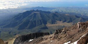
 The Pouakai Range as seen from Mount Taranaki, with the Kaitake Range in the background. | |
| Highest point | |
| Peak | Pouakai |
| Elevation | 1,395 m (4,577 ft) |
| Coordinates | [ ⚑ ] : 39°14′17″S 174°00′51″E / 39.23806°S 174.01417°E |
| Geography | |
| Location | North Island, New Zealand |
The Pouakai Range is a mountain range on the North Island of New Zealand, located northwest of Mount Taranaki. It is volcanic in origin, consisting of the remains of an eroded Pleistocene stratovolcano. The range is surrounded by a ring plain of lahar deposits that have been dated roughly 250,000 years old.[1]
Other Volcanoes In The Area
Sugar Loaf Islands - Dated -1.7 Million Years
Kaitake Volcano - Dated -500 Thousand Years
Taranaki Volcano - Dated -127 Thousand Years
References

