Earth:Qiangtang terrane
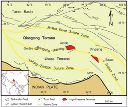
The Qiantang terrane is one of three main west-east-trending terranes of the Tibetan Plateau.
During the Triassic, a southward-directed subduction along its northern margin resulted in the Jin-Shajing suture, the limit between it and the Songpan-Ganzi terrane. During the Late Jurassic and Early Cretaceous, the Lhasa terrane merged with its southern margin along the Bangong suture.[1] This suture, the closure of part of the Tethys Ocean, transformed the Qiantang terrane into a large-scale anticline.[2] The merging of the Lhasa and Qiangtang terranes resulted in the uplift of a palaeoplateau known as the Qiangtang Plateau,[3] which rapidly thinned later in the Cretaceous.[4]
The Qiantang terrane is now located at c. 5,000 m (16,000 ft) above sea level, but the timing of this uplift remains debated, with estimates ranging from the Pliocene-Pleistocene (3–5 Mya) to the Eocene (35 Mya) when the plateau was first denudated.[5]
See also
Qiangtang terrane related (from south to north)
- Transhimalaya, includes following:
- Lhasa terrane
- Karakoram fault system
- High pressure metamorphic terranes along the Bangong-Nujiang Suture Zone
- Qiangtang terrane
References
Notes
- ↑ Wang et al. 2008, Geologic setting, p. 475
- ↑ Xu et al. 2013, Geologic setting, pp. 32–33
- ↑ Zhang, Chenyu; Wu, Lei; Chen, Wuke; Zhang, Yongshu; Xiao, Ancheng; Zhang, Junyong; Chen, Siyuan; Chen, Hanlin (1 November 2020). "Early Cretaceous foreland-like Northeastern Qaidam Basin, Tibetan Plateau and its tectonic implications: Insights from sedimentary investigations, detrital zircon U–Pb analyses and seismic profiling". Palaeogeography, Palaeoclimatology, Palaeoecology 557: 109912. doi:10.1016/j.palaeo.2020.109912. Bibcode: 2020PPP...557j9912Z. https://www.sciencedirect.com/science/article/abs/pii/S0031018220303576. Retrieved 7 December 2022.
- ↑ Sun, Miao; Tang, Ju-Xing; Chen, Wei; Ma, Xu-Dong; Qu, Xiao-Ming; Song, Yang; Li, Xin-Yuan; Ding, Ji-Shun (March 2020). "Process of lithospheric delamination beneath the Lhasa–Qiangtang collision orogen: Constraints from the geochronology and geochemistry of Late Cretaceous volcanic rocks in the Lhasa terrane, central Tibet". Lithos 356-357: 105219. doi:10.1016/j.lithos.2019.105219. https://www.sciencedirect.com/science/article/abs/pii/S0024493719303780. Retrieved 7 December 2022.
- ↑ Xu et al. 2013, Introduction, pp. 31–32
Sources
- Le Fort, P.; Cronin, V. S. (1 September 1988). "Granites in the Tectonic Evolution of the Himalaya, Karakoram and Southern Tibet". Philosophical Transactions of the Royal Society of London. Series A, Mathematical and Physical Sciences 326 (1589): 281–299. doi:10.1098/rsta.1988.0088. Bibcode: 1988RSPTA.326..281F.
- Wang, Q.; Wyman, D. A.; Xu, J.; Wan, Y.; Li, C.; Zi, F.; Jiang, Z.; Qiu, H. et al. (2008). "Triassic Nb-enriched basalts, magnesian andesites, and adakites of the Qiangtang terrane (Central Tibet): evidence for metasomatism by slab-derived melts in the mantle wedge". Contributions to Mineralogy and Petrology 155 (4): 473–490. doi:10.1007/s00410-007-0253-1. Bibcode: 2008CoMP..155..473W. https://www.researchgate.net/publication/225755754. Retrieved 1 January 2020.
- Xu, Q.; Ding, L.; Zhang, L.; Cai, F.; Lai, Q.; Yang, D.; Liu-Zeng, J. (2013). "Paleogene high elevations in the Qiangtang Terrane, central Tibetan Plateau". Earth and Planetary Science Letters 362: 31–42. doi:10.1016/j.epsl.2012.11.058. Bibcode: 2013E&PSL.362...31X. https://www.academia.edu/download/35843666/13_Xu2013EPSL_paleo-altimetry.pdf. Retrieved 1 January 2020.
 |


