Earth:Speedwell Cavern
| Speedwell Cavern | |
|---|---|
 | |
| Location | Castleton, Derbyshire, England |
| Coordinates | [ ⚑ ] : 53°20′29″N 1°47′32″W / 53.3414°N 1.7921°W |
| Geology | Limestone |
| Website | Official website |
| <graph>
{ // // ATTENTION: This code is maintained at https://www.mediawiki.org/wiki/Template:Graph:Street_map_with_marks // Please do not modify it anywhere else, as it may get copied and override your changes. // Suggestions can be made at https://www.mediawiki.org/wiki/Template_talk:Graph:Street_map_with_marks // // Template translation is in https://commons.wikimedia.org/wiki/Data:Original/Template:Graphs.tab // "version": 2, "width":255, "height": 300, "padding": 0, "signals":[ // These signals allow us to quickly move the map within the image, e.g. to leave space for the legend {"name":"legendWidth", "init": {"expr": "0"} }, {"name":"legendHeight", "init": {"expr": "height"} },
{"name":"imgWidth", "init": {"expr": "width-legendWidth"} },
{"name":"imgHeight", "init": {"expr": "height"} },
{"name":"imgXC", "init": {"expr": "imgWidth/2"} },
{"name":"imgYC", "init": {"expr": "imgHeight/2"} },
{"name":"imgTileSize", "init": {"expr": "256"} },
{"name":"imgLat", "init": {"expr": "53.3414"} },
{"name":"imgLon", "init": {"expr": "-1.7921"} },
{"name":"imgZoom", "init": {"expr": "11"} },
{"name":"picWidth", "init": {"expr": "180"} },
{"name":"picHeight", "init": {"expr": "picWidth/2"} },
{"name":"picXC", "init": {"expr": "imgWidth-(picWidth/2)"} },
{"name":"picYC", "init": {"expr": "imgHeight-(picHeight/2)"} },
{"name":"showMiniMap", "init": {"expr": "0"} }
],
"data": [
{
"name": "data",
// Otherwise use the first unnamed argument for source values "values": [ { "lat": 53.3414,
"lon": -1.7921,
"img": "wikirawupload:https://handwiki.org/wiki/images/thumb/1/10/Mapscaleline.svg/120px-Mapscaleline.svg.png",
"width": 50,
"height": 8,
"offsetX": 90.5,
"offsetY": 140,
"textAlign": "right",
"textDx": 22,
"textDy": -2,
"textColor": "grey",
"textFont": "Tahoma",
"textFontSize": 9,
"text": "3km" }
, { "lat": 0, "lon": 0, "img": "wikirawupload:https://handwiki.org/wiki/images/thumb/0/0c/Red_pog.svg/10px-Red_pog.svg.png", "height": 10, "width": 10, "text": "", "textAngle": 0, "textAlign": "right", "textBaseline": "middle", "textDx": -7, "textDy": 1, "textFontSize": 12, "textColor": "#AA1205"
}
, { "lat": 53.3333, "lon": -1.79329, "img": "wikirawupload:https://handwiki.org/wiki/images/thumb/0/0c/Red_pog.svg/8px-Red_pog.svg.png", "height": 8, "width": 8, "text": "Titan", "textAngle": 0, "textAlign": "right", "textBaseline": "middle", "textDx": -6, "textDy": 1, "textFontSize": 10, "textColor": "#888866"
} , { "lat": 53.3456, "lon": -1.8035, "img": "wikirawupload:https://handwiki.org/wiki/images/thumb/0/0c/Red_pog.svg/8px-Red_pog.svg.png", "height": 8, "width": 8, "text": "Blue John Cavern", "textAngle": 0, "textAlign": "center", "textBaseline": "bottom", "textDx": 0, "textDy": -6, "textFontSize": 10, "textColor": "#888866"
} , { "lat": 53.3451, "lon": -1.7972, "img": "wikirawupload:https://handwiki.org/wiki/images/thumb/0/0c/Red_pog.svg/8px-Red_pog.svg.png", "height": 8, "width": 8, "text": "Treak Cliff Cavern", "textAngle": 0, "textAlign": "left", "textBaseline": "middle", "textDx": 6, "textDy": -2, "textFontSize": 10, "textColor": "#888866"
} , { "lat": 53.3409, "lon": -1.7791, "img": "wikirawupload:https://handwiki.org/wiki/images/thumb/0/0c/Red_pog.svg/8px-Red_pog.svg.png", "height": 8, "width": 8, "text": "Peak Cavern", "textAngle": 0, "textAlign": "left", "textBaseline": "middle", "textDx": -1, "textDy": 10, "textFontSize": 10, "textColor": "#888866"
} , { "lat": 53.3414, "lon": -1.7921, "img": "wikirawupload:https://handwiki.org/wiki/images/thumb/0/0c/Red_pog.svg/11px-Red_pog.svg.png", "height": 11, "width": 11, "text": "Speedwell Cavern", "textAngle": 0, "textAlign": "right", "textBaseline": "middle", "textDx": -7, "textDy": 1, "textFontSize": 13, "textColor": "#666644"
}
     ],
     "transform": [
       {
         "type": "geo",
         "projection": "mercator",
         "scale": {"expr": "imgTileSize/PI/2*pow(2,imgZoom)"},
         "translate": [{"expr": "imgXC"}, {"expr": "imgYC"}],
         "center": [{"expr": "imgLon"}, {"expr": "imgLat"}],
         "lon": "lon", "lat": "lat"
       },
       { "type": "formula", "field":"layout_x", "expr": "datum.layout_x + (datum.offsetX || 0)" },
       { "type": "formula", "field":"layout_y", "expr": "datum.layout_y + (datum.offsetY || 0)" },
       { "type": "formula", "field":"color", "expr": "datum.color || '#c33'" },
       { "type": "formula", "field":"textColor", "expr": "datum.textColor || datum.color" },
       { "type": "formula", "field":"strokeColor", "expr": "datum.strokeColor || '#ffe7e6'" }
     ]
   },
   {
     // Hack: single value data source for drawing/hiding images and other non-series elements
     "name": "dummyData",
     "values": [{}]
   }
 ],
// Legend only works if showLegend and colorScaleField are set "marks": [
{
"type": "image",
"from": {
"data": "dummyData",
"transform": [
{ "type": "formula", "field":"url", "expr": "'mapsnapshot:///?width='+imgWidth+'&height='+imgHeight+'&zoom='+imgZoom+'&lat='+imgLat+'&lon='+imgLon" }
]
},
"properties": {
"enter": {
"url": {"field": "url"},
"xc": {"signal": "imgXC"}, "yc": {"signal": "imgYC"},
"width": {"signal": "imgWidth"}, "height": {"signal": "imgHeight"}
}
}
},
{
// Places an image of a given name and size at the [lan,lon] location
"type": "image",
"from": {
"data": "data",
"transform": [
{ "type": "filter", "test": "datum.img" },
{ "type": "formula", "field":"iconWidth", "expr": "datum.width || 0" },
{ "type": "formula", "field":"iconHeight", "expr": "datum.height || 0" },
{ "type": "formula", "field":"img",
"expr": "if(!test(/^[a-z]+:\\/\\//, datum.img), 'wikifile:///'+datum.img, datum.img)" },
// Ensure that either width or height parameter is passed to wikifile:// request
{ "type": "formula", "field":"img",
"expr": "if((datum.iconWidth || datum.iconHeight) && !test(/[?&](width|height)=\\d/, datum.img),if(datum.iconWidth,datum.img+'?width='+datum.iconWidth,datum.img+'?height='+datum.iconHeight), datum.img)" }
]},
"properties": {
"enter": {
"url": {"field": "img"},
"xc": {"field": "layout_x"}, "yc": {"field": "layout_y"},
"width": {"field": "iconWidth"}, "height": {"field": "iconHeight"}
}
}
},
{
// Draw marks of a given color, shape, and size at the [lan,lon] location
"type": "symbol",
"from": {
"data": "data",
"transform": [{ "type": "filter", "test": "!datum.img" }]
},
"properties": {
"enter": {
"x": {"field": "layout_x"},
"y": {"field": "layout_y"},
// If colorScaleField is set, use color scaling, otherwise use the preset color value
"fill": { "field": "color" },
"size": {"field": "size"},
"shape": {"field": "shape"},
"stroke": {"field": "strokeColor"}
}
}
},
{
// Draw text with the given color and size at the [lan,lon] location
// See https://github.com/vega/vega/wiki/Marks#text for all parameter description (prepend "text" and capitalize them)
"type": "text",
"from": {
"data": "data",
"transform": [
{ "type": "filter", "test": "datum.text" },
// Figure out if this is an LTR or RTL page. For LTR, show label to the right of the icon, left-aligned. For RTL, reverse.
{ "type": "formula", "field":"isLTR", "expr": "'' == '\\u200E'" },
// If these values are not defined ("undefined" is not allowed, so test for truthiness and not 0)
{ "type": "formula", "field":"textDx", "expr": "if(!datum.textDx && datum.textDx != 0, if(datum.isLTR,8,-8), datum.textDx)" },
{ "type": "formula", "field":"textAlign", "expr": "if(!datum.textAlign, if(datum.isLTR,'left','right'), datum.textAlign)" },
{ "type": "formula", "field":"textBaseline", "expr": "datum.textBaseline || 'middle'" }
]},
"properties": {
"enter": {
"text": {"field": "text"},
"x": {"field": "layout_x" },
"y": {"field": "layout_y"},
"dx": {"field": "textDx" },
"dy": {"field": "textDy"},
"fill": {"field": "textColor"},
"align": {"field": "textAlign"},
"baseline": {"field": "textBaseline"},
"radius": {"field": "textRadius"},
"theta": {"field": "textTheta"},
"angle": {"field": "textAngle"},
"font": {"field": "textFont"},
"fontSize": {"field": "textFontSize"},
"fontWeight": {"field": "textFontWeight"},
"fontStyle": {"field": "textFontStyle"}
}
}
},
{
// Draw a low-zoom locator map frame
"type": "rect",
"from": {
"data": "dummyData",
"transform": [
{ "type": "filter", "test": "showMiniMap" }
]
},
"properties": {
"enter": {
"xc": {"signal": "picXC"}, "yc": {"signal": "picYC"},
"width": {"signal": "picWidth", "offset":2}, "height": {"signal": "picHeight"},
"stroke": {"value":"#fff"},"strokeWidth": {"value":6}
}
}
},
{
// Draw a low-zoom locator map by using a premade world map image
"type": "image",
"from": {
"data": "dummyData",
"transform": [
{ "type": "filter", "test": "showMiniMap" },
{ "type": "formula", "field":"url", "expr": "1" }
]
},
"properties": {
"enter": {
"url": {"value": "wikirawupload:https://handwiki.org/wiki/images/thumb/a/ac/Earthmap1000x500.jpg/180px-Earthmap1000x500.jpg"},
"xc": {"signal": "picXC"}, "yc": {"signal": "picYC"},
"width": {"signal": "picWidth"}, "height": {"signal": "picHeight"}
}
}
},
{
// Draw a zoom-out mark at the [lan,lon] location
"type": "symbol",
"from": {
"data": "dummyData",
"transform": [
{ "type": "filter", "test": "showMiniMap" },
{ "type": "formula", "field":"lat", "expr": "imgLat" },
{ "type": "formula", "field":"lon", "expr": "imgLon" },
{
"type": "geo",
"projection": "equirectangular",
"scale": {"expr": "180/2/PI"},
"translate": [{"expr": "picXC"}, {"expr": "picYC"}],
"center": [{"expr": "0"}, {"expr": "0"}],
"lon": "lon", "lat": "lat"
}
]
},
"properties": {
"enter": {
"x": {"field": "layout_x"}, "y": {"field": "layout_y"},
"fill": {"value": "#c33"},
"stroke": {"value": "#ffe7e6"},
"size": {"value": 40}
}
}
}
]
} </graph> <maplink zoom="12" latitude="53.3414" longitude="-1.7921" text="[Interactive fullscreen map]">
[
"features": [
  "properties": {
   "title": "Titan (cave)",
   "description": " 53.3333,-1.79329",
   "marker-symbol": "-number", "marker-size": "medium", "marker-color": "#AA1205" },
  "geometry": {"type": "Point", "coordinates": [-1.79329,53.3333] }
}
, { "type": "Feature", "properties": {
"title": "Blue John Cavern",
"description": " 53.3456,-1.8035",
"marker-symbol": "-number", "marker-size": "medium", "marker-color": "#AA1205" },
"geometry": {"type": "Point", "coordinates": [-1.8035,53.3456] }
}
, { "type": "Feature", "properties": {
"title": "Treak Cliff Cavern",
"description": " 53.3451,-1.7972",
"marker-symbol": "-number", "marker-size": "medium", "marker-color": "#AA1205" },
"geometry": {"type": "Point", "coordinates": [-1.7972,53.3451] }
}
, { "type": "Feature", "properties": {
"title": "Peak Cavern",
"description": " 53.3409,-1.7791",
"marker-symbol": "-number", "marker-size": "medium", "marker-color": "#AA1205" },
"geometry": {"type": "Point", "coordinates": [-1.7791,53.3409] }
}
, { "type": "Feature", "properties": {
"title": "Speedwell Cavern",
"description": "
|
| Location of Speedwell Cavern, Derbyshire, and the other nearby caves. |
Speedwell Cavern is one of the four show caves in Castleton, Derbyshire, England.[1]
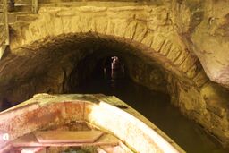
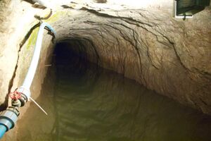
The cave system consists of a horizontal lead miners' adit (a level passageway driven horizontally into the hillside) 200 metres (660 ft) below ground leading to the cavern itself, a limestone cave. The narrow adit is permanently flooded, so after descending a long staircase, access to the cave is made by boat. At the end of the adit, the cavern opens up with fluorspar veins, stalactites and stalagmites, and the so-called "Bottomless Pit". This chamber has an underground lake with a 20 metres (66 ft) high waterfall and an extremely deep vertical shaft, now choked to within 20 metres (66 ft) of the surface by rock spoil dumped by miners, after driving the continuation of the canal to the natural streamway beyond, which provided the bulk of the water for the canal. The original depth of the shaft has been estimated, from the amount of spoil placed in the shaft over the years, at around 150 metres (490 ft).[2]
The mine was developed in the 1770s but the limited lead ore deposits meant that it was not profitable and it was closed down by 1790.[3]
At the foot of Winnats Pass, it is a tourist attraction with an underground boat trip to the cavern. Originally the guide propelled the boat by pushing against the walls with his hands, later the boat was legged through, and now it is powered by an electric motor.
A connection was discovered in 2006 between the Speedwell Cavern system and Titan, the largest natural shaft in the UK, which is 141.5 metres (464 ft) high.[4]
References
- ↑ "The Peak District, Derbyshire". British Geological Survey. https://www.bgs.ac.uk/discoveringGeology/geologyOfBritain/limestoneLandscapes/regionalStudies/peakDistrict.html.
- ↑ "Speedwell Cavern". https://www.showcaves.com/english/gb/showcaves/Speedwell.html.
- ↑ Ford, Trevor (1961). The Story of the Speedwell Cavern. R J & D Harrison.
- ↑ "Titan – king of the caverns". 6 November 2006. http://www.bbc.co.uk/insideout/yorkslincs/series10/week9_titan_cave.shtml.
 |

