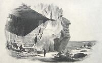
Earth:Tura, Egypt
Tura (Egyptian Arabic: طرة Script error: The function "transl" does not exist. IPA: [ˈtˤoɾˤɑ], Coptic: ⲧⲣⲱⲁ, Ancient Greek:[1]) was the primary quarry for limestone in ancient Egypt.[2] The site, which was known by the ancient Egyptians as Troyu or Royu, is located about halfway between modern-day Cairo and Helwan.[3] Its ancient Egyptian name was misinterpreted by the ancient Greek geographer Strabo, who thought it meant it was inhabited by Trojans, thus the Hellenistic city was named Troia.[4] The site is located by the modern town of Tora in the Cairo Governorate.[5]
Ancient mining town
| <hiero>r:Z1-Aw-w-N25</hiero> |
| rꜣ-ꜣw in hieroglyphs |
|---|
The limestone from Tura was the finest and whitest of all the Egyptian quarries, so it was used for facing stones for the richest tombs,[6] as well as for the floors and ceilings of mastabas, which were otherwise made of mudbrick.[7] It was used during the Old Kingdom and was the source of the limestone used for the "Rhomboidal Pyramid" or Bent Pyramid of Sneferu,[8] the Great Pyramid of Khufu,[9] the sarcophagi of many Old Kingdom nobles,[10] the pyramids of the Middle Kingdom,[11] and certain temples of the New Kingdom built by at least Ahmose I, who may have used Tura limestone to begin the temple of Ptah at Memphis and the Southern Harem of Amun at Thebes.[12]
The Tura limestone was deep underground and instead of open-pit mining, the miners tunneled deep underground to cut large stones out, leaving some limestone behind to support the caverns left behind.[4] These tunnels were surveyed by British Forces in 1941, and in quarry 35, workmen found many loose quires from books by Origen and Didymus the Blind, two Alexandrian Church Fathers. The workers who found them stole them, and although some were seized by the authorities, most are still missing, and turn up on the antiquities market from time to time. It is believed that some of the original books could have been up to 480 pages.[13]
The caves were adapted by British forces during World War II initially used to store a variety of equipment, including munitions.[14] In 1942 it was decided they would serve better as a bomb-proof location for the repair of aircraft engines by the Royal Air Force , and it was the engine repair section under 111 Maintenance Unit that was inspected on 22 August 1942 by Winston Churchill who recorded that "Everything looked very smart and efficient on the spot, and an immense amount of work was being done day and night by masses of skilled men. But I had my tables of facts and figures and remained dissatisfied. The scale was far too small."[15] The use of the caves for RAF aircraft engine repairs continued until 1945.
See also
- List of ancient Egyptian sites, including sites of temples
- List of types of limestone
References
- ↑ Peust, Carsten. "Die Toponyme vorarabischen Ursprungs im modernen Ägypten". p. 99. http://www.peust.de/ortsnamen_original.pdf.
- ↑ Grimal, Nicholas. A History of Ancient Egypt. p. 27. Librairie Arthéme Fayard, 1988
- ↑ Grimal, Nicholas. A History of Ancient Egypt. p. 111. Librairie Arthéme Fayard, 1988
- ↑ 4.0 4.1 Quarries of Masara and Tura Accessed July 28, 2006
- ↑ Talbert, Richard. Barrington Atlas of the Greek and Roman World. p. 74. (ISBN:0-691-03169-X)
- ↑ Tura Accessed 2009-06-16
- ↑ Helwan Accessed July 28
- ↑ Grimal, Nicholas. A History of Ancient Egypt. p. 109. Librairie Arthéme Fayard, 1988
- ↑ Great Pyramid Accessed July 28, 2006
- ↑ Grimal, Nicholas. A History of Ancient Egypt. p. 129. Librairie Arthéme Fayard, 1988
- ↑ Grimal, Nicholas. A History of Ancient Egypt. p. 177. Librairie Arthéme Fayard, 1988
- ↑ Grimal, Nicholas. A History of Ancient Egypt. p. 200. Librairie Arthéme Fayard, 1988
- ↑ The Tury Discovery of Manuscripts Accessed July 28, 2006
- ↑ Playfair, Vol. I, page 65.
- ↑ Churchill, Winston. The Second World War, Vol IV, The Hinge of Fate, Chapter XXIX, p468
Bibliography
- Playfair, Major-General I.S.O.; Molony, Brigadier C.J.C.; with Flynn, Captain F.C. (R.N.); Gleave, Group Captain T.P. (2009). Butler, Sir James. ed. The Mediterranean and Middle East, Volume I: The Early Successes Against Italy, to May 1941. History of the Second World War, United Kingdom Military Series. Uckfield, UK: Naval & Military Press. ISBN 978-1-84574-065-8.
[ ⚑ ] 29°51′10″N 31°20′45″E / 29.85278°N 31.34583°E
 |


