Earth:Zavaritski Caldera
From HandWiki
Short description: Volcanic crater in the Kuril Islands, Russia
| Zavaritski Caldera | |
|---|---|
 | |
| Highest point | |
| Elevation | 624 m (2,047 ft) |
| Coordinates | [ ⚑ ] 46°55′30″N 151°57′00″E / 46.925°N 151.95°E |
| Geography | |
| Location | Simushir, Kuril Islands, Russia |
| Geology | |
| Mountain type | Caldera |
| Last eruption | November to December 1957 |
| Lua error in Module:Mapframe at line 384: attempt to perform arithmetic on local 'lat_d' (a nil value). | |
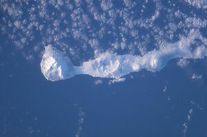
Zavaritski Caldera (Russian: Вулкан Заварицкого, Vulkan Zavaritskogo) is a caldera located in the central part of Simushir Island, Kuril Islands, Russia . Lake Biryuzovoe partially fills the youngest of three nested calderas on the volcano.
The volcano is named after Alexander Nikolayevich Zavaritski, scientist of the Academy of Sciences of the Soviet Union.
See also
- List of volcanoes in Russia
References
- "Zavaritzki Caldera". Smithsonian Institution. https://volcano.si.edu/volcano.cfm?vn=290180.
- Aerial image retrieve from NASA Technical Reports Server on 19 April 2007.
 |


