Engineering:Roadside park
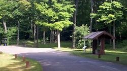
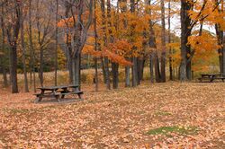
A roadside park is a designated park on the wide side of a road for the traveling tourist usually maintained by a governmental entity, either local, state, or national. It is for recreational use such as a picnic spot or a trail head. A roadside park will generally be found in a rural setting, whereas a rest area will be found on an interstate highway in a suburban setting or between major destinations like cities. A rest area is specifically designed for the rest and relaxation of the motoring public. The roadside park with the use of picnic tables is the predecessor of the modern rest area / travel plaza.[1]
Different states would have formal and informal designations for these spots, including "roadside table," "wayside table," "wayside park," or "wayside picnic area."
Many roadside parks have restroom facilities or at least pit toilets, where some small roadside parks have no restroom facilities at all. Some have water and many are designated on state maps with a small picnic table.
Some continents have roadside parks, however they are not a worldwide phenomenon. They are popular in the United States , Canada , Australia and Europe, however basically not known in Mexico, Central America, South America, Africa, nor Asian countries.
History
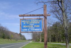
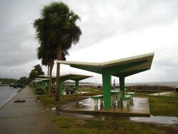
Herbert F. Larson started the idea of the roadside park.[2] History records that the idea goes back to 1918 in the early days of auto touring.[2] Larson was then a history-minded highway engineer just out of the University of Michigan School of Engineering.[2] He came back to Iron County where he grew up to manage the highway department.[2]
Most of the big pines in Iron County were being cut down by the lumber companies at this time. Larson seeing this hoped someday to keep scenic wide strips of old growth trees along Iron County's principal roads. He envisioned the possibility of a living forest memorial of virgin hardwoods so that posterity could see and enjoy what nature had richly bestowed upon us.[2] In his words he
| “ | tried to keep alert and ahead of the woodsman's axe.[3] | ” |
The inspiration of the roadside park idea came from a disappointed Sunday outing of a nearby Wisconsin lake country picnic. In 1919 northern Wisconsin lake resorts were growing rapidly. On a particular Sunday of that year, Larson tried to have a cookout with a group of people in Wisconsin. Everywhere they went the property caretaker asked them to not have their picnic on the property and escourted them off the grounds.
Larson wrote,
| “ | In upper Michigan we could go where we chose with no one to bother us.[2] | ” |
He did not want the nearby Upper Peninsula of Michigan to suffer a similar loss of the much-loved pastime of picnicking. This is where he was inspired with the idea of a wide right of way road spot as a roadside park.[2] One day Larson learned that a particular prominently located parcel of land of uncut virgin woods east of Iron River, Michigan, on U.S. 2 might be up for sale. He went to the landowners with the support of the Iron County board chairman. They then negotiated with the owners and bought it as a forest memorial public woods.[2] This is where he placed his first picnic table for a designated rest spot for the motoring public.[2][4][5] There is a possibility this was even the first designated automobile rest area anywhere in the world.[2][6][7] It is located at coordinates N 46.1067 W -88.54.78[8] in a stand of old-growth hardwood trees. Presently, it has many picnic tables and grills. There are pit toilets provided there today, whereas when it was first introduced it consisted only of a single picnic table.[2]
Larson's roadside park rest stop idea quickly spread all over the United States in most of the states already by the 1920s.[2] His roadside park idea soon attracted large gatherings and became a trend-setting phenomenon.[2] Its success inspired Larson's later projects of Pentoga Park[1] and Bewabic Park.[3]
Michigan historical marker
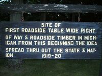
There is a historical marker at the Iron River site that reads:
| “ | In 1918 the Iron County Board of Supervisors approved the recommendation of the road commission, through its engineer-manager, Herbert F. Larson, to purchase this 320-acre (1.3 km2) tract of roadside virgin timber and to dedicate it as a forest preserve. The following year Iron County established Michigan's first roadside park and picnic tables. This was quite likely America's first such facility. Since then similar parks have been provided by most states for the comfort and enjoyment of the traveling motorist.[9][10] | ” |
References
- ↑ 1.0 1.1 "Pentoga Park". http://hunts-upguide.com/iron_river_pentoga_park.html.
- ↑ 2.00 2.01 2.02 2.03 2.04 2.05 2.06 2.07 2.08 2.09 2.10 2.11 2.12 "Iron River - First Roadside Table". http://hunts-upguide.com/iron_river_first_roadside_table.html.
- ↑ 3.0 3.1 "Bewabic Park". http://hunts-upguide.com/crystal_falls_bewabic_state_park.html.
- ↑ "First Roadside Park Historical Marker - Iron County". http://michigan.hometownlocator.com/maps/BIGmap,n,First%20Roadside%20Park%20Historical%20Marker,FID,2129533.cfm.
- ↑ "Michigan Department of Transportation". http://www.michigan.gov/mdot/0,1607,7-151-9620_11154-129682--,00.html.
- ↑ "Iron County time line". http://www.iron.org/history/ictimeline.html.
- ↑ American Highways By American Association of State Highway Officials, page 16, Published 1973, Original at University of Michigan
- ↑ "USGS Feature ID: 2129533 First Roadside Park Historical Marker". http://geonames.usgs.gov/pls/gnispublic/f?p=gnispq:3:10260305305329175906::NO::P3_FID:2129533.
- ↑ "Michigan Historical Markers". http://www.michmarkers.com/startup.asp?startpage=S0213.htm.
- ↑ A Guide to Michigan's Historical Markers By Laura Rose Ashlee, page 193, Published 2005 by University of Michigan Press, ISBN 0-472-03066-3
