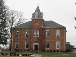
Organization:Union Bible College and Academy
 Union Bible College and Academy | |
| Type | Private high school, college, and seminary |
|---|---|
| Established | 1911 |
Religious affiliation | Central Yearly Meeting of Friends (Quakerism) |
| President | C. Adam Buckler |
| Location | Westfield , , United States |
| Campus | Suburban college town |
| Website | ubca |
Union Bible College and Academy is a private Quaker educational institution combining a high school, college, and seminary in Westfield, Indiana.[1] It was founded in 1911 by the Central Yearly Meeting of Friends and is a part of the wider conservative holiness movement.[1] It was listed on the National Register of Historic Places in 1995.[2]
History
In 1860, members of the Religious Society of Friends, concerned about the spiritual and academic upbringing of their children in light of the American Civil War, constructed a two-story brick building that came to be known as Union High School. It went into operation on January 7, 1861.
At the turn of the twentieth century, amid waning enrollment due to the advent of public schools in the area, a minister named William M. Smith was approached by the school committee to expand the operations of the campus. They wanted to incorporate training programs for aspiring ministers and missionaries. Smith accepted the offer and founded Union Bible Seminary in May 1911.
In 1980, both the seminary and academy assumed an interdenominational status. In June 1989, the seminary was renamed as Union Bible College.[3]
Accreditation
Union Bible College is accredited by the Association for Biblical Higher Education.[4]
Campus
Union High Academy Historic District | |
| Lua error in Module:Location_map at line 522: Unable to find the specified location map definition: "Module:Location map/data/Indiana" does not exist. | |
| Location | 434 S. Union St., Westfield, Indiana |
|---|---|
| Coordinates | [ ⚑ ] : 40°2′19″N 86°7′34″W / 40.03861°N 86.12611°W |
| Area | 4 acres (1.6 ha) |
| Built | 1861-1929 |
| Architectural style | Greek Revival, Tudor Revival, Bungalow/craftsman |
| NRHP reference # | 95000209[2] |
| Added to NRHP | March 3, 1995 |
Union High Academy Historic District is a historic Quaker academic institution including a high school, college and seminary,[5] as well as a national historic district located at Westfield, Hamilton County, Indiana. It encompasses five contributing buildings built between 1861 and 1929. They are the Greek Revival / Italianate style main classroom building (1861, 1883, 1946, 1953); Greek Revival style President's House (Estes House, 1861), a frame dormitory (1929), and two brick dormitories (c. 1861) that are now private homes.[6]
Newspaper
The student newspaper published by Union Bible College and Seminary is The Union Minister.
References
- ↑ 1.0 1.1 Abbott, Margery Post; Chijioke, Mary Ellen; Dandelion, Pink (2012) (in English). Historical Dictionary of the Friends (Quakers). Scarecrow Press. p. 79. ISBN 9780810868571.
- ↑ 2.0 2.1 "National Register Information System". National Register of Historic Places. National Park Service. July 9, 2010. https://npgallery.nps.gov/NRHP.
- ↑ "History of UBCA". https://ubca.org/about-us/history/.
- ↑ "Union Bible College" (in English). Association for Biblical Higher Education. https://www.abhe.org/wp-content/uploads/2019/01/FCT-Union-Bible-College-IN.pdf. Retrieved 9 June 2019.
- ↑ Bodenhamer, David J.; Barrows, Robert G. (1994) (in English). The Encyclopedia of Indianapolis. Indiana University Press. ISBN 9780253112491.
- ↑ "Indiana State Historic Architectural and Archaeological Research Database (SHAARD)" (Searchable database). Department of Natural Resources, Division of Historic Preservation and Archaeology. https://secure.in.gov/apps/dnr/shaard/welcome.html. Retrieved 2016-04-01. Note: This includes Robert D. Hartman and Suzanne Fischer (September 1994). "National Register of Historic Places Inventory Nomination Form: Union High Academy Historic District" (PDF). https://secure.in.gov/apps/dnr/shaard/r/21975/N/Union_High_Academy_HD_Hamilton_CO_Nom.pdf. Retrieved 2016-04-01., accompanying map, and Accompanying photographs.
External links

