Place:Atacama Region
Atacama Region Región de Atacama | |
|---|---|
 Nevado Tres Cruces National Park | |
 Flag  Seal  Coat of arms | |
 Map of Atacama Region | |
| Coordinates: [ ⚑ ] : 27°22′00″S 70°19′56″W / 27.3666667°S 70.33222°W | |
| Country | |
| Capital | Copiapó |
| Provinces | Chañaral, Copiapó, Huasco |
| Government | |
| • Intendant | Francisco Sánchez (RN) |
| Area | |
| • Total | 75,176.2 km2 (29,025.7 sq mi) |
| Area rank | 4 |
| Highest elevation | 6,891.3 m (22,609.3 ft) |
| Lowest elevation | 0 m (0 ft) |
| Population (2024 census)[2] | |
| • Total | 299,180 |
| • Rank | 13 |
| • Density | 4.0/km2 (10/sq mi) |
| GDP (PPP) | |
| • Total | $8.595 billion (2014) |
| • Per capita | $27,882 (2014) |
| ISO 3166 code | CL-AT |
| HDI (2022) | 0.864[4] very high |
| Website | Official website Script error: The function "in_lang" does not exist. |
The Atacama Region (Spanish: Región de Atacama, es) is one of Chile's 16 first order administrative divisions. It comprises three provinces: Chañaral, Copiapó and Huasco. It is bordered to the north by Antofagasta, to the south by Coquimbo, to the east by the provinces of Catamarca, La Rioja and San Juan of Argentina, and to the west by the Pacific Ocean. The regional capital Copiapó is located 806 km (501 mi) north of the country's capital of Santiago. The region occupies the southern portion of the Atacama Desert, the rest of the desert is mainly distributed among the other regions of Norte Grande. As a generalization south of Copiapó River the region is mostly semi-arid and north of it is a true desert. The inland area in the north also differs from the southern part by hosting active volcanoes part of the Central Volcanic Zone of Andes.
The region has a long tradition of mining that features a silver rush from 1832 to 1850 and a strong development of iron mining from 1952 to 1966. Besides silver and iron the region also hosts valuable reserves of gold, copper and lithium. Agriculture in the region is mainly restricted to the valleys of Copiapó and Huasco where irrigation is aided by the dams of Lautaro and Santa Juana respectively. Crops cultivated include table grapes, olives, alfalfa and pisco grapes.
Demography
The Atacama Region is the third least populated region of the country, after Aisén and Magallanes. Of its total population, over 50% are located in the cities of Copiapó and Vallenar.
The largest cities are (2017 census data) Copiapó (150,804 inhabitants), Vallenar (45,298), Caldera (15,547), Chañaral (11,073), El Salvador (6,032) Tierra Amarilla (9,857), and Diego de Almagro (7,223).[5]
History
Pre-Hispanic period and the beginning of the history of Chile

Before the arrival of the Europeans, the territory of the present-day Atacama Region was inhabited by Diaguita communities in the valleys and Colla groups in the high Andean zone. The Diaguitas practiced irrigation agriculture, and the Collas raised camelids, both integrated into Andean exchange networks. By the 15th century, the area was incorporated into the Tahuantinsuyu (the Inca Empire), which introduced new forms of organization and infrastructure, such as roads and way stations (tambos).[6]
In 1536, the Spanish conquistador Diego de Almagro traveled through the Copiapó Valley during his expedition toward the southern part of the Inca Empire, an event often considered the first documented European contact with the territory that would later become part of Chile.
Later, in 1540, Pedro de Valdivia entered the Copiapó Valley after crossing the desert from the north. In that place, he held a symbolic ceremony to take possession of the land on behalf of the King of Spain and as a representative of Francisco Pizarro. There are different versions about the exact location of the act: some sources place it in Chamonate or Toledo, while others locate it near the current Ojancos plant. The event was recorded by the chronicler Jerónimo de Vivar, who described it as follows:
En jueves XXVI días del mes de octubre del año de nuestra salud de mil y quinientos quarenta, ante un escribano del rey y de representación real, el general tomo posesión en nombre de su majestad. Hizo las diligencias que en tal caso se requerían, diciendo en voz alta que emprendía y emprendió y tomaba y tomó posesión en aquel valle de Copiapó en nombre de su majestad. Ese valle de indios como de toda la gobernación que de allí en adelante tenía.
"On Thursday, the 26th day of October in the year of our salvation 1540, before a royal notary and royal representation, the general took possession in the name of His Majesty. He made the necessary efforts as required by such cases, loudly declaring that he embarked and took possession of the Copiapó Valley in the name of His Majesty. This valley of the Indians, along with the entire government, from that point onward, he had."
In 1548, Captain Juan Bohón established a fort in the Copiapó Valley. However, the fort was destroyed the following year during a Diaguita rebellion, in which its Spanish occupants were killed. The rebels later joined the indigenous uprising of La Serena, which culminated in the destruction of that city in 1549.
After these events, Pedro de Valdivia sent Captain Francisco de Aguirre to subdue the area. The so-called "pacification of Atacama" took place through armed confrontations that resulted in the defeat of the local populations. Aguirre then settled in the Fort of Montalván, from where the foundation of the future city of Copiapó began. (Guillermo Cortés Lutz, 2015)
Colonial period
During the colonial era, it was known as the northernmost boundary of the Captaincy General of Chile, which was under the Viceroyalty of Peru. On December 8, 1744, the city of San Francisco de Copiapó de la Selva (now Copiapó) was founded by Francisco Cortés. In 1789, by order of Governor Ambrosio O'Higgins, the city of Vallenar was founded. Atacama began to emerge as a mining development hub.
Republican period
During the Republican period, Juan Godoy discovered the silver ore of Chañarcillo in 1832. This discovery sparked a silver rush in Chile, which turned the country into one of the world’s leading producers of this metal and helped shape the emergence of the national economy. At that time, the region was part of the northern sector of the Coquimbo Province. However, due to the growing wealth of the area, it separated from Coquimbo and began functioning independently starting in 1843.
To improve transportation of the mineral to external markets, the first railway line in the country was built by William Wheelwright, a North American merchant and shipowner, connecting Copiapó to Caldera (1851). Over time, the national government began imposing taxes on economic activities in some provinces, especially on the mining of Atacama. These taxes clearly favored the capital, Santiago, which led to a severe political crisis and sparked a revolution in several Chilean provinces. In Atacama, this conflict escalated into an armed confrontation, with irregular rebel forces from the province of Atacama clashing with the Chilean Army, which had been deployed to suppress the revolution. This became known as the Revolution of 1859. Although the revolutionary side (the Atacama revolutionary army) was defeated at the Battle of Cerro Grande in 1859, the conflict marked the end of the Conservative Republic in Chile.
20th-century
In 1916, copper exploitation began in Potrerillos, creating a booming city that is now deserted and survives mainly through the smelting and refining of minerals, now extracted from the El Salvador mine.
Unlike other regions of Chile, Atacama presents a strong sense of regional identity, almost unique in Chile, rooted in its historical, economic, and cultural background. As a result, following the process of regionalization in the late 1970s, the Atacama Province saw no changes, and its successor, the Atacama Region, maintained its original structure.
21st-century

An unusual severe weather system caused rainfall throughout the region, leading to the overflow of the Salado and Copiapó rivers, leaving people isolated due to road closures and power outages. President Michelle Bachelet declared the area a disaster zone, and on March 25 a state of constitutional emergency was declared throughout the Atacama Region, as a result of which the Armed Forces took control of the area.
Geography

Interrupting the Intermediate Depression, a characteristic feature of the region is the presence of the so-called transverse mountain ranges, which connect the Coastal Range and the Andes Mountains. This gives rise to valleys running from east to west, which in turn form river valleys. These river valleys cut through the Coastal Range, which at this latitude can reach elevations exceeding 1,000 meters above sea level.
The Andes Mountains are very high in this region, with an average elevation of around 5,000 meters above sea level, and they reach the highest altitude in the country at the inactive volcano Nevado Ojos del Salado, which rises to approximately 6,893 meters above sea level, on the border with Argentina.
Several volcanoes, hills, and mountains are found in this region, including Azufre, El Ermitaño, El Fraile, El Muerto, Falso Azufre, Incahuasi, Los Patos, San Francisco, Sierras Nevadas, Tres Cruces, and Tres Cruces Central.
Hydrography
The region contains two types of hydrographic basins:
- Endorheic basins, located between the international border and the Pacific watershed. The most well-known include Laguna del Negro Francisco, the Maricunga the Pedernales Salt Flat. In this area there are numerous bodies of water, such as lagoons, salt flats, rivers, and glaciers.
- Exorheic basins, including those of the Huasco River, the Salado River (Chañaral), Pan de Azúcar Ravine, the interfluvial basins between the Salado and Copiapó rivers, and the coastal basins between the Copiapó River and Totoral Ravine, about which little is known except for La Justa Ravine. All of these drain into the Pacific Ocean when they carry sufficient flow, usually as a result of the Altiplanic winter, or in the case of the Huasco River, winter rainfall and snowfall in the Andes.
According to the National Registry of Seawater Desalination Plants and Projects in Chile, the Atacama Region operates a seawater desalination plant supplying the region.
Climate
The predominant climate in the region is desert, which becomes less extreme from north to south due to increasing precipitation. Toward the Andes Mountains, and as elevation increases, the climate shifts to a cold desert, eventually acquiring tundra-like characteristics. Along the coast, a characteristic phenomenon of Chile’s Norte Chico occurs, known as camanchaca, a very dense coastal fog. Thermal variation increases from west to east.
The regional capital, Copiapó, is located in a climatic transition zone between a marginal desert climate and a warm steppe climate. High temperatures are moderated by the area’s relative maritime influence, due to its geographical setting within a transverse valley, which allows almost direct contact with the coastal plains. For this reason, coastal cloud cover frequently enters the city during the morning and generally dissipates after midday.
Summer temperatures are warm to hot during the day, reaching 32 to 42°C, and occasionally exceeding 45°C, while nighttime temperatures during this season commonly drop to around 22°C. The highest temperature recorded in the last decade was 51°C in 2009. During winter, nighttime temperatures range from 0 to 5°C, while daytime temperatures rise to 20 to 25°C. The lowest temperature recorded was −40°C on July 19, 2008.
Natural features
Much of the region is desert, and encompasses considerable mineral resources.[7] Numerous flora and fauna species are found in the Atacama Region. One subspecies of the lesser rhea, known by the scientific name Rhea pennata tarapacensis, is a notable large terrestrial bird in this region, which subspecies is considered endangered. The diminished numbers of this bird are due to prehistoric and modern hunting but more significantly due to agricultural land conversion in order to feed the expanding human population.
-
 Laguna Verde
 -
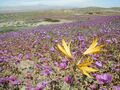 Desert in bloom
 -
 Llamas in the desert
 -
 Rainbow Valley


The geology of the region has four metallogenetic belts where deposits of valuable metals are found. From west to east these belts are the Atacama Fault System (copper and iron), the Inca de Oro Belt (silver, gold), the West Fissure System (copper) and lastly the Maricunga Belt (gold) close to the Argentine border.[8] The Chilean Iron Belt largely follows the Atacama Fault System.[9][10]
Economy
Mining accounts for 41%[11] of the region's GDP and 90% of its exports.[citation needed] Moreover, various geological surveys have identified new deposits.[citation needed] In Atacama Region medium and small-scale mining has a larger share of mining properties relative to large-scale mining that is dominant in the more northern regions of Tarapacá and Antofagasta.[12] The region's mining activity is centered on copper mining, but it host most of Chile's iron and gold mines. In Atacama Region there are numerous small-scale mines, which sell their output to ENAMI (the national mining company) for processing at its Paipote smelter. The region's main copper deposit is Candelaria, which produces around 200,000 tonnes per year and is controlled by Phelps Dodge, an international corporation.[needs update] The next in size is El Salvador, owned by CODELCO, with an annual output of around 81,000 tonnes. Both mines export through the port of Chañaral.[citation needed]
Over recent decades, fresh fruit also emerged as regional export item, when the Copiapó and Huasco valleys joined Chile’s fruit-growing boom. They enjoy a comparative advantage because, thanks to the sunny climate, fruit ripens earlier than in the rest of the country and reaches northern hemisphere markets first. Grapes are the main crop and, on a smaller scale, olives, tomatoes, peppers, onions, broad beans, citrus fruits, nectarines, apricots, oregano, and flowers. The region's organic wealth, its clear waters and sheltered bays, together with its entrepreneurial experience, favor the development of aquaculture. Species produced include the northern scallop, Japanese and Chilean oysters, abalone, turbot, algae, and different varieties of mussels. Other products with more value added include boned fish fillets, smoked and salted fish, roe, and fishburgers.
The unique weather conditions in the Atacama Desert, with extremely rare cloudy days, are ideal for solar power generation.[13] Many PV and CSP plants are being built in this area.[13]
See also
- Flag of Atacama
References
- ↑ "Región de Atacama" (in es). Library of National Congress. https://www.bcn.cl/siit/nuestropais/nuestropais/region3/.
- ↑ "Población censada por sexo y edad en grupos quinquenales" (in Spanish). https://censo2024.ine.gob.cl/wp-content/uploads/2025/03/D1_Poblacion-censada-por-sexo-y-edad-en-grupos-quinquenales.xlsx.
- ↑ Regions and Cities > Regional Statistics > Regional Economy > Regional GDP per Capita, OECD.Stats.
- ↑ "Sub-national HDI - Area Database - Global Data Lab" (in en). https://hdi.globaldatalab.org/areadata/shdi/.
- ↑ (in Spanish) Chile: Ciudades, pueblos, aldeas y caseríos, National Statistics Institute, March 2019, https://geoarchivos.ine.cl/File/pub/Cd_Pb_Al_Cs_2019.pdf, retrieved October 28, 2025
- ↑ Comisión Verdad Histórica y Nuevo Trato con los Pueblos Indígenas (2008). Informe de la Comisión Verdad Histórica y Nuevo Trato con los Pueblos Indígenas. Santiago de Chile. pp. 45-47. https://www.memoriachilena.gob.cl/602/articles-122901_recurso_2.pdf.
- ↑ Teresa Moreno and Wes Gibbons. 2007
- ↑ Palacios, C.M.; Townley, B.C.; Lahsen, A.A.; Egafia, A.M. (1993). "Geological development and mineralization in the Atacama segment of the South American Andes, northern Chile (26°15′–27°25′S)". Geologische Rundschau 82: 652–662. doi:10.1007/BF00191492. https://link.springer.com/article/10.1007/BF00191492.
- ↑ Simon, Adam C.; Knipping, Jaayne; Reich, Martin; Barra, Fernando; Deditius, Artur P.; Bilenker, Laura; Childress, Tristan (2018). "Kiruna-Type Iron Oxide-Apatite (IOA) and Iron Oxide Copper-Gold (IOCG) Deposits Form by a Combination of Igneous and Magmatic-Hydrothermal Processes: Evidence from the Chilean Iron Belt". in Arribas R., Antonio M.. Metals, Minerals, and Society. Society of Economic Geologists Special Publication. 21. pp. 89–114. doi:10.5382/SP.21. ISBN 9781629493084.
- ↑ Travisany, Vinicio; Henríquez, Fernando; Nyström, Jan Olov (1995). "Magnetite lava flows in the Pleito-Melon District of the Chilean iron belt". Economic Geology 90 (2): 438–444. doi:10.2113/gsecongeo.90.2.438. Bibcode: 1995EcGeo..90..438T.
- ↑ (in es) Distritos productivos para el desarrollo de la minería chilena (Report). Centro de Estudios y Documentación Mineros de SONAMI. 2025. https://www.sonami.cl/v2/publicaciones/distritos-productivos-desarrollo-mineria-chilena/.
- ↑ Ulloa Urrutia, Alfie; Contreras Biekert, José Luis; Gana Aravena, Joaquín; Miranda Toledo, Rodrigo; Chauveau Gerber, Paul; Villalobos Valenzuela, Fernando; Farías Soto, Javiera (2017) (in Spanish). Productividad en la Gran Minería del Cobre. Comisión Nacional de Productividad. p. 283. ISBN 978-956-7725-08-3.
- ↑ 13.0 13.1 Watts, Jonathan (22 December 2015). "Desert tower raises Chile's solar power ambition to new heights". The Guardian. https://www.theguardian.com/environment/2015/dec/22/desert-tower-raises-chiles-solar-power-ambition-to-new-heights.
- Teresa Moreno and Wes Gibbons. 2007. The geology of Chile, Geological Society of London, 414 pages
External links
- Gobierno Regional de Atacama Official website Script error: The function "in_lang" does not exist.
Template:Communes in Atacama Region Template:Atacama Region rivers and lakes Template:Regions of Chile
 |  |
