Place:Bukoba
Bukoba ( Pronunciation (help·info)) is a town with a population of 144,938 (2022 census),[1] situated in the northwest of Tanzania on the south-western shores of Lake Victoria. It is the capital of the Kagera region, and the administrative seat for Bukoba Urban District, and is home to Kaitaba Stadium
The town is served by Bukoba Airport and regular ferry connections to and from Mwanza, as well as roads to Uganda's Rakai District for cross-border commuters. Plans are underway for a standard gauge railway[2] to Uganda.
History
Colonial period
The town of Bukoba was founded in 1890 by Emin Pasha as the first German military station on Lake Victoria.[3]: 45 The town was founded in the territory of the Lesser Kyamutwara chiefdom. Its chief, Mukotani, was hospitable to the Germans and directed them against his rivals: Kayoza of Bugabo and Mutatembwa of Kiziba. After Emin raided Bugabo, Kayoza agreed to send support for the station's construction.[4]: 105 Following unrest in neighbouring Uganda, the town received fleeing Catholic missionaries on February 1892.[3]: 45–46 The town was developed into a port through which grain, hides, and ivory passed.[3]: 49–54 Riots broke out during the 1905–1907 Maji Maji Rebellion; they were quickly suppressed.[3]: 84 As part of a series punitive reprisals, Chief Ntare of the Karagwe Kingdom was hanged on a tree in Bukoba.[4]: 253 [5] The Germans constructed a 54 m2 (65 sq yd) fort in 1901.[6]: 14 By 1914, Bukoba hosted one of three transmission stations in German East Africa, alongside Dar es Salaam and Mwanza.[7] During the East African campaign in World War I, the town was sacked by the British on 2 June 1915.[6]: 14 The British launched another raid on 21–23 June, launching attacks from Kisumu. Pillaging and rape were reported to be widespread, and the town was left abandoned after the attacks.[7] After the war, German East Africa was transferred to British control in the 1919 Paris Peace Conference.[4]: 246
Post-independence
In the initial actions of the Uganda–Tanzania War, Bukoba was bombed by Ugandan MiG aircraft on 18 October 1978, spreading panic but causing little destruction.[8]: 54 Another bombing was attempted on 27 October; most bombs landed in forests or Lake Victoria, but one narrowly missed Bukoba's hospital.[8]: 59 [9]: 25 Civilians began to flee the town, and by the following morning Bukoba was mostly abandoned.[8]: 59–60
On 10 September 2016, a magnitude 5.9 earthquake struck east-northeast of Bukoba.[10] Shaking of an estimated MMI IV intensity was felt, and the earthquake destroyed 840 houses and seriously damaged a further 1,264 in the town. At least 19 people were killed and 253 were injured.[10][11]
Geography
Situated on the south-western shores of Lake Victoria, Bukoba lies only 1 degree south of the Equator.
Bukoba is situated on the south-western shores of Lake Victoria in the north-western region of Tanzania bordering Uganda. The regional capital and Kagera's biggest town is the gateway to the region.
It boasts a white sandy beach, a large market,[12] a port[13] tennis courts[14] and a swimming pool.[14] It has 13 banks,[15] 5 of which take VISA cards in the ATM.
Bukoba Town itself has the status of a municipal Council. It has a municipal Director and other local government officials like other district councils in the region.
Climate
Bukoba has an upland tropical monsoon climate (Köppen Amb, because every month has a normal mean temperature of between 18 °C and 22 °C) although it is milder than most climates with that classification due to its altitude. It can sometimes get cool especially in the evenings during the two rainy seasons, but never as cold as the winter season in Europe.[16] Script error: No such module "weather box".
Script error: No such module "weather box".
Economy
Kagera's Regional Commissioner resides and has his head office in The Bukoba Central Business District.[12]
Bukoba is the leading district in Tanzania with a high percentage of people with middle-class incomes. The percentage of people living under the poverty line is the lowest in the country. Bukoba has a new mall named Bakwata Complex that will start operation in September 2024.
The town is flat, compact, and surrounded by hills. The town has a bus stand,[19] an airport,[20] and a port.[21] A ferry used to travel from Bukoba via Kemondo Bay Port to Mwanza on Monday, Wednesday and Friday nights, and soon a newly built ship, the second largest lake ship in Africa, will make ferry voyages to Bukoba daily.[19]
Utilities
Bukoba is served by the National Electric Utility Company TANESCO.[22]
Transport
Bus
A bus[23] leaves for Kampala at 7 am every day (about 6 hours) and from Kampala for Bukoba at 11 am every day.
Ports
Bukoba Port, located about 3 km (1.9 mi) from the town's centre, is the second-largest Tanzanian port on Lake Victoria after the ports at Mwanza. It handles general loose cargo and passengers, with a designed capacity of 9,500 tonnes of cargo per month. It has an 85 m (279 ft) long main berth and two shorter berths.[24]: 7 The port is owned and operated by the Tanzania Ports Authority.[24][13] It has passenger service to Mwanza North Port.[24]: 7
Air

Bukoba Airport is located south east of the city. The address on Sokoine Road.[20]
Auric Air[25] flies three times a day to Mwanza. In 2010 the airport[26] was extended as more flights were expected in line with capacity growth milestones of The Air Terminal reviewed after published reports every quarter of the year.[27] Air Tanzania (ATCL) also have scheduled flights to Bukoba throughout the week with connecting flights through Mwanza to Dar es Salaam.
Sports
Bukoba is represented in the Tanzanian Premier League[28] by football club Kagera Sugar. It is the home to several charities - including SHARE in Africa and Jambo Bukoba. Both are focused on the educational sector.
The Kaitaba Stadium[29] is also found in south east of Bukoba on Jamhuri Road. The stadium has the capacity of 15000 people and supports football games day and night.
Sister cities
 Nykøbing Mors
Gallery
-
 The Mater Misericordiae Church.
-
 MV Victoria (1959) at Port of Bukoba
-
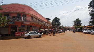 Street in Bukoba


References
- ↑ "Tanzania: Regions and Cities - Population Statistics, Maps, Charts, Weather and Web Information". https://www.citypopulation.de/en/tanzania/cities/.
- ↑ "Home". http://www.mwtc.go.tz/.
- ↑ 3.0 3.1 3.2 3.3 Brode, Heinrich (1911). British and German East Africa: Their Economic and Commercial Relations. E. Arnold.
- ↑ 4.0 4.1 4.2 Iliffe, John (1979). A Modern History of Tanganyika (1 ed.). Cambridge University Press. doi:10.1017/cbo9780511584114.010. ISBN 978-0-521-22024-8. https://www.cambridge.org/core/product/identifier/9780511584114/type/book.
- ↑ "The good, the bad and the ugly of the German colonial legacy" (in en). 2023-11-09. https://www.thecitizen.co.tz/tanzania/oped/the-good-the-bad-and-the-ugly-of-the-german-colonial-legacy-4427522.
- ↑ 6.0 6.1 Joelson, Ferdinand Stephen (1928). Eastern Africa To-day: An Intimate Description of Kenya Colony, Tanganyika Territory, Uganda, Northern Rhodesia, Nyasaland, Zanzibar, and British Somaliland, with Notes on the Sudan and Portuguese East Africa. East Africa.
- ↑ 7.0 7.1 Strachan, Hew (2004). The First World War in Africa. Oxford: Oxford University Press. ISBN 978-0-19-925728-7.
- ↑ 8.0 8.1 8.2 Avirgan, Tony; Honey, Martha (1983). War in Uganda: The Legacy of Idi Amin. Dar es Salaam: Tanzania Publishing House. ISBN 978-9976-1-0056-3.
- ↑ Cooper, Tom; Fontanellaz, Adrien (2015). Wars and Insurgencies of Uganda 1971–1994. Solihull: Helion & Company Limited. ISBN 978-1-910294-55-0.
- ↑ 10.0 10.1 "M5.9 – 27 km ENE of Nsunga, Tanzania". United States Geological Survey. September 10, 2016. https://earthquake.usgs.gov/earthquakes/eventpage/us10006nkx#executive. Retrieved September 10, 2016.
- ↑ "Significant Earthquake Information". NCEI. https://www.ngdc.noaa.gov/hazel/view/hazards/earthquake/event-more-info/10197.
- ↑ 12.0 12.1 "Jamhuri ya Muungano wa Tanzania". http://www.mit.go.tz/.
- ↑ 13.0 13.1 "Lake Victoria Ports". Tanzania Ports Authority. https://www.ports.go.tz/index.php/en/ports/lake-victoria-ports.
- ↑ 14.0 14.1 "Ministry of Information, Culture, Arts and Sports". http://www.habari.go.tz/.
- ↑ "Bank of Tanzania (BOT): Home Page". https://www.bot.go.tz/.
- ↑ "National and Local Weather Radar, Daily Forecast, Hurricane and information from The Weather Channel and weather.com" (in en-US). https://weather.com/.
- ↑ "Bukoba Climate Normals 1991–2020". World Meteorological Organization Climatological Standard Normals (1991–2020). National Oceanic and Atmospheric Administration. https://www.nodc.noaa.gov/archive/arc0216/0253808/1.1/data/0-data/Region-1-WMO-Normals-9120/Tanzania/CSV/BUKOBA_63729.csv.
- ↑ "Klimatafel von Bukoba / Tansania" (in German). Baseline climate means (1961-1990) from stations all over the world. Deutscher Wetterdienst. http://www.dwd.de/DWD/klima/beratung/ak/ak_637290_kt.pdf. Retrieved 22 May 2016.
- ↑ 19.0 19.1 "Home | Ministry of Works, Transport and Communications". http://www.mwtc.go.tz/.
- ↑ 20.0 20.1 "Tanzania Airports Authority". http://www.taa.go.tz/.
- ↑ "Port of BUKOBA (TZ BKZ) details - Departures, Expected Arrivals and Port Calls | AIS MarineTraffic" (in en). https://www.marinetraffic.com/en/ais/details/ports/19593?name=BUKOBA&country=Tanzania.
- ↑ "TANESCO - Welcome to TANESCO website". http://www.tanesco.co.tz/.
- ↑ "Welcome to SUMATRA website". http://www.sumatra.go.tz/.
- ↑ 24.0 24.1 24.2 "Report on the Assessment of Level of Service Delivery Across the Inland Waterways in the Facilitation of Shipping and Trade on Lake Victoria" (in en). Intergovernmental Standing Committee on Shipping (MOESNA). June 2022. https://moesna.org/wp-content/uploads/2025/05/Level-of-Service-Lake-Victoria1.pdf. Retrieved 2026-07-29.
- ↑ "Auric Air Services Ltd". https://www.auricair.com/.
- ↑ "Tanzania Airports Authority". http://www.taa.go.tz/.
- ↑ "Home | Ministry of Works, Transport and Communications". http://www.mwtc.go.tz/.
- ↑ "FIFA". https://www.fifa.com/.
- ↑ "bukoba sports". http://www.bukobasports.com/.
External links
Template:Districts of Kagera [ ⚑ ] 1°20′S 31°49′E / 1.333°S 31.817°E
 |  |


