Place:Hīt
Hīt هيت | |
|---|---|
City | |
 Hit in 2004 | |
 Hīt | |
| Coordinates: [ ⚑ ] : 33°38′42″N 42°49′35″E / 33.645°N 42.82639°E | |
| Country | |
| Province | Al-Anbar |
| District | Hīt District |
| Population (2013) | |
| • Total | 95,800 |
| Time zone | UTC+3 (GMT+3) |
| Postal code | 31007 |
| Ancient name | Is |
Hīt, also spelled Heet (Arabic: هيت), ancient name Is, is an Iraqi city in Al-Anbar province. Hīt lies northwest of Ramadi, the provincial capital.
On the Euphrates River, Hīt is a small walled town built on two mounds on the site of the ancient city of Is. In ancient times, the town was known for its bitumen wells, which were used as far back as 3,000 years ago, to include building of Babylon and for caulking boats. Hīt also became a frontier fortress for Assyria. Now, Hīt is a marketplace for agricultural produce and oil pipelines to the Mediterranean Sea cross the Euphrates there. It was regarded as the head of navigation on the river before the decline in river traffic.[1]
In October 2014, the city had fallen to the Islamic State of Iraq and the Levant, but was recaptured after a military offensive by the Iraqi Army in April 2016.[2][3]
Climate
In Hīt, there is a desert climate. Most rain falls in the winter. The Köppen-Geiger climate classification is BWh. The average annual temperature in Hīt is 21.9 °C (71.4 °F). About 115 mm (4.53 in) of precipitation falls annually.
Script error: No such module "weather box".
Gallery
-
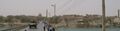 Hit, Iraq, 2004
 -
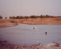 Kubaisa Oasis, 2003

References
- ↑ "Hīt". The New Encyclopædia Britannica. V. Chicago: Encyclopædia Britannica, Inc. 1980. p. 66.
- ↑ http://america.aljazeera.com/articles/2014/12/13/isil-al-wafa-attack.html
- ↑ agencies, The New Arab &. "Iraqi forces recapture key town from IS militants" (in en). https://www.alaraby.co.uk/english/news/2016/4/14/iraqi-forces-recapture-key-town-from-is-militants.
 |
