Place:Kfarhata
From HandWiki
Kfarhata كفرحاتا | |
|---|---|
City | |
 Kfarhata Location within Lebanon | |
| Coordinates: [ ⚑ ] : 34°17′0″N 35°45′0″E / 34.283333°N 35.75°E | |
| Country | |
| Governorate | North Governorate |
| District | Koura District |
| Elevation | 170 m (560 ft) |
| Time zone | UTC+2 (EET) |
| • Summer (DST) | UTC+3 (EEST) |
| Dialing code | +961 |
Kfarhata (also known as Kfar Hata or Kafrhata, Arabic: كفرحاتا) is a village located in the Koura District in the North Governorate of Lebanon. It is one of the 52 towns of El-Koura, situated at the southern region of this district, at the other side of Al-Kateh (The cutter); a shallow but wide valley, separating a group of 6 towns from the gigantic El-Koura olive plains. In 1953, Kfar Hata had a population of 590 living in 64 households.[1]
The population is Greek Orthodox and Maronite.[2]
Although the mountainous profile of this town, the olive trees cultivation is equally successful and popular, with high quality of olive oil, extracted with the traditional Koranian cold technique.
-
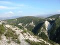
 Poster El-koura "Cutter". Western view
 -
 Poster El-koura "Cutter". Eastern view


See also
- Amioun
- Koura District
References
- ↑ Sawaya, Salah Michel (March 1953). Household Income and Expenditure in Al-Kura, Lebanon (PDF). Scholarworks (M.A.). Beirut, Lebanon: Economics Dept., American University of Beirut, Lebanon. hdl:10938/3411. Archived from the original (PDF) on 24 March 2023. Retrieved 2023-03-24.
- ↑ "Municipal and ikhtiyariah elections in Northern Lebanon". The Monthly. March 2010. p. 23. http://www.localiban.org/IMG/pdf/iiMonthly-Municip-Mar10-E92.pdf.
External links
- Kfar Hata, Localiban
 |  |
