Place:Miarinarivo
From HandWiki
Miarinarivo | |
|---|---|
 Miarinarivo | |
| Coordinates: [ ⚑ ] 18°57′39″S 46°54′00″E / 18.96083°S 46.9°E | |
| Country | |
| Region | Itasy |
| District | Miarinarivo |
| Area | |
| • Land | 17.9 km2 (6.9 sq mi) |
| Population (2018)census | |
| • Total | 13,109 |
| • Ethnicities | Merina |
| Time zone | UTC3 (EAT) |
| Postal code | 117 |
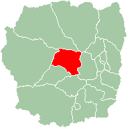
Miarinarivo is a city (commune urbaine) in Itasy Region, in the Central Highlands of Madagascar .
Miarinarivo is located at 100 km (62 mi) of Antananarivo and is the capital of Itasy Region as well as of its district. It is crossed by the National Road 1 that leads from Antananarivo to Tsiroanomandidy.[1]
Education
In Miarinarivo are situated:[2]
- 6 primary schools with 2000 pupils
- 4 secondary schools with 1400 pupils
- 4 Lycée with 900 students
Sports
Football/Soccer
The local club CNaPS Sport is the best football club in the city. The club has been 7 times Malagasy champions, 3 times Malagasy cup champions and Malagasy super-cup champions once.
Religion
- FJKM - Fiangonan'i Jesoa Kristy eto Madagasikara (Church of Jesus Christ in Madagascar)
- FLM - Fiangonana Loterana Malagasy (Malagasy Lutheran Church)
- Roman Catholic Church (Katedraly Kristy Mpanjaka (Cathedral of Christ the King)).[3]
References
 |


