Earth:Bonneterre Formation
| Bonneterre Formation Stratigraphic range: Guzhangian (Dresbachian) ~501–497 Ma | |
|---|---|
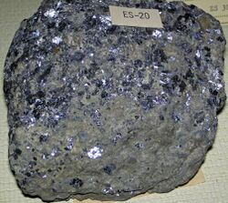
 Galena in Bonneterre Dolomite (Upper Cambrian; Missouri) | |
| Type | Formation |
| Underlies | Davis Formation |
| Overlies | Lamotte Sandstone[1] |
| Lithology | |
| Primary | Dolomite |
| Other | Shale, limestone, sandstone[2] |
| Location | |
| Coordinates | [ ⚑ ] : 37°38′10″N 90°34′41″W / 37.636°N 90.578°W |
| Paleocoordinates | [ ⚑ ] 22°54′S 86°30′W / 22.9°S 86.5°W |
| Region | Illinois, Minnesota & Missouri |
| Country | |
| Lua error in Module:Location_map/multi at line 27: Unable to find the specified location map definition: "Module:Location map/data/Missouri" does not exist. | |
The Bonneterre Formation is an Upper Cambrian geologic formation which outcrops in the St. Francois Mountains of the Missouri Ozarks. The Bonneterre is a major host rock for the lead ores of the Missouri Lead Belt.
The Bonneterre Formation lies conformably on the Lamotte Sandstone and in places lies directly on the Proterozoic igneous core of the mountains. The Bonneterre is conformably overlain by the Davis Formation. In the outcrop area the Bonneterre has an average thickness of 375 to 400 feet. It is present in the subsurface throughout Missouri and has a maximum recorded thickness of 1580 feet under Pemiscot County in the Missouri Bootheel.[2]
The formation is dominantly dolomite with areas or layers of pure limestone. A shaley or glauconitic zone occurs in the lower portion and the base contains sand and conglomerate or breccia where the formation overlaps the Lamotte and lies directly on the granite of the mountain core.[2]
Fossil content
The formation has provided fossils of:[3]
Monoplacophora
- Hypseloconus bonneterrense[4]
- Irondalia
- I. irondalensis[5]
- Kirengella washingtonense[4]
- Ulrichoconus
- U. bonneterrense[5]
Trilobites
- Kingstoniidae
- Blountia sp.[4]
- Tricrepicephalidae
Gastropods
- Tropidodiscidae
See also
- List of fossiliferous stratigraphic units in Missouri
- List of fossiliferous stratigraphic units in Minnesota
- List of fossiliferous stratigraphic units in Illinois
- Paleontology in Illinois
- Paleontology in Minnesota
- Paleontology in Missouri
- Minaret Formation
References
- ↑ Thompson, Thomas L., 2001, Lexicon of Stratigraphic Nomenclature in Missouri, Missouri Department of Natural Resources, Division of Geology and Land Survey, Report of Investigation Number 73, p 37
- ↑ 2.0 2.1 2.2 Howe, W. B. and J. W. Koenig, The Stratigraphic Section in Missouri, Missouri Geological Survey, 1961, pp. 15-18
- ↑ Bonneterre Formation at Fossilworks.org
- ↑ 4.0 4.1 4.2 4.3 4.4 Stinchcomb, 1975
- ↑ 5.0 5.1 Stinchcomb & Angeli, 2002
Bibliography
- Stinchcomb, Bruce, and Nicholas Angeli. 2002. New Cambrian and Lower Ordovician monoplacophorans form the Ozark Uplift, Missouri. Journal of Paleontology 76. 965-974.
- Stinchcomb, B. L. 1975. Paleoecology of two new species of Late Cambrian Hypseloconus (Monoplacophora) from Missouri. Journal of Paleontology 49. 416–421.
 |

