Astronomy:Gambart (crater)
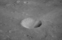
 Lunar Orbiter 4 image | |
| Diameter | 25 km |
|---|---|
| Depth | 1.1 km |
| Colongitude | 15° at sunrise |

.jpg)
Gambart is a small lunar impact crater on the Mare Insularum, near the central region of the Moon. It is named after French astronomer Jean-Félix Adolphe Gambart.[1] It can be located to the south-southeast of the prominent ray crater Copernicus. In the past, the floor of Gambart has been flooded with lava, leaving a relatively flat surface surrounded by a smooth but somewhat polygon-shaped outer rim. To the southwest of Gambart is an area of hilly terrain deposited from ejecta during the Mare Imbrium impact, known as the Fra Mauro Formation.
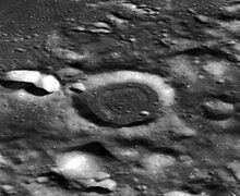
The smaller Gambart C crater is located to the northeast of Gambart itself. Roughly between Gambart and Gambart C is a lunar dome, a type of shield volcano. The Surveyor 2 probe crashed to the northeast of Gambart C.
Satellite craters
By convention these features are identified on lunar maps by placing the letter on the side of the crater midpoint that is closest to Gambart.
| Gambart | Latitude | Longitude | Diameter |
|---|---|---|---|
| A | 1.0° N | 18.7° W | 12 km |
| B | 2.2° N | 11.5° W | 11 km |
| C | 3.3° N | 11.8° W | 12 km |
| D | 3.4° N | 17.7° W | 6 km |
| E | 1.0° N | 17.2° W | 4 km |
| F | 0.1° N | 16.9° W | 5 km |
| G | 1.9° N | 12.0° W | 6 km |
| H | 3.2° N | 10.6° W | 4 km |
| J | 0.7° S | 18.2° W | 7 km |
| K | 3.9° N | 14.2° W | 4 km |
| L | 3.3° N | 15.3° W | 4 km |
| M | 5.4° N | 11.7° W | 4 km |
| N | 0.5° S | 14.9° W | 5 km |
| R | 0.6° S | 20.8° W | 4 km |
| S | 0.1° S | 13.2° W | 3 km |
Images
-
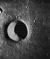
 Lunar Orbiter 4 image of Gambart A
 -
 Oblique Apollo 12 image of Gambart A
 -
 Lunar Orbiter 2 image of Gambart C
 -
 Lunar Orbiter 3 image of Gambart J


References
- ↑ "Gambart (crater)". Gazetteer of Planetary Nomenclature. USGS Astrogeology Research Program.
- Andersson, L. E.; Whitaker, E. A. (1982). NASA Catalogue of Lunar Nomenclature. NASA RP-1097.
- Bussey, B.; Spudis, P. (2004). The Clementine Atlas of the Moon. New York: Cambridge University Press. ISBN 978-0-521-81528-4.
- Cocks, Elijah E.; Cocks, Josiah C. (1995). Who's Who on the Moon: A Biographical Dictionary of Lunar Nomenclature. Tudor Publishers. ISBN 978-0-936389-27-1. https://archive.org/details/isbn_9780936389271.
- McDowell, Jonathan (July 15, 2007). "Lunar Nomenclature". Jonathan's Space Report. http://host.planet4589.org/astro/lunar/.
- Menzel, D. H.; Minnaert, M.; Levin, B.; Dollfus, A.; Bell, B. (1971). "Report on Lunar Nomenclature by the Working Group of Commission 17 of the IAU". Space Science Reviews 12 (2): 136–186. doi:10.1007/BF00171763. Bibcode: 1971SSRv...12..136M.
- Moore, Patrick (2001). On the Moon. Sterling Publishing Co.. ISBN 978-0-304-35469-6. https://archive.org/details/patrickmooreonmo00patr.
- Price, Fred W. (1988). The Moon Observer's Handbook. Cambridge University Press. ISBN 978-0-521-33500-3.
- Rükl, Antonín (1990). Atlas of the Moon. Kalmbach Books. ISBN 978-0-913135-17-4.
- Webb, Rev. T. W. (1962). Celestial Objects for Common Telescopes (6th revised ed.). Dover. ISBN 978-0-486-20917-3. https://archive.org/details/celestialobjects00webb.
- Whitaker, Ewen A. (1999). Mapping and Naming the Moon. Cambridge University Press. ISBN 978-0-521-62248-6.
- Wlasuk, Peter T. (2000). Observing the Moon. Springer. ISBN 978-1-85233-193-1.
External links
- Gambart at The Moon Wiki
- Lunar Orbiter 1 photos 134 and 135, showing part of Gambart crater and the area to the northwest
Related articles
- Wood, Chuck (March 20, 2007). "3.8 Billion Years of History". Lunar Photo of the Day. http://www.lpod.org/?m=20070320.
- Wood, Chuck (July 25, 2008). "Extreme Makeover". Lunar Photo of the Day. http://lpod.wikispaces.com/July+25%2C+2008. - Gambart-type craters
- Wood, Chuck (October 3, 2008). "Ups and Downs". Lunar Photo of the Day. http://lpod.wikispaces.com/October+3%2C+2008. - Gambart B, C and environs
 |  |

