Earth:Ata Caldera
| Ata Caldera | |
|---|---|
 | |
| Highest point | |
| Peak | Mount Kaimon, [ ⚑ ] 31°10′48″N 130°31′42″E / 31.18°N 130.52833°E |
| Elevation | 924 m (3,031 ft) |
| Coordinates | [ ⚑ ] : 31°24′N 130°38′E / 31.40°N 130.64°E [3] |
| Dimensions | |
| Length | 25 km (16 mi) NS |
| Width | 15 km (9.3 mi) EW |
| Naming | |
| Native name | [阿多カルデラ (Japanese)] Error: {{Native name}}: missing language tag (help) (language?) |
| Geography | |
Kagoshima, Japan | |
| Country | Japan |
| State | Kagoshima Prefecture |
| Region | Ibusuki, Kagoshima, Kimotsuki District, Tarumizu |
| Geology | |
| Age of rock | Pleistocene (240,000 years ago) onwards |
| Mountain type | Caldera Somma volcano |
| Last eruption | 885 CE[3] |
Ata Caldera (阿多カルデラ Ata karudera), containing the Ata North Caldera, Mount Kaimon and Ikeda Caldera amongst other volcanoes, is a massive, ill defined, mostly submerged volcanic caldera associated with the southern portions of Kagoshima Bay.
Geology
The earliest tephra assigned to the volcano, is the widespread on regional sea bed cores, Ata–Torihama tephra (Ata-Th) at 240,000 years before the present.[4]
The caldera contributed to an eruption which has been dated to about 100,000 years before present (range by various techniques mostly fall 100,000 to 109,000) that generated the Ata tephra in southern Japan.[5] This eruption has been assigned a VEI of 7.5 and generated over 300 km3 (72 cu mi) of tephra.[6] This is overlaid in some places in Japan by the more recent Mitake No. 1 (On-Pm1) tephra from an eruption in the Mount Ontake area and K-Tz tephra from the Kikai Caldera.[5] There have been many more lesser eruptions.
Structure
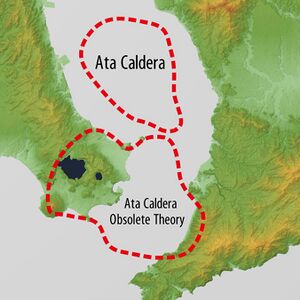
Some of the recent literature separates the caldera into a northern almost completely submerged caldera that generated the Ata tephra and Ata ignimbrite, and a southern caldera which includes the recently active Ikeda Caldera and the Kaimondake stratovolcano in the Ibusuki Volcanic Field. [1] This southern caldera first had the Ata name but is not believed now to be associated with the vents of the major eruption of 100,000 years ago.[7] High resolution Bouguer gravity imaging of Kyushu is consistent with the larger caldera being the Ata North Caldera but suggests it may be centered near the island of Chiringashima, and that the Ata South Caldera is the smaller in size, overlaps it being centred near Yamagawafukumoto district.[2]
The National Catalogue of the Active Volcanoes of Japan (JMA, 2013) included features of the Ibusuki Volcanic Field as part of the Ata post-caldera system.[3] By this definition the single caldera may be a rounded triangle about 30km in length and up to 25km in width,[1] although the usual quoted size is smaller.
Relationships
Immediately adjacent to the north of the caldera is the Sakurajima volcano in the Aira Caldera and further away to the south along what has been termed the Kagoshima Graben[1] is the Kikai Caldera.[8] This alignment was first described by Tadaiti Matumoto in the 1940s.[7] The alignment extends all the way north past Mount Kirishima to intersect the Aso Caldera by gravitational anomaly.[2] The tectonic processes are rather complex in this region where the Okinawa Plate is colliding with the Amur Plate and the Pacific Plate is subducting under both.
References
- ↑ 1.0 1.1 1.2 1.3 "IAVCEI 2013 Scientific Assembly A Guide for Mid-Conference Field Trip". https://fdocuments.in/document/2014-1-21-kirishima-sakurajima-and-kaimondake-on-kyushu-and-several-volcanic.html?page=1.
- ↑ 2.0 2.1 2.2 Shichi, R.; Yamamoto, A.; Kudo, T.; Murata, Y.; Nawa, Kazunari; Komazawa, Masao; Nakada, M.; Miyamachi, H. et al. (2005). "A Gravity Database of Southwest Japan: Application to Bouguer Gravity Imaging in Kyushu District, Southwest Japan". A Window on the Future of Geodesy. International Association of Geodesy Symposia. 128. pp. 236–241. doi:10.1007/3-540-27432-4_40. ISBN 3-540-24055-1. https://www.researchgate.net/publication/251134851.
- ↑ 3.0 3.1 3.2 "Ata |Global Volcanism Program | Smithsonian Institution" (in en). https://volcano.si.edu/volcano.cfm?vn=282070.
- ↑ Ikehara, Ken (2015). "Marine tephra in the Japan Sea sediments as a tool for paleoceanography and paleoclimatology". Progress in Earth and Planetary Science 2 (36): 1-12. doi:10.1186/s40645-015-0068-z. Bibcode: 2015PEPS....2...36I. https://progearthplanetsci.springeropen.com/counter/pdf/10.1186/s40645-015-0068-z.pdf.
- ↑ 5.0 5.1 Okuno, Mitsuru (2019-04-15). "Chronological study on widespread tephra and volcanic stratigraphy of the past 100,000 years". The Journal of the Geological Society of Japan 125 (1): 41–53. doi:10.5575/geosoc.2018.0069. ISSN 1349-9963. https://www.jstage.jst.go.jp/article/geosoc/125/1/125_2018.0069/_article/-char/en.
- ↑ Smith, Victoria C.; Staff, Richard A.; Blockley, Simon P.E.; Ramsey, Christopher Bronk; Nakagawa, Takeshi; Mark, Darren F.; Takemura, Keiji; Danhara, Toru (2013). "Identification and correlation of visible tephras in the Lake Suigetsu SG06 sedimentary archive, Japan: chronostratigraphic markers for synchronising of east Asian/west Pacific palaeoclimatic records across the last 150 ka". Quaternary Science Reviews 67: 121–137. doi:10.1016/j.quascirev.2013.01.026. ISSN 0277-3791. Bibcode: 2013QSRv...67..121S. https://www.sciencedirect.com/science/article/pii/S0277379113000413.
- ↑ 7.0 7.1 Matumoto, Tadaiti (1965-08-28). "Calderas of Kyusyu". Transactions of the Luna Geological Field Conference. https://www.oregongeology.org/pubs/ofr/O-66-01.pdf. Retrieved 2022-09-19.
- ↑ Geshi, N.; Yamada, I.; Matsumoto, K.; Nishihara, A.; Miyagi, I. (2020). "Accumulation of rhyolite magma and triggers for a caldera-forming eruption of the Aira Caldera, Japan". Bulletin of Volcanology 82 (44): 44. doi:10.1007/s00445-020-01384-6. Bibcode: 2020BVol...82...44G. https://link.springer.com/article/10.1007/s00445-020-01384-6.
 |

