Earth:Beerenberg
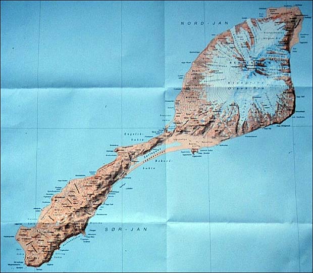
Beerenberg is a stratovolcano dominating the northeastern end of the Norwegian island of Jan Mayen.[1] It is 2,277 m (7,470 ft) high and is the world's northernmost subaerial active volcano and the only active volcano in Norway.[2] The volcano is topped by a mostly ice-filled crater about one kilometre (5⁄8 mile) wide,[3] with numerous peaks along its rim including the highest summit, Haakon VII Toppen, on its western side.
Name
Its name is Dutch for "Bear Mountain" and comes from the polar bears seen there by Dutch whalers in the early 17th century.[4]
Description
The upper slopes of the volcano are largely ice-covered, with several major glaciers including five which reach the sea.[5] The longest of the glaciers is the Weyprecht Glacier, which flows from the summit crater via a breach through the northwestern portion of the crater rim, and extends about 6 km (4 mi) down to the sea.
Geology
Jan Mayen island is a younger surface feature of a 400 km (250 mi) long undersea ridge from the Jan Mayen Microcontinent that rifted off the east Greenland continental margin about 36 million years ago during the Paleocene/Eocene transition.[6] The volcanic island of Jan Mayen formed in the Pleistocene,[7] and is without all the characteristics of a volcanic hotspot,[8]: 76 although the Jan Mayen hotspot has been postulated.[8]: 66
Beerenberg itself is composed primarily of alkali basaltic lava flows with minor amounts of tephra.[6][3] Numerous cinder cones have been formed along slope fissures.[3]
Eruptions
Its most recent eruptions took place in 1970[9] and 1985, both of which were flank eruptions from fissures on the northeast side of the mountain. Other eruptions with historical records occurred in 1732, 1818, and 1851.[3]
| Start Date | End Date | VEI | Comment |
|---|---|---|---|
| 6 January 1985 | 9 January 1985 | 2 | Eruption from fissures on the northern slope.[6] |
| 15 January 1973 | - | 1 | Only timed within ± 45 day period |
| 2 July 1970 | 18 September 1970 | 3 | The eruption end is uncertain ± 182 days |
| 2 July 1851 | - | - | Eruption period is only dated within ± 30 years but definitely erupting on date given |
| 16 April 1818 | - | 3 | Eruption period is only dated within ± 15 days but definitely erupting on date given, VEI size has uncertainty |
| 17 May 1732 | 18 May 1732 | 4 | |
| 1558 | - | - | Eruption was in 1558 or before |
| 1350 | - | - | Radiocarbon dating ± 300 years |
Risks
The main risk is disruption to aviation from a large eruption. There are funded proposals to increase the relevant monitoring capacity.[10]
History
There was an Austrian attempt to reach the summit of Beerenberg, presumably whilst the Austrians had a weather station on the island in 1882–83, but the attempt failed due to poor weather. The first recorded ascent was in the summer of 1921, by an expedition led by Dr. Paul Louis Mercanton, joined by James Wordie, T.C. Lethbridge and three others.[11] The British expedition was taken to the island by the Norwegian meteorological service, which was establishing a wireless station on the island.
See also
- List of volcanoes in Norway
- List of mountains in Norway by prominence
References
- ↑ "Jan Mayen: volcano in the freezer". 25 Aug 2015. http://www.volcanocafe.org/jan-mayen-volcano-in-the-freezer/.
- ↑ "Jan Mayen Expedition 1997 European Volcanological Society". http://www.sveurop.org/gb/menu/fr_menu.htm.
- ↑ 3.0 3.1 3.2 3.3 3.4 "Jan Mayen". Smithsonian Institution. https://volcano.si.edu/volcano.cfm?vn=376010.
- ↑ James Gordon Hayes, The Conquest of the North Pole: Recent Arctic Exploration, p. 222, Taylor & Francis, 1934
- ↑ Jan Mayen Topographic Map
- ↑ 6.0 6.1 6.2 Trønnes, R.G.; Planke, S.; Sundvoll, B.; Imsland, P. (1999). "Recent volcanic rocks from Jan Mayen: Low‐degree melt fractions of enriched northeast Atlantic mantle". Journal of Geophysical Research: Solid Earth 104 (B4): 7153-7168. doi:10.1029/1999JB900007. Bibcode: 1999JGR...104.7153T.
- ↑ Breivik, A.J.; Mjelde R.; Shimamura H.; Murai Y.; Nishimura Y. (2003). "Crustal Structure of the Northern and Southern Jan Mayen Ridge Segments, Norwegian Sea, Based on Ocean Bottom Seismometer Data". American Geophysical Union, Fall Meeting 2003, Abstract #T12D-0492 2003: T12D–0492. Bibcode: 2003AGUFM.T12D0492B.
- ↑ 8.0 8.1 Foulger, Gillian R.; Jurdy, Donna M. (2007). Plates, Plumes, and Planetary Processes. Geological Society of America. pp. 1–997. ISBN 9780813724300. https://books.google.com/books?id=l9a7tIJBYbkC&q=%22jan+mayen%22&pg=PA76. Retrieved 6 June 2026.
- ↑ Sylvester, Arthur Gibbs. "Seismic Search for Magma Chambers Beneath Jan Mayen and Field Inspection of the 1970 Beerenberg Eruption Area". http://www.geol.ucsb.edu/faculty/sylvester/JAN_MAYEN/JMPages/Jan%20Mayen%20text.html.
- ↑ "The Icelandic Met Office receives international grant to strengthen aviation safety in relation to volcanic hazards". Icelandic Meteorological Office. 3 June 2026. https://en.vedur.is/about-imo/news/the-icelandic-met-office-receives-international-grant-to-strengthen-aviation-safety-in-relation-to-volcanic-hazards.
- ↑ Mercanton, P.L. (6 June 1925). "Ascent of Beerenberg, Jan Mayen". Nature 115 (891): 891. doi:10.1038/115891a0. Bibcode: 1925Natur.115Q.891.. https://www.nature.com/articles/115891a0. Retrieved 31 March 2022.
External links
- New Jan Mayen Homepage, including general info, photos, blog, and webcam
- Old Jan Mayen Homepage , including general info, photos, blog, and webcam
- Beerenberg Expedition 2008 Pictures
- Pictures and a map of Beerenberg
- 1970 Beerenberg volcanic eruption captured on film
Template:Ultras of Europe Template:Jan Mayen
 |  |