Earth:Capulin Volcano
| Capulin Volcano National Monument | |
|---|---|
   | |
| Location | Raton-Clayton Volcanic Field, Union County, New Mexico, New Mexico, United States |
| Coordinates | [ ⚑ ] : 36°46′56″N 103°58′12″W / 36.78222°N 103.97°W |
| Area | 793 acres (321 ha)[1] |
| Elevation | 2,494 m (8,182 ft) |
| Max. elevation | 8,182 |
| Authorized | August 9, 1916 |
| Visitors | 89,489 (in 2025)[2] |
| Governing body | Department of the Interior |
| Website | Capulin Volcano National Monument |
Capulin Volcano National Monument is a U.S. National Monument located in northeastern New Mexico, 30 miles (48 km) east of Raton. It encompasses around 800 acres (320 ha) of land that includes an extinct cinder cone volcano and is part of the Raton-Clayton volcanic field.[4] The volcano and surrounding area was established as a national monument by president Woodrow Wilson in 1916.[5]
Geology
Geological history
The Capulin Volcano lies in between the 8,000 square miles (21,000 km2) Raton-Clayton Volcanic Field (RCVF). Volcanic eruption started around 9 million years ago and continued intermittently until around 37,000 years ago.[6] The field itself is between the cities of Raton amd Clayton which it derivies its name from.[7]
Advanced dating techniques from the mid 1990s estimate the eruption of Capulin happened approximately 60,000 years ago over the course of several weeks to several years. More precise argon-argon dating placed the age of eruption at around 54,200 ±1,800 years before present.[7]
During the eruption, the cone reached a height of 500 metres (1,600 ft) from intermittent and discrete Strombolian bursts. Winds from the Southwest to West causing more materials to accumulate on the east flank and making the cone asymmetrical. Lava flowed afterwards around the weak spot of the base or "boca" (Spanish for mouth), spreading over more than 15 square miles (39 km2), rather than flowing out the crater of the cinder cone. Vegetation quickly grew after the lava stopped which helped retain the original look of the volcano.[7][8]
Geologic Features
The crater has a diameter around 1,450 feet (440 m) with a base circumference of 4 miles (6.4 km) and a maximum depth at 415 feet (126 m).[4] Around 100 feet (30 m) of erosion has occurred since the eruption ended. Spatter deposits are sprinkled around the base of the volcano in addition to prominent pressure ridges. The rims of the volcano are asymmetrical, with the west side lower than the east side.
Designation as National Monument
The land surrounding Capulin was heavily used for resource exploitation. In December 1890, Inspector W.D. Harlan visited the site and wrote a letter to the General Land Office which read:[9]: 47
“Prof. Dana of Yale College, who is regarded as the best authority in this country on Volcanoes says that “Capulin” is the most perfect specimen of extinct Volcanoes in North America.”
With the endorsement of the Secretary of the Interior, John Willock Noble, the US withdrew from “settlement, entry or other disposition under any of the public land laws until such time as Congress may see fit,” as quoted from the General Land Office.[9]: 47 [10]
Later on August 9, 1916, President Woodrow Wilson declared Capulin as a National Monument a decade after the Antiquities Act. A week afterwards, Wilson established the National Park Service which has administered the park ever since.[9]: 48, 50
The 87th Congress passed a law to amend a procolamation to "…preserve the scenic and scientific integrity of Capulin Mountain National Monument…" in 1962.[11]
In 1987, Congress changed “Capulin Mountain National Monument” to “Capulin Volcano National Monument,”.[12]
On December 19, 2025, the monument was listed on the National Register of Historic Places[13]
Ecology
.jpg)
The vegetation around Capulin Volcano are apart of the pinyon-juniper woodland, with tree species including pinyon pines, juniper trees ponderosa pines, Rocky Mountain juniper, Gambel oak, quaking aspens and chokecherry.[14] The last one being primarily important due to its Spanish name, Capulin, being used to name the volcano.[10] The surrounding area also include a number of animals like mountain lions, bobcats, American black bears, mule deers, and wild turkeys.[10]
Notable endemic species which reside around the volcano includes the Capulin Alberta Arctic Butterfly, which was found around the rim of the volcano in 1969.[15][16] An endemic plant, the Capulin Goldenrod was also found in 1930 and was identified as a new species found in 1936.[17][18][19]
Gallery
-
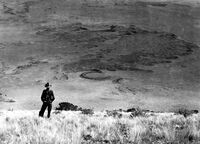 Congealed lava flows, viewed from the top of Capulin Volcano (1909)
 -
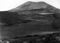 Capulin Volcano, viewed from the west (1916)
 -
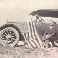 Homer Farr after the completion of the road (1925)


See also
- List of national monuments of the United States
- Black Mesa (Oklahoma)
- Eastern New Mexico
- Johnson Mesa
- Sierra Grande
References
- ↑ "Listing of acreage as of December 31, 2011". Land Resource Division, National Park Service. https://www.nps.gov/subjects/lwcf/upload/NPS-Acreage-12-31-2011.pdf.
- ↑ "NPS Annual Recreation Visits Report". National Park Service. https://irma.nps.gov/Stats/Reports/National.
- ↑ "Capulin Volcano National Monument". https://science.nasa.gov/earth/earth-observatory/capulin-volcano-national-monument-88581/.
- ↑ 4.0 4.1 "Natural Features & Ecosystems". https://www.nps.gov/cavo/learn/nature/naturalfeaturesandecosystems.htm.
- ↑ "Proclamation 1340—Setting Aside the Capulin Mountain National Monument, New Mexico". https://www.presidency.ucsb.edu/documents/proclamation-1340-setting-aside-the-capulin-mountain-national-monument-new-mexico. "Now, Therefore, I, Woodrow Wilson, President of the United States of America, by virtue of the power in me vested by Section 2 of the Act of Congress entitled, "An Act for the Preservation of American Antiquities", approved June 8, 1906 (34 Stat., 225), do proclaim that... under the public land laws, and set apart as the Capulin Mountain National Monument"
- ↑ "Capulin Volcano National Monument". https://geoinfo.nmt.edu/tour/home.cfml?id=67.
- ↑ 7.0 7.1 7.2 "NPS Geodiversity Atlas—Capulin Volcano National Monument, New Mexico". https://www.nps.gov/articles/nps-geodiversity-atlas-capulin-volcano-national-monument-new-mexico.htm.
- ↑ "New Mexico National Monuments : Capulin Volcano". https://newmexiconomad.com/capulin-volcano/.
- ↑ 9.0 9.1 9.2 Hunner, Jon; G. Lael, Shirley (2003). CAPULIN VOLCANO NATIONAL MONUMENT : An Administrative History (Report). Intermountain Cultural Resource Management Professional Paper No. 67. Santa Fe, NM: National Park Service, U.S. Department of the Interior. https://npshistory.com/publications/cavo/adhi.pdf.
- ↑ 10.0 10.1 10.2 10.3 "Volcanic Resources Summary—Capulin Volcano National Monument". https://www.nps.gov/articles/000/volcanic-resources-summary-capulin-volcano-national-monument.htm.
- ↑ "An Act to revise the boundaries of Capulin Mountain National Monument, New Mexico, to authorize acquisition of lands therein, and for other purposes". United States Statutes at Large (U.S. Government Printing Office) 76: 436. September 5, 1962. https://www.congress.gov/87/statute/STATUTE-76/STATUTE-76-Pg436.pdf.
- ↑ "An Act to establish the El Malpais National Monument and the El Malpais National Conservation Area in the State of New Mexico, to authorize the Masau Trail, and for other purposes". United States Statutes at Large (U.S. Government Printing Office) 101: 1547. December 31, 1987. https://www.congress.gov/100/statute/STATUTE-101/STATUTE-101-Pg1539.pdf.
- ↑ "Weekly List 2026 01 02". https://www.nps.gov/subjects/nationalregister/weekly-list-2026-01-02.h.
- ↑ Muldavin, E.; Chauvin, Y.; Neville, T.; Arbetan, P.; Fettes, A.; Kennedy, A.; Arnold, L. (2011). A vegetation classification and map: Capulin Volcano National Monument (Report). Natural Resource Technical Report NPS/SOPN/NRTR 2011/461. Fort Collins, Colorado: National Park Service.
- ↑ "Capulin Alberta Arctic Butterfly". https://npshistory.com/publications/cavo/resource-briefs/alberta-butterfly-2012.pdf.
- ↑ Doneski, Simon M.; Baine, Quinlyn; Ricks, Kelly; Cary, Steven J.; Miller, Kelly B. (2025). "Rediscovery and ecology of the Capulin Mountain Alberta arctic butterfly: informing data collection for rare endemics". bioRxiv 10.1101/2025.10.23.684241.
- ↑ "Capulin Goldenrod". https://www.nps.gov/articles/capulin-goldenrod.htm.
- ↑ "Solidago capulinensis (Capulin Goldenrod)". https://nmrareplants.unm.edu/node/230.
- ↑ "Capulin Goldenrod". https://npshistory.com/publications/cavo/resource-briefs/goldenrod-2012.pdf.
- Sayre, W., & Ort, M. (1999). A Geologic Study of the Capulin Volcano National Monument and surrounding areas, Union and Colfax Counties, New Mexico. New Mexico Bureau of Geology and Mineral Resources. https://geoinfo.nmt.edu/publications/openfile/downloads/500-599/541/ofr_541.pdf
External links
- Official Capulin Volcano National Monument website—National Park Service
- Sangres.com: Information and photos
- Geology Fieldnotes: Capulin Volcano National Monument—National Park Service
Template:Protected areas of New Mexico Template:National Monuments of the United States Template:Mountains of New Mexico
 |


