Earth:Cathedral Cliff
| Cathedral Cliff | |
|---|---|
 Southeast aspect | |
| Highest point | |
| Elevation | 5,810 ft (1,770 m) [1] |
| Prominence | 360 ft (110 m) [1] |
| Parent peak | Table Mesa ( 5,850 ft)[2] |
| Isolation | 1.16 mi (1.87 km) [1] |
| Coordinates | [ ⚑ ] : 36°36′29″N 108°42′26″W / 36.60806°N 108.70722°W [3] |
| Geography | |
| Location | San Juan County, New Mexico, US |
| Parent range | Chuska Mountains[2] Colorado Plateau |
| Topo map | USGS Table Mesa |
| Geology | |
| Age of rock | Oligocene |
| Mountain type | Volcanic plug |
| Type of rock | Volcanic breccia |
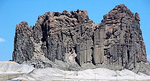
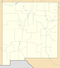
Cathedral Cliff is a 5,810-foot (1,770-meter) elevation volcanic plug located on Navajo Nation land in San Juan County of northwest New Mexico, United States.[3] It is a prominent landmark set alongside U.S. Route 491, approximately 13 miles south of the community of Shiprock, New Mexico. Cathedral Cliff is one of the phreatomagmatic diatremes of the Four Corners area, and with significant relief as it rises 400 feet (120 meters) above the high-desert plain.[4] It is situated about 9.5 miles (15.3 km) southeast of Shiprock, the most famous of these diatremes. Cathedral Cliff is set in the northeastern part of the Navajo Volcanic Field, a volcanic field that includes intrusions and flows of minette and other unusual igneous rocks which formed around 30 million years ago during the Oligocene.[5] Its nearest higher neighbor is Table Mesa, one mile to the southwest, and Barber Peak is set 1.5 mile to the southeast.
Geology
Cathedral Cliff is the eroded remnants of a maar-diatreme volcano, formed when rising magma came into contact with country rock saturated with groundwater. The resulting explosive volcanism created a deep volcanic pipe (the diatreme) and a shallow surface crater (the maar). Subsequent erosion has removed 500 to 1,000 meters (1,600 to 3,300 ft) of overlying sediments to expose the deeper diatreme,[6] including the rarely-exposed diatreme-maar transition zone.[7] This has been studied by geologists to gain insights into how maar-diatreme volcanism works. The pipe at this level is a mixture of intact and broken beds of pyroclastic rock deposited at a higher level, which subsequently subsided deeper into the pipe. These were partially destroyed by debris jets later in the eruption.[6]
Climate
According to the Köppen climate classification system, Cathedral Cliff is located in a semi-arid climate zone with cold winters and hot summers.[8] Precipitation runoff from this feature drains into Dead Mans Wash, which is part of the San Juan River drainage basin.
See also
- Rock formations in the United States
References
- ↑ 1.0 1.1 1.2 "Cathedral Cliff - 5,810' NM". https://listsofjohn.com/peak/15473. Retrieved 2020-12-04.
- ↑ 2.0 2.1 "Cathedral Cliff". https://peakvisor.com/peak/cathedral-cliff.html. Retrieved 2020-12-04.
- ↑ 3.0 3.1 "Cathedral Cliff". United States Geological Survey. https://geonames.usgs.gov/apex/f?p=gnispq:3:::NO::P3_FID:887289.
- ↑ Caroline Bélanger and Pierre-Simon Ross, Origin of nonbedded pyroclastic rocks in the Cathedral Cliff diatreme, Navajo volcanic field, New Mexico, Bulletin of Volcanology, 2018
- ↑ Steven C. Semken, The Navajo Volcanic Field, in Volcanology in New Mexico, New Mexico Museum of Natural History and Science Bulletin 18, p. 79, 2001. ISSN 1524-4156
- ↑ 6.0 6.1 Bélanger, Caroline; Ross, Pierre-Simon (July 2018). "Origin of nonbedded pyroclastic rocks in the Cathedral Cliff diatreme, Navajo volcanic field, New Mexico". Bulletin of Volcanology 80 (7): 61. doi:10.1007/s00445-018-1234-0. https://espace.inrs.ca/id/eprint/7657/1/P3379.pdf.
- ↑ Latutrie, Benjamin; Ross, Pierre-Simon (April 2019). "Transition zone between the upper diatreme and lower diatreme: origin and significance at Round Butte, Hopi Buttes volcanic field, Navajo Nation, Arizona". Bulletin of Volcanology 81 (4): 26. doi:10.1007/s00445-019-1285-x. https://espace.inrs.ca/id/eprint/8061/1/P3491.pdf.
- ↑ Peel, M. C.; Finlayson, B. L.; McMahon, T. A. (2007). "Updated world map of the Köppen−Geiger climate classification". Hydrol. Earth Syst. Sci. 11. ISSN 1027-5606.
External links
- Cathedral Cliff aerial video: YouTube
- Weather forecast: National Weather Service
- Cathedral Cliff rock climbing: Mountainproject.com
 |


