Earth:Goolwa Barrages
| Goolwa Barrages | |
|---|---|
 A map showing the location of each of the Goolwa Barrages | |
| Lua error in Module:Location_map at line 522: Unable to find the specified location map definition: "Module:Location map/data/South Australia" does not exist. | |
| Country | Australia |
| Location | Coorong National Park, South Australia |
| Coordinates | [ ⚑ ] : 35°31′43″S 138°48′29″E / 35.52851°S 138.80819°E |
| Purpose | Flood control |
| Status | Operational |
| Construction began | 1935 |
| Opening date | 1940 |
| Built by | Engineering and Water Supply Department |
| Owner(s) | Murray-Darling Basin Authority |
| Operator(s) | SA Water |
| Dam and spillways | |
| Type of dam | Barrage |
| Impounds | River Murray |
| Length | various |
The Goolwa Barrages comprise five tidal barrages in the channels separating Lake Alexandrina from the sea at the mouth of the River Murray, near Template:SAcity, in the Coorong National Park, in South Australia. They were constructed principally to reduce salinity levels in the lower reaches of the River Murray, Lake Alexandrina and Lake Albert, but also to stabilise the river level, for both upstream irrigation and pumping.[1][2]
History
Prior to the construction of the barrages, during periods of low river flow, tidal effects and the intrusion of seawater were felt up to 250 kilometres (160 miles) upstream from the mouth of the River Murray, approximately as far inland as the river port at present-day Swan Reach.[3][4]

From the 1900s, with the advent of large irrigation schemes, landowners along the lower reaches of the river strongly urged for the construction of barrages, primarily to keep the water fresh in the lower reaches of the River Murray, as well as Lake Albert and Lake Alexandrina.
In 1931, the Murray-Darling Basin Commission authorised the construction of five barrages. Work commenced in 1935 and was completed in 1940. South Australia's Engineering and Water Supply Department undertook the project, with costs shared equally by the governments of South Australia, Victoria, New South Wales and the Australian government.
Marine passage
In 2001, the Murray-Darling Basin Commission initiated a program to improve the movement of fish along 2,000 kilometres (1,200 mi) of the River Murray, from the mouth to the Hume Dam. Five fishways were constructed in the Goolwa Barrages in 2002 to allow fish to migrate between saline and freshwater environments. A rock ramp fishway and two vertical slot fishways were constructed at the Tauwitchere Barrage and vertical slot fishways were built at the Goolwa Barrage and Hunters Creek. The fishways also allow freshwater species that inadvertently get washed into the estuary to return to the freshwaters of the lakes.[5]
Description

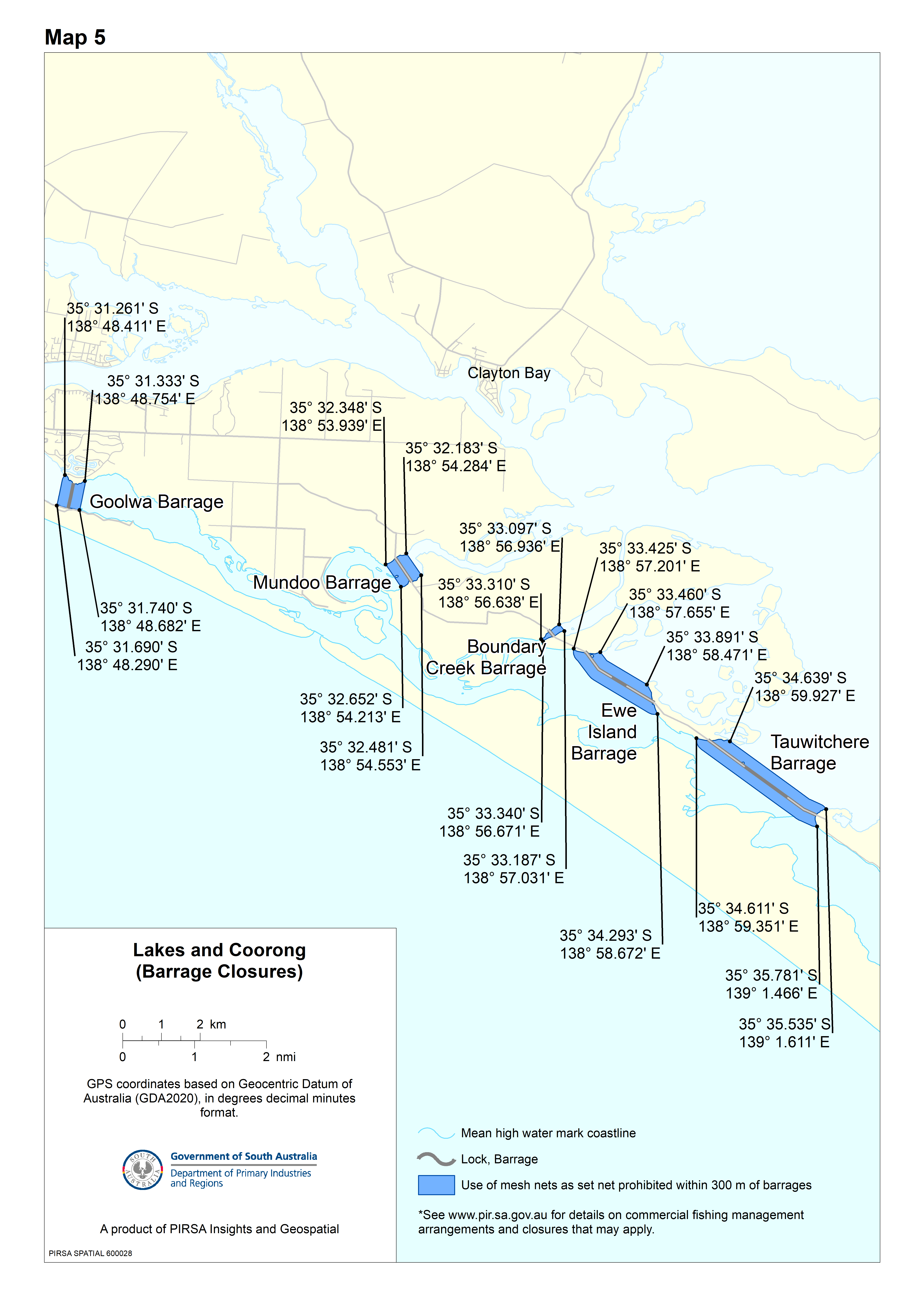
The system consists of five barrages extending from Sir Richard Peninsula in the west to Pelican Point on the northern side of the mouth of the Coorong in the east, crossing five channels between the mainland and three islands. From west to east, the five barrages are named Goolwa, Mundoo, Boundary Creek, Ewe Island and Tauwitchere.[4]
| Barrage name | Coordinates | Western shore | Eastern shore | Description | Notes |
|---|---|---|---|---|---|
| Goolwa | [ ⚑ ] 35°31′S 138°48′E / 35.517°S 138.8°E | Sir Richard Peninsula | Hindmarsh Island | Includes a lock; measures 30.5 by 6.1 m (100 by 20 ft) | [4][6] |
| Mundoo | [ ⚑ ] 35°32′S 138°54′E / 35.533°S 138.9°E | Hindmarsh Island | Mundoo Island | ||
| Boundary Creek | [ ⚑ ] 35°33′S 138°57′E / 35.55°S 138.95°E | Mundoo Island | Ewe Island | ||
| Ewe Island | [ ⚑ ] 35°33′S 138°58′E / 35.55°S 138.967°E | Ewe Island | Tauwitchere Island | ||
| Tauwitchere | [ ⚑ ] 35°35′S 139°00′E / 35.583°S 139°E | Tauwitchere Island | Pelican Point | Includes a lock; measures 13.7 by 3.8 m (45 by 12 ft) |
Engineering heritage award
The barrages are listed as a National Engineering Landmark by Engineers Australia as part of its Engineering Heritage Recognition Program.[7]
See also
- List of reservoirs and dams in South Australia
- List of tidal barrages
References
- ↑ "Getting to know the Murray: barrages". Environment SA. Government of South Australia. 2017-03-03. https://www.environment.sa.gov.au/goodliving/posts/2017/03/goolwa-barrage.
- ↑ "Topics | Water and River Murray | Basin, River Murray, Lakes, Coorong | About the River Murray". Environment SA. Government of South Australia. 2026. https://www.environment.sa.gov.au/topics/water-and-river-murray/basin-river-murray-lakes-and-the-coorong/about-the-river-murray/locks-weirs-and-storages.
- ↑ Murray Darling Basin Commission, ""Barrages - Murray Darling Basin Commission". Archived from the original on 19 March 2012. https://web.archive.org/web/20120319143536/http://www2.mdbc.gov.au/rmw/river_murray_system/barrages.html. Retrieved 2012-11-17." Retrieved 17 November 2012
- ↑ 4.0 4.1 4.2 "Lower Lakes Barrages". Murray-Darling Basin Authority. Archived from the original on 9 January 2015. https://web.archive.org/web/20150109235116/http://www.mdba.gov.au/what-we-do/managing-rivers/river-murray-system/dams-weirs/the-barrages. Retrieved 9 January 2015.
- ↑ "Coorong and Lakes Ramsar Wetland Portal". EnviroData SA. Government of South Australia. 2018-03-23. https://data.environment.sa.gov.au/Water/Data-Systems/CLLMM/SitePages/Home.aspx?ManSecID=12#Barrage%20Management.
- ↑ "Map 5 | Lakes and Coorong (Barrage Closures)" (Map). PIRSA Spatial Information Services. Government of South Australia. n.d. Retrieved 2026-04-07.
- ↑ "River Murray Barrages, 1935 to 1940-". Engineers Australia. https://portal.engineersaustralia.org.au/heritage/river-murray-barrages-1935-1940.
Template:Reservoirs in South Australia
 |  |