Earth:List of unconfirmed impact craters on Earth
This list of more than 130 possible impact craters on Earth includes theoretical impact sites that have appeared several times in the literature, or may have been endorsed by the Impact Field Studies Group (IFSG)[1] or Expert Database on Earth Impact Structures (EDEIS),[2] but not yet confirmed by the Earth Impact Database (EID).[3]
Unconfirmed impact craters
The following are officially considered "unconfirmed". Due to stringent requirements regarding evidence and peer-reviewed publication, newly discovered craters—or those where collecting evidence is difficult—are generally known for some time before becoming listed. Recent extensive surveys have been done for Australian (2005),[4] African (2014),[5] and South American (2015)[6] craters, as well as those in the Arab world (2016).[7] A book review by A. Crósta and U. Reimold disputes some of the evidence presented for several of the South American structures.[8]

Younger than one million years old
The more than 20 unconfirmed craters in the first table are younger than one million years old and at least 0.1 km in diameter. For comparison, the largest confirmed crater in the Earth Impact Database within the last 10,000 years is the 0.3 km Macha crater in Siberia.
The Cheko crater is thought by one research group to be the result of the famous Tunguska event, although sediments in the lake have been dated back more than 5000 years. There is highly speculative conjecture about the supposed Sirente impact (c. 320 ± 90 AD) causing the Roman emperor Constantine's vision at Milvian Bridge.[29]
The Burckle crater and Umm al Binni structure are proposed to be behind the floods that affected Sumerian civilization.[30][31] The Kachchh impact may have been witnessed by the Harappan civilization and mentioned as a fireball in Sanskrit texts.[15]
The age of the Bloody Creek crater is disputed, with some evidence suggesting it hit glacier ice 12000 years ago, coeval with the Younger Dryas.[18]
As the trend in the Earth Impact Database for about 26 confirmed craters younger than a million years old show that almost all are less than 2 km in diameter (except the 3 km Agoudal and 4 km Rio Cuarto), the suggestion that two large craters, Mahuika (20 km) and Burckle (30 km), formed just within the last few millennia has been met with skepticism.[32][33][34]
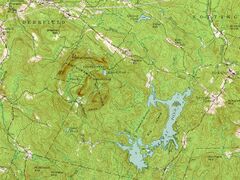
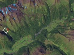
However, the source of the young (less than a million years old) and enormous Australasian strewnfield (c. 790 ka) is suggested to be a crater about 100 km across somewhere in Indochina,[35][36] with Hartung and Koeberl (1994) proposing the elongated 100 km × 35 km Tonlé Sap lake in Cambodia (visible in the map at the side) as a suspect structure.[37]


Older than one million years old
The more than 110 suspected craters in the table below are either older than 1 Ma, or have an unknown age.
The Decorah crater has been conjectured as being part of the Ordovician meteor event.[138]
Several twin impacts have been proposed such as the Rubielos de la Cérida and Azuara (30–40 Ma),[139] Cerro Jarau and Piratininga (c. 117 Ma),[9] and Warburton East and West (300–360 Ma).[131] However, adjacent craters may not necessarily have formed at the same time such as case of the confirmed Clearwater East and West lakes.
Some confirmed impacts like Sudbury or Chicxulub are also sources of magnetic anomalies[140] and/or gravity anomalies. The magnetic anomalies Bangui and Jackpine Creek,[81] the gravity anomalies Wilkes Land crater and Falkland Islands,[64] and others have been considered as being of impact origin. Bangui apparently has been discredited,[43][141] but appears again in a 2014 table of unconfirmed structures in Africa by Reimold and Koeberl.[5]
Several anomalies in Williston Basin were identified by Swatzky in the 1970s as astroblemes including Viewfield, Red Wing Creek, Eagle Butte, Dumas, and Hartney, of which only the last two are unconfirmed.[60]
The Eltanin impact has been confirmed (via an iridium anomaly and meteoritic material from ocean cores) but, as it fell into the Pacific Ocean, apparently no crater was formed. The age of Silverpit and the confirmed Boltysh crater (65.17 ± 0.64 Ma), as well as their latitude, has led to the speculative hypothesis that there may have been several impacts during the KT boundary.[142][143] Of the five oceans in descending order by area, namely the Pacific, Atlantic, Indian, Antarctic, and Arctic, only the smallest (the Arctic) does not yet have a proposed unconfirmed impact crater.
Craters larger than 100 km in the Phanerozoic (after 541 Ma) are notable for their size as well as for the possible coeval events associated with them especially the major extinction events.
For example, the Ishim impact structure[79] is conjectured to be bounded by the late Ordivician-early Silurian (c. 445 ± 5 Ma),[80] the two Warburton basins has been linked to the Late Devonian extinction (c. 360 Ma),[132] both Bedout and the Wilkes Land crater have been associated with the severe Permian–Triassic extinction event (c. 252 Ma),[144][145] Manicouagan (c. 215 Ma) was once thought to be connected to the Triassic–Jurassic extinction event (c. 201 Ma)[146] but more recent dating has made it unlikely, while the consensus is the Chicxulub impact caused the one for Cretaceous–Paleogene (c. 66 Ma).
However, other extinction theories employ coeval periods of massive volcanism such as the Siberian Traps.
Undiscovered but inferred

There is geological evidence for impact events having taken place on Earth on certain specific occasions, which should have formed craters, but for which no impact craters have been found. In some cases this is because of erosion and Earth's crust having been recycled through plate tectonics, in others likely because exploration of the Earth's surface is incomplete. Typically the ages are already known and the diameters can be estimated.
| Parent Crater of | Expected Crater Diameter (km) | Age |
|---|---|---|
| Dakhleh glass[147][148] | 0.4 km | 150 ka |
| Argentinian tektites[149] | 5 km | 480 ka |
| Australasian tektites[36] | 32–114 km | 780 ka |
| Central American tektites[150][151] | 14 km | 820 ka |
| Skye ejecta deposits[152] | Unknown | 60 Ma |
| Stac Fada Member | 40 km | 1.2 Ga |
| Barberton Greenstone Belt microtektites[153] | 500 km | 3.2 Ga |
| Marble Bar impact spherules[154] | "hundreds of kilometers" | 3.4 Ga |
Formerly unconfirmed

.png)
As of Jan 2017, the Earth Impact Database has risen to 190 confirmed impact craters (from 178 by the end of 2010). The following had their status upgraded from unconfirmed to confirmed in the last few years.
Malingen crater is thought to be a double impact with Lockne crater.[157] The pair, plus Hummeln and several other Ordovician craters in a small region in Europe, have been speculated to be connected to the Ordovician meteor event.[158]
Mistaken identity
Some geological processes can result in circular or near-circular features that may be mistaken for impact craters. Some examples are calderas, maars, sinkholes, glacial cirques, igneous intrusions, ring dikes, salt domes, geologic domes, ventifacts, tuff rings, forest rings, and others. Conversely, an impact crater may originally be thought as one of these geological features, like Meteor Crater (as a maar) or Upheaval Dome (as a salt dome).
The presence of shock metamorphism and shatter cones are important criteria in favor of an impact interpretation, though massive landslides (such as the Köfels landslide of 7800 BC which was once thought to be impact-related) may produce shock-like fused rocks called "frictionite".[159]
-
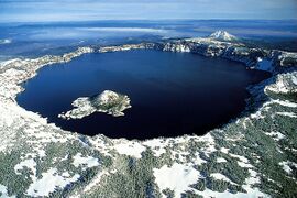 Crater Lake, Oregon (a caldera)
 -
 Three maars in Germany
 -
 Great Blue Hole, Belize (a sinkhole)
 -
 Verdi Lake (a glacial cirque)
 -
![Kondyor Massif or Konder (an igneous intrusion)[160]](/wiki/images/thumb/d/da/Kondyor-view.jpg/196px-Kondyor-view.jpg)
-
 Ring dike on Pawtuckaway State Park
 -
 Salt domes on Melville Island
 -
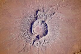
![Richat structure (and the similar Semsiyat)[161] as a geologic dome[162]](/wiki/images/thumb/6/6b/ASTER_Richat.jpg/191px-ASTER_Richat.jpg)
-
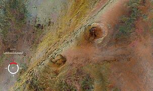 The Arkenu structures are now considered as a ventifact
 -
 Brukkaros Mountain as a tuff ring
 -
 A forest ring from Ontario.
 -
 The Köfels landslide


![Kondyor Massif or Konder (an igneous intrusion)[160]](/wiki/File:Kondyor-view.jpg)


![Richat structure (and the similar Semsiyat)[161] as a geologic dome[162]](/wiki/File:ASTER_Richat.jpg)


See also
- Earth Impact Database
- Gliese 710 – example of gravitational perturbations (in mega-year scale) of the Solar System
- Impact Field Studies Group
- Impact craters
- Impact events
- List of impact craters on Earth
- List of meteor air bursts
- Tollmann's hypothetical bolide
- Traces of Catastrophe book from Lunar and Planetary Institute – comprehensive reference on impact crater science
References
- ↑ Impact Field Studies Group
- ↑ Expert Database on Earth Impact Structures
- ↑ Earth Impact Database
- ↑ P. W. Haines (2005). Impact cratering and distal ejecta: the Australian record, Australian Journal of Earth Sciences, v. 52, p. 481–507.
- ↑ 5.0 5.1 5.2 5.3 5.4 W. Reimold & C. Koeberl (2014). Impact structures in Africa: A review, Journal of African Earth Sciences, Volume 93, May 2014, Pages 57–175.
- ↑ R. Acevedo, M. C. Rocca, J. Ponce, S. Stinco (2015). Impact Craters in South America, Springer, Apr 25, 2015.
- ↑ M. C. Chabou (2016). An updated inventory of meteorite impact structures in the Arab world, 1st ArabGU International Conference, Feb 2016, Algeria
- ↑ A. Crósta and U. Reimold (2016). A Book Review: "Impact Craters in South America, by R. D. Acevedo et al."
- ↑ 9.0 9.1 9.2 9.3 9.4 A. Crósta, R. Romano (2004). Brazilian Impact Craters: A Review, 35th Lunar and Planetary Science Conference (2004)
- ↑ Meteorite crater site of Ak-Bura
- ↑ Bacharev, A (1952), The Murgab meteorite crater. Astron. Tsirk., No 122, p.8-10
- ↑ 12.00 12.01 12.02 12.03 12.04 12.05 12.06 12.07 12.08 12.09 12.10 12.11 12.12 12.13 12.14 Expert Database on Earth Impact Structures (EDEIS), Accessed May 2016
- ↑ J. B. Garvin and J. J. Frawley (2008). Geometric Properties Of The Merewether Structure, Newfoundland, Canada.Lunar and Planetary Science XXXIX (2008)
- ↑ V. Feldman, A. Kiselev (2008). Shock-melted impactites at the Svetloyar meteorite crater Volga area, Russia, Lunar and Planetary Science XXXIX
- ↑ 15.0 15.1 R. V. Karanth, P. Thakker, and M. Gadhavi 2006. A preliminary report on the possible impact crater of Kachchh, Current Science, vol. 91, no. 7, October 2006
- ↑ 16.0 16.1 Dietrich, V. J; Lagios, E; Reusser, E; Sakkas, V; Gartzos, E; Kyriakopoulos, K (2013). "The enigmatic Zerelia twin-lakes (Thessaly, Central Greece): two potential meteorite impact Craters". Solid Earth Discussions 5 (2): 1511–1573. doi:10.5194/sed-5-1511-2013. Bibcode: 2013SolED...5.1511D.
- ↑ L. L. Kashkarov, D. D. Badjukov, A. I. Ivliev, G. V. Kalinina, and M. A. Nazarov, Vernadsky (2005). The Smerdyacheye Lake: New Evidence For Impact Origin And Formation Age, Lunar and Planetary Science XXXVI (2005)
- ↑ 18.0 18.1 Stevens, G, I Spooner, J Morrow, P Pufahl, R Raeside, RAF Grieve, CR Stanley, SM Barr, and D McMullin (2008) Physical evidence of a late-glacial (Younger Dryas?) impact event in southwestern Nova Scotia. Atlantic Geology. 44:42.
- ↑ Heinrich, P.V. (2003) Possible Meteorite Impact Crater in St. Helena Parish, Louisiana. Search and Discovery Article. no. 50006. American Association of Petroleum Geologist, Tulsa, Oklahoma. Retrieved March 27, 2011.
- ↑ 20.0 20.1 20.2 20.3 A. Rossi (2002). Seven Possible New Impact Structures In Western Africa Detected On Aster Imagery, Lunar and Planetary Science XXXIII
- ↑ Sakamoto, Masao; Gucsik, Arnold; Nishido, Hirotsugu; Ninagawa, Kiyotaka; Okumura, Tasuku; Toyoda, Shin (2010), "Micro Raman spectroscopy of anomalous planar microstructures in quartz from Mt. Oikeyama: Discovery of a probable impact crater in Japan", Meteoritics and Planetary Science, doi:10.1111/j.1945-5100.2009.01003.x, http://onlinelibrary.wiley.com/doi/10.1111/j.1945-5100.2009.01003.x/epdf
- ↑ Cannon, P.J. (1977) Meteorite impact crater discovered in central alaska with landsat imagery, Science, 1977 Jun 17;196(4296):1322-4.
- ↑ Ned Rozell (2008) The mystery of mammoth tusks with iron fillings
- ↑ Jonathan T. Hagstrum, Richard B. Firestone, Allen West, Zsolt Stefanka and Zsolt Revay(2010). Micrometeorite Impacts in Beringian Mammoth Tusks and a Bison Skull
- ↑ 25.0 25.1 Harris, R. S.; Schultz, P. H.; Zárate, M. A. (2007) La Dulce Crater: Evidence For A 2.8 Km Impact Structure In The Eastern Pampas Of Argentina, 38th Lunar and Planetary Science Conference
- ↑ R. D. Acevedo, J. Rabassa, M. J. Orgeira, et al. (2010) Bajada Del Diablo Impact Crater Strewn-Field, Patagonia, Argentina: The Largest Crater Field In The World? 73rd Annual Meteoritical Society Meeting
- ↑ Acevedo, R. D.; Rabassa, J.; Ponce, J. F, et al. (2012) The Bajada del Diablo astrobleme-strewn field, central Patagonia Argentina: Extending the exploration to surrounding areas Geomorphology, Volume 169, p. 151-164.
- ↑ H. Povenmire, R.S. Harris, and J.H. Cornec (2011), The New Central American Tektite Strewn Field, 42nd Lunar and Planetary Science Conference (2011)
- ↑ Whitehouse, David (2003-06-23). "Space impact 'saved Christianity'". BBC News. British Broadcasting Corporation. http://news.bbc.co.uk/2/hi/science/nature/3013146.stm. Retrieved 2009-09-10.
- ↑ Sandra Blakeslee (2006). Ancient Crash, Epic Wave
- ↑ Master, S. (2002) Umm al Binni lake, a possible Holocene impact structure in the marshes of southern Iraq. In: Leroy, S. and Stewart, I.S. (Eds.), Environmental Catastrophes and Recovery in the Holocene, Abstracts Volume, Brunel University, UK, 29 August – 2 September 2002, pp. 56–57
- ↑ Goff, James (2010). "Analysis of the Mahuika comet impact tsunami hypothesis". Marine Geology 271 (3/4): 292–296. doi:10.1016/j.margeo.2010.02.020. Bibcode: 2010MGeol.271..292G.
- ↑ Bourgeois, J., and R. Weiss (2009) 'Chevrons' are not mega-tsunami deposits; a sedimentologic assessment. Geology. 37(5):403–406.
- ↑ Pinter, N., and S.E. Ishman, S.E. (2008). Impacts, mega-tsunami, and other extraordinary claims. GSA Today. 18(1):37.
- ↑ Povenmire H., Liu W. and Xianlin I. (1999) "Australasian tektites found in Guangxi Province, China", 30th Annual Lunar and Planetary Science Conference, Houston, March 1999.
- ↑ 36.0 36.1 Glass B.P. and Pizzuto J.E. (1994) "Geographic variation in Australasian microtektite concentrations: Implications concerning the location and size of the source crater," J of Geophysical Research, vol 99, no E9, 19075-19081, Sept 1994.
- ↑ Hartung J. and Koberl C. (1994) "In search of the Australasian tektite source crater: the Tonle sap hypothesis", Meteoritics.
- ↑ 38.0 38.1 Garvin, J. B. & Blodget, H. W. (1986). Suspected Impact Crater Near Al Madafi, Saudi Arabia, Meteoritics, Vol. 21, p.366
- ↑ 39.0 39.1 Roger Weller. Al Madafi crater
- ↑ Henry Brean (2015). New study ranks Nevada crater among world's largest, Las Vegas Review Journal
- ↑ Roger Weller Anefis crater
- ↑ Ocampo, A. & Pope, K. (1996). Shuttle Imaging Radar (SIR-C) Images Reveal Multiple Impact Craters at Aorounga, Northern Chad, Lunar and Planetary Science, volume 27, page 977.
- ↑ 43.0 43.1 43.2 S. Master & W. Reimold (2000). The impact cratering record of Africa: An updated inventory of proven, probable, possible, and discredited impact structures on the African continent, Catastrophic Events Conference 2000.
- ↑ Zeilik, B. (1987). The Arganaty cosmogenic crater in southern Kazakhstan and the ring structures associated with it. Akademiia Nauk SSSR, Doklady, vol. 297, no. 4, 1987, p. 925-928.
- ↑ M. Barash (2012). Mass Extinction of Ocean Organisms at the Paleozoic–Mesozoic Boundary: Effects and Causes. Oceanology, 2012, Vol. 52, No. 2, pp. 238–248.
- ↑ David Rajmon (2010). Impact Field Studies Group
- ↑ Marc Fokker (2008). Astroforum Netherlands
- ↑ M. C. Rocca (2005). BAJO HONDO, CHUBUT, PATAGONIA, ARGENTINA: A NEW METEORITE IMPACT CRATER IN BASALT?, 68th Annual Meteoritical Society Meeting
- ↑ Girdler, R.; Taylor, P.; Frawley, J. (1992). A possible impact origin for the Bangui magnetic anomaly (Central Africa). Tectonophysics, Volume 212, Issue 1, p. 45-58
- ↑ S. Master, G.R.J. Cooper and K. Klajnik (2013). The Bateke Plateau Structure – A New Possible 7 Km Diameter Quaternary Meteorite Impact Structure In Gabon: A Remote Sensing Study, 13th SAGA Biennial Conference & Exhibition
- ↑ R. A. Graham (2005) Reinvestigation of the Bee Bluff Structure South of Uvalde, Texas, 'The Uvalde Crater'. Lunar and Planetary Science XXXVI (2005)
- ↑ H. Henkel, A. Bäckström, B. Bergman, O. Stephansson, and M. Lindström (2005). Geothermal Energy from Impact Craters? The Björkö Study, Proceedings World Geothermal Congress 2005
- ↑ M. Papagiannis (1989). Photographs from geostationary satellites indicate the possible existence of a huge 300 KM impact crater in the Bohemian region of Czechoslovakia, Meteoritics, Vol. 24, p.313.
- ↑ P. Rajlich (1992). Bohemian Circular Structure, Czechoslovakia: Search for the Impact Evidence, International Conference on Large Meteorite Impacts and Planetary Evolution. Held 1992, in Sudbury, Canada
- ↑ Paul Rincon (2006). Space impact clue in Antarctica, BBC News
- ↑ 56.0 56.1 L. P. Hrjanina (Khryanina), 2006.. "Once again about Kainozoic meteorite structures in the Ross Sea, Antarctica". http://www.lpi.usra.edu/meetings/LPSC98/pdf/1152.pdf.
- ↑ "Evidence for a Possible Late Pliocene Impact in the Ross Sea, Antarctica". http://www.ldeo.columbia.edu/~dallas/abbott_publications/Gerard-Little_et_al_2006_Abstract_Ross.html.
- ↑ Mark R. Legg, Craig Nicholson, Chris Goldfinger, Randall Milstein, and Marc Kamerling (2004). Large enigmatic crater structures offshore southern California, Geophys. J. Int. (2004) 159, 803–815
- ↑ 59.0 59.1 59.2 59.3 A. Crósta, M. Vasconcelos (2013). Update On The Current Knowledge Of The Brazilian Impact Craters, 44th Lunar and Planetary Science Conference (2013)
- ↑ 60.0 60.1 60.2 Gubins, A. & Strangway, D. (1978). Magnetic Fields Associated with a Probable Late Cretaceous Astrobleme at Dumas, Saskatchewan, LUNAR AND PLANETARY SCIENCE IX, PP. 433–435
- ↑ Wu Siben (1989).. Geologic feature of the Duolun impact crater. Bibcode: 1989LPI....20.1219W.
- ↑ El-Baz, F. (1981). Science, 213, 439–440.
- ↑ M. Schmieder and E. Buchner (2010). The Faya Basin (Chad) revisited – structural insights from central peak morphology and potential Martian analogs, Nördlingen Ries Crater Workshop (2010).
- ↑ 64.0 64.1 M. Rocca and J. Presser (2015) A possible new very large impact structure in Malvinas Islands, Historia Natural, Tercera Series, Volumen 5(2), 2015.
- ↑ Acevedo, R. D.; Rocca, M. C. L.; Ponce, J.; Stinco, S. G. (2015). Impact Craters in South America. Springer. p. 23. ISBN 978-3-319-13093-4. https://books.google.com/books?id=W226CAAAQBAJ.
- ↑ Maximiliano C.L. Rocca et al. (2017).. "Geophysical evidence for a large impact structure on the Falkland (Malvinas) Plateau". doi:10.1111/ter.12269. http://onlinelibrary.wiley.com/wol1/doi/10.1111/ter.12269/abstract.
- ↑ Hannah Osborne (May 5, 2017). "Crater Potentially Linked to the Biggest Mass Extinction Event in Earth’s History is Discovered". Newsweek Tech & Science. http://www.newsweek.com/asteroid-impact-crater-mass-extinction-great-dying-595229.
- ↑ Amos, J (2009) 'Fried Egg' may be impact crater BBC News.
- ↑ Roger Weller. Garet El Lefet crater
- ↑ 70.0 70.1 J. Classen (1977). Catalogue of 230 certain, probable, possible, and doubtful impact structures, Meteoritics, vol. 12, Mar. 31, 1977, p. 61-78.
- ↑ R. D. Acevedo, M. Rocca, J. Rabassa and J. F. Ponce (2011) Meteorite Impact Craters In South America: A Brief Review. 74th Annual Meteoritical Society Meeting (2011)
- ↑ R. Iaskty and A. Glikson (2005). "Gnargoo: a possible 75 km-diameter post-Early Permian – pre-Cretaceous buried impact structure, Carnarvon Basin, Western Australia", Australian Journal of Earth Sciences, Vol 52, 2005
- ↑ C. Anderson (1980). A Seismic Reflection Study of a Probable Astrobleme near Hartney, Manitoba
- ↑ J. Glidewell (2009). SEISMIC DATA THROUGH THE HICO STRUCTURE: A POSSIBLE IMPACT FEATURE IN NORTHCENTRAL TEXAS, 40th Lunar and Planetary Science Conference
- ↑ M. Mazur and R. Stewart (1998). Interpreting the Hotchkiss structure: A possible meteorite impact feature in northwestern Alberta, Consortium for Research in Elastic Wave Exploration Seismology (CREWES).
- ↑ B. Deane, P. Lee, K. Milam, J. Evenick, and R.Zawislak (2004). THE HOWELL STRUCTURE, LINCOLN COUNTY, TENNESSEE: A REVIEW OF PAST AND CURRENT RESEARCH, Lunar and Planetary Science XXXV
- ↑ Milam, K. A., Henderson, T., Deane, B. (2014). An Assessment Of Shock Metamorphism In Breccias From The Howell Structure, Lincoln County, Tennessee, USA, Abstracts of the 2014 GSA Annual Meeting, Geological Society of America
- ↑ E. Ghoneim (2009). Ibn-Batutah: A possible simple impact structure in southeastern Libya, a remote sensing study, Geomorphology, Volume 103, Issue 3, p. 341-350.
- ↑ 79.0 79.1 Frank Dachille (1976).. Frequency of the formation of large terrestrial impact craters. Bibcode: 1976Metic..11..270D.
- ↑ 80.0 80.1 Zeylik B. S.; Seytmuratova E. Yu, 1974: A meteorite-impact structure in central Kazakhstan and its magmatic-ore controlling role. Doklady Akademii Nauk SSSR: 1, Pages 167–170
- ↑ 81.0 81.1 S. Goussev, R. Charters, J. Peirce and W. Glenn (2002). Jackpine Creek Magnetic Anomaly: A Case of the HRAM Prospect Scale Interpretation. CSEG: The Canadian Society of Exploration Geophysicists
- ↑ Martin Schmieder, Elmar Buchner, & Daniel Paul Le Heron (2009). The Jebel Hadid structure (Al Kufrah Basin, SE Libya)—A possible impact structure and potential hydrocarbon trap?, Marine and Petroleum Geology, Volume 26, Issue 3, March 2009, Pages 310–318
- ↑ Sharad Master, Brad Pitts and Marek Wendorff (2009). Jwaneng South Structure, Botswana: a New 1.3 km Diameter Buried Cenozoic Impact Crater Discovered by Airship-mounted Gravity Gradometer, 11th SAGA Biennial Technical Meeting and Exhibition
- ↑ M.S. Huber, D.T. King, Jr., L.W. Petruny, and C. Koeberl (2013). REVISITING KILMICHAEL (MISSISSIPPI), A POSSIBLE IMPACT STRUCTURE, 44th Lunar and Planetary Science Conference
- ↑ T. Marjanac, A. Tomša, Lj. Marjanac, M. Calogovic & S. Fazinic (2015). Krk impact structure ejecta breccia and melt rocks on the islands of Krk and Rab, Croatian Adriatic: A clue on the impact target lithology, Bridging the Gap III (2015)
- ↑ S. A. Vishnevsky (2007). The Kurai Basin, Altai mountains (Russia): First evidences of impact origin, Lunar and Planetary Science XXXVIII (2007)
- ↑ Dietz, R. S. & McHone, J. (1974). Impact structures from ERTS imagery, Meteoritics, Vol. 9, p.329
- ↑ Roger Weller. Labynkyr ring
- ↑ James B. Garvin (1986). POSSIBLE IMPACT STRUCTURES IN CENTRAL AFRICA
- ↑ Roger Weller. Tai Hu crater
- ↑ Wang, K.; Geldsetzer, H. H. J. (1992). "A late Devonian impact event and its association with a possible extinction event on Eastern Gondwana". Lunar and Planetary Inst., International Conference on Large Meteorite Impacts and Planetary Evolution: 77. Bibcode: 1992lmip.conf...77W.
- ↑ B. J. Hamill (2003). The Loch Leven Crater: Anatomy Of A Low-Angle Oblique Impact Structure, Large Meteorite Impacts (2003)
- ↑ P. Tonkin (1998). Lorne Basin, New South Wales: Evidence for a possible impact origin?, Australian Journal of Earth Sciences, Volume 45, Issue 5, 1998
- ↑ D. Nisca, H. Thunehed, L.J. Pesonen, S-Å. Elming (1997). The Lycksele structure, a huge ring formation in northern Sweden: result of an impact?, Large Meteorite Impacts and Planetary Evolution
- ↑ L.J. Pesonen (1996). The Impact Cratering Record of Fennoscandia, Earth, Moon and Planets, Volume 72, Issue 1–3, pp. 377–393
- ↑ Roger Weller. Madagascar structure
- ↑ Tamas Bodoky et al. (2007). Is the Magyarmecske telluric conductivity anomaly a buried impact structure?
- ↑ Garde, Adam A.; McDonald, Iain; Dyck, Brendan; Keulen, Nynke (2012). "Searching for giant, ancient impact structures on Earth: The Mesoarchaean Maniitsoq structure, West Greenland". Earth and Planetary Science Letters 337–338: 197. doi:10.1016/j.epsl.2012.04.026. Bibcode: 2012E&PSL.337..197G.
- ↑ Scherst, Anders; Garde, Adam A. (30 July 2013). "Complete hydrothermal re-equilibration of zircon in the Maniitsoq structure, West Greenland: A 3001 Ma minimum age of impact?" (PDF). Meteoritics & Planetary Science 48 (8): 1472–1498. doi:10.1111/maps.12169. Bibcode: 2013M&PS...48.1472S. http://onlinelibrary.wiley.com/doi/10.1111/maps.12169/pdf. Retrieved 21 August 2016.
- ↑ Roger Weller. Mejaouda crater
- ↑ A.C. Ocampo, A.C. Garrido, J. Rabassa, M.C. Rocca, J.C. Echaurren, and E. Mazzoni (2005). A Possible Impact Crater In Basalt At Meseta De La Barda Negra, Neuquen, Argentina, 68th Annual Meteoritical Society Meeting
- ↑ G. Burba (1991). Middle-Urals Ring structure, USSR: Definition, description, possible planetary analogues, Lunar and Planetary Science conference XXII.
- ↑ G. Burba (2003). The geologic evolution of the Ural Mountains: A supposed exposure to a giant impact. Microsymposium 38, MS011, 2003
- ↑ A. Glikson, D. Jablonski, & S. Westlake (2010). Origin of the Mt Ashmore structural dome, west Bonaparte Basin, Timor Sea. Australian Journal of Earth Sciences, Volume 57, Issue 4
- ↑ Examining a new asteroid crater found in the Timor Sea. ScienceWise 2010, Australian National Uni
- ↑ Elmar Buchner, Martin Schmieder (2007). Mousso structure: a deeply eroded, medium-sized complex impact crater in northern Chad?, Journal of African Earth Sciences 49, 71–78
- ↑ J. B. Plescia (1999). Mulkarra Impact Structure, South Australia: A Complex Impact Structure, Lunar and Planetary Science XXX
- ↑ J.M. Comstock and J.R. Morrow (2000). PEERLESS STRUCTURE SOUTHWESTERN DANIELS COUNTY, MONTANA: A PROBABLE MIDORDOVICIAN IMPACT EVENT, Lunar and Planetary Science XXXI
- ↑ B. Levin, E. Gretskaya, G. Nemchenko (2006). A new astrobleme in the Pacific Ocean, Doklady Earth Sciences, 2006, Vol. 411, No. 8, pp.1336–1338.
- ↑ W. D. MacDonald, A. P. Crosta, J. Francolin (2006) Structural Dome At São Miguel do Tapuio, Piaui, Brazil, 69th Annual Meteoritical Society Meeting (2006)
- ↑ Dietz, R. & McHone, J. (1991). Astroblemes Recently Confirmed with Shatter Cones, Abstracts for the 54th Annual Meeting of the Meteoritical Society. Held July 21–26, 1991.
- ↑ Wu Siben (1988). The Shanghewan Impact Crater, China, Abstracts of the Lunar and Planetary Science Conference, volume 19, page 1296, (1988)
- ↑ S. A. Vishnevsky (2007). Shiyli Dome, Kazakhstan: Origin Of Central Uplift By Elastic Response, Workshop on Impact Cratering II
- ↑ "A 20-km-diameter multi-ringed impact structure in the North Sea". Nature 418 (6897): 520–3. 2002. doi:10.1038/nature00914. PMID 12152076. Bibcode: 2002Natur.418..520S.
- ↑ A. Sparavigna (2010) Crater-Like Landform in Bayuda Desert (A Processing of Satellite Images)
- ↑ A. Sparavigna (2010) Craters and ring complexes of the North-East Sudanese country
- ↑ G. Di Achille (2005). A New Candidate Impact Site In Northeastern Sudan Detected From Remote Sensing, Lunar and Planetary Science XXXVI
- ↑ Y. Miura (2007) Analyses Of Surface And Underground Data Of Takamatsu Crater In Japan. Lunar and Planetary Science XXXVIII (2007)
- ↑ Philippe Paillou et al. (2006).An extended field of crater-shaped structures in the Gilf Kebir region, Egypt: Observations and hypotheses about their origin, Journal of African Earth Sciences
- ↑ Roger Weller. Tarek crater
- ↑ 121.0 121.1 B. W. Levin, S. A. Vishnevsky, and N. A. Palchik (2010). Underwater depressions on the bottom of the Tatarsky Strait, the Sea of Japan (western coast of the Sakhalin Island, Russia): possible marine impact craters, 41st Lunar and Planetary Science Conference (2010)
- ↑ J. de Menezes, C. de Souza, F. Fortes, and C. Filho (1999). Geophysical Evidence Of A Possible Impact Structure At The K-T Boundary Of The Solimões Basin, Brazil, 6th International Congress of the Brazilian Geophysical Society
- ↑ K. Bron (2015) The Tookoonooka-Talundilly tsunami sequence: constraining marine impact stratigraphy, Australian School of Petroleum, The University of Adelaide
- ↑ Roger Weller. Temimichat crater
- ↑ G. Komatsu et al. (2015)The Tsenkher structure, Gobi-Altai, Mongolia: A probable impact crater with well-preserved rampart ejecta. 46th Lunar and Planetary Science Conference (2015)
- ↑ "Potential asteroid impact identified in western Queensland". Geoscience Australia. http://www.ga.gov.au/news-events/news/latest-news/potential-asteroid-impact-identified-in-western-queensland. Retrieved 26 June 2016.
- ↑ C. Koeberl (1990). The Kara/Ust-Kara twin impact structure. Geological Society of America, special paper.
- ↑ S. Wade, M. Barbieri, J. Lichtenegger (2001) The Velingara Circular Structure Esa Bulletin June 2001
- ↑ Harris, J. B., Jones, D. R., & Street, R. L. (1991). A shallow seismic refraction study of the Versailles cryptoexplosion structure, central Kentucky, Meteoritics, vol. 26, March 1991, p. 47-53
- ↑ UQ Researcher Discovers Giant Asteroid Impact, University News and Information Service (2010)
- ↑ 131.0 131.1 131.2 World's largest asteroid impact zone found in Australia: Meteorite broke in two, leaving two craters each 200 km across. Mar 24, 2015
- ↑ 132.0 132.1 132.2 Stephen Luntz (2013). Huge Asteroid Impact Identified. Australasian Science
- ↑ G. Monegato; M. Massironi; E. Martellato (2010). "The Ring Structure of Wembo-Nyama (Eastern Kasai, R.D. Congo): A Possible Impact Crater in Central Africa". Lunar and Planetary Science (Lunar and Planetary Institute) XLI. http://www.lpi.usra.edu/meetings/lpsc2010/pdf/1601.pdf.
- ↑ "Ring may be giant 'impact crater'". BBC News. 2010-03-10. http://news.bbc.co.uk/2/hi/science/nature/8526093.stm. Retrieved 2010-05-08.
- ↑ E. F. Albin and R. S. Harris (2016). WOODBURY ASTROBLEME: FURTHER EVIDENCE FOR A LATE PROTEROZOIC IMPACT STRUCTURE IN WEST-CENTRAL GEORGIA, USA, 47th Lunar and Planetary Science Conference
- ↑ Dentith, M., Bevan, A., Backhouse, J., Featherstone, W., and Koeberl, C. (1999). Yallalie: a Buried Structure of Possible Impact Origin in the Perth Basin, Western Australia. Geological Magazine 136 (6): pp. 619–632.
- ↑ Grant, B. The Yallalie Impact Structure.
- ↑ Vastag, Brian (18 February 2013). "Crater found in Iowa points to asteroid break-up 470 million years ago". Washington Post. https://www.washingtonpost.com/national/health-science/crater-found-in-iowa-points-to-asteroid-break-up-470-million-years-ago/2013/02/18/545131f8-76d5-11e2-aa12-e6cf1d31106b_story.html?wprss=rss_national. Retrieved 19 February 2013.
- ↑ Ernstson, K., Claudin, F., Schüssler, U. & Hradil, K. (2002): The mid-Tertiary Azuara and Rubielos de la Cérida paired impact structures (Spain) – Treb. Mus. Geol. Barcelona, 11, 5 – 65.
- ↑ Magnetic anomaly map, Sudbury, Ontario and Quebec. Natural Resources Canada
- ↑ L. Antoine, W. Reimold, and A. Tessema (1999) The Bangui Magnetic Anomaly Revisited, 62nd Annual Meteoritical Society Meeting
- ↑ Howard Falcon-Lang (2010). Double space strike 'caused dinosaur extinction', BBC News
- ↑ Jolley D., Gilmour I., Gurov E., Kelley S., Watson J. (2010) Two large meteorite impacts at the Cretaceous-Paleogene boundary Geology September 2010, v. 38, pp. 835–838, doi:10.1130/G31034.1
- ↑ Becker L., Shukolyukov A., Macassic C., Lugmair G. & Poreda R. 2006. Extraterrestrial Chromium at the Graphite Peak P/Tr boundary and in the Bedout Impact Melt Breccia. Lunar and Planetary Science XXXVII (2006), abstract # 2321.PDF
- ↑ Gorder, Pam Frost (June 1, 2006). "Big Bang in Antarctica – Killer Crater Found Under Ice". Ohio State University Research News. Archived from the original on March 6, 2016. https://web.archive.org/web/20160306140004/http://researchnews.osu.edu/archive/erthboom.htm.
- ↑ Hodych, J.P.; G.R.Dunning (1992). "Did the Manicouagan impact trigger end-of-Triassic mass extinction?". Geology 20: 51.54. doi:10.1130/0091-7613(1992)020<0051:DTMITE>2.3.CO;2. Bibcode: 1992Geo....20...51H.
- ↑ A. Haldeman et al. (2005). Mapping Impact Modified Sediments: Subtle Remote-Sensing Signatures of the Dakhleh Oasis Catastrophic Event, Western Desert, Egypt, Bulletin of the American Astronomical Society, Vol. 37, p.648
- ↑ G. Osinski, A. Haldemann, et al. (2007). Impact Glass At The Dakhleh Oasis, Egypt: Evidence For A Cratering Event Or Large Aerial Burst?, Lunar and Planetary Science XXXVIII
- ↑ P. Bland et al. (2002). A possible tektite strewn field in the Argentinian Pampa, Science, Volume 296, Issue 5570, pp. 1109–1112
- ↑ H. Povenmire, R. S. Harris, and J. H. Cornec (2011). The New Central American Tektite and Strewn Field. 42nd Lunar and Planetary Science Conference, Houston, Texas. abstract no. 1224.
- ↑ H. Povenmire, B. Burrer, J. H. Cornec, and R. S. Harris (2012). The New Central American Tektite Strewn Field Update. 43rd Lunar and Planetary Science Conference, Houston, Texas. abstract no. 1260.
- ↑ Drake, Simon M.; Beard, Andrew D.; Jones, Adrian P.; Brown, David J.; Fortes, A. Dominic; Millar, Ian L.; Carter, Andrew; Baca, Jergus et al. (2017). "Discovery of a meteoritic ejecta layer containing unmelted impactor fragments at the base of Paleocene lavas, Isle of Skye, Scotland". Geology 46 (2): 171. doi:10.1130/g39452.1. http://pubs.geoscienceworld.org/geology/gsa/geology/article/525169/Discovery-of-a-meteoritic-ejecta-layer-containing.
- ↑ “Scientists reconstruct ancient impact that dwarfs dinosaur-extinction blast”, American Geophysical Union, April 9, 2014
- ↑ McKirdy, Euan. "This apocalyptic asteroid's impact was bigger than one that killed dinosaurs". CNN. http://www.cnn.com/2016/05/18/health/australia-asteroid-discovery-dinosaur-trnd/index.html. Retrieved 19 May 2016.
- ↑ CHENNAOUI AOUDJEHANE, H., EL KERNI, H., REIMOLD, W., BARATOUX, D., KOEBERL, C., BOULEY, S., and AOUDJEHANE, M. (2016). "The Agoudal (High Atlas Mountains, Morocco) shatter cone conundrum: A recent meteorite fall onto the remnant of an impact site". Meteoritics & Planetary Science, pp.1–22, 2016.
- ↑ Kenkmann, T., Afifi, A. M., Stewart, S. A., Poelchau, M. H., Cook, D. J. and Neville, A. S. (2015), Saqqar: A 34 km diameter impact structure in Saudi Arabia. Meteoritics & Planetary Science, 50: 1925–1940.
- ↑ Raul Rincon (2014). BBC News: "Ancient Earth hammered by double space impact", 18 March 2014
- ↑ L. Ferrière, C. Alwmark, S. Holm-Alwmark, J. Ormö, H. Leroux, and E. Sturkell (2015). The Hummeln Structure (Sweden) – Impact Origin Confirmed And Its Link To The L-Chondrite Parent Body Break-Up Event, 46th Lunar and Planetary Science Conference.
- ↑ Weidinger JT, Korup O (2008). "Frictionite as evidence for a large Late Quaternary rockslide near Kanchenjunga, Sikkim Himalayas, India — Implications for extreme events in mountain relief destruction". Geomorphology 103 (1): 57–65. doi:10.1016/j.geomorph.2007.10.021. Bibcode: 2009Geomo.103...57W. https://www.sciencedirect.com/science/article/pii/S0169555X08001463.
- ↑ Mika McKinnon (2015). This Is Not A Crater, So What Is It? at space.gizmodo.com
- ↑ Roger Weller. Semsiyat crater
- ↑ Dietz, R.S., R. Fudali, and W. Cassidy (1969) Richat and Semsiyat Domes (Mauritania): Not Astroblemes. Geological Society of America. v. 80, no. 7, pp. 1367-1372.
External links
- Earth Impact Database – List of confirmed earth impact sites at the Planetary and Space Science Centre, University of New Brunswick
- Impact Database (formerly Suspected Earth Impact Sites list) maintained by David Rajmon for Impact Field Studies Group, USA


 |

