Earth:Mount Sinyella
| Mount Sinyella | |
|---|---|
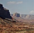
 West aspect | |
| Highest point | |
| Elevation | 5,441 ft (1,658 m) [1] |
| Prominence | 1,193 ft (364 m) [1] |
| Isolation | 5.54 mi (8.92 km) [2] |
| Coordinates | [ ⚑ ] : 36°17′59″N 112°42′22″W / 36.2996302°N 112.7059934°W [3] |
| Geography | |
Lua error in Module:Location_map at line 522: Unable to find the specified location map definition: "Module:Location map/data/Arizona" does not exist.
| |
| Country | United States |
| State | Arizona |
| County | Coconino |
| Protected area | Grand Canyon National Park |
| Parent range | Coconino Plateau[1] Colorado Plateau |
| Topo map | USGS Havasu Falls |
| Geology | |
| Age of rock | Permian |
| Type of rock | limestone, sandstone |
| Climbing | |
| First ascent | 1960 |
| Easiest route | class 5.1 climbing[2] |
Mount Sinyella is a 5,441-foot-elevation (1,658-meter) summit located in the western end of Grand Canyon National Park, in Coconino County of northern Arizona, in the Southwestern United States.[3] It is situated 1.7 miles (2.7 km) north-northwest of Uqualla Point, and four miles (6.4 km) southeast of Boysag Point, at the mouth of Havasu Canyon. As the high point of Sinyella Mesa, it towers 1,200 feet above the mesa, and 3,600 feet above the nearby Colorado River which is 1.5 mile to the northwest.
This isolated butte is an erosional remnant composed of Permian Kaibab Limestone and Coconino Sandstone.[4] This sandstone, which is the third-youngest stratum in the Grand Canyon, was deposited 265 million years ago as sand dunes. According to the Köppen climate classification system, Mount Sinyella is located in a Cold semi-arid climate zone.[5]
History
This butte's name was adopted as Mount Sinyala in 1932 by the U.S. Board on Geographic Names. In 1988, the board officially revised it to the present spelling, Sinyella.[3] It was named by the American conservationist Charles Sheldon for Chief Sinyella (1853–1923), a prominent Havasupai chief who Sheldon hired as a guide to show him the canyon in 1912.[3][6] "It is interesting to go with him [Sinyala], he knows every foot of the country" noted Sheldon.[7] The local native inhabitants called it "Week-eel-eela" which is said to mean "stick sitting up", also their general term for any butte.[8]
The first ascent of the summit was made April 11, 1960, by Don Myers, Mike Sherrick, Jim Wilkerson, and Bill Amborn via the north face.[4] The second ascent was made by Dave Ganci and Jerry Robertson, May 3, 1969.[9]
Gallery
-
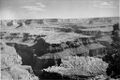 Sinyella Mesa from Boysag Point, with Mt. Sinyella upper left. circa 1951
 -
 Southwest aspect, circa 1949
 -
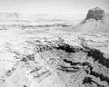
 Mt. Sinyella centered, Sinyella Canyon to left
 -
 from Boysag Point, circa 1951
 -
-
 Mount Sinyella (left) and Paguekwash Point (right) from Kanab Point
 -
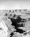
 Mt. Sinyella, east aspect
.jpg)
.jpg)
.jpg)
.jpg)


See also
- Geology of the Grand Canyon area
- History of the Grand Canyon area
- Paguekwash Point
- Fishtail Mesa
References
- ↑ 1.0 1.1 1.2 "Mount Sinyella, Arizona". http://www.peakbagger.com/peak.aspx?pid=3911.
- ↑ 2.0 2.1 "Mount Sinyella – 5,441' AZ". https://listsofjohn.com/peak/74751.
- ↑ 3.0 3.1 3.2 3.3 "Mount Sinyella". United States Geological Survey. https://geonames.usgs.gov/apex/f?p=gnispq:3:::NO::P3_FID:11368.
- ↑ 4.0 4.1 North America, United States, Arizona, Mount Sinyala, Americanalpineclub.org
- ↑ Peel, M. C.; Finlayson, B. L.; McMahon, T. A. (2007). "Updated world map of the Köppen−Geiger climate classification". Hydrol. Earth Syst. Sci. 11. ISSN 1027-5606.
- ↑ United States Board on Geographic Names, Decisions on Geographic Names in the United States, Decision List No. 8804, 1988, page 2.
- ↑ Karl Jacoby, Crimes Against Nature, 2001, University of California Press, page 267.
- ↑ Gregory McNamee, Grand Canyon Place Names, 1997, Mountaineers Publisher, ISBN 9780898865332, page 102.
- ↑ Grandcanyonhistory.org
External links
- Weather forecast: National Weather Service
- Mt. Sinyella photo from river level
- Mount Sinyella pronunciation
Template:Geology of the Grand Canyon area
 |  |

