Earth:Northeastern Highlands (ecoregion)
| Northeastern Highlands Ecoregion | |
|---|---|
 | |
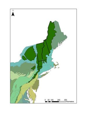 Northeastern Highlands region denoted in forest green | |
| Ecology | |
| Realm | Nearctic |
| Biome | temperate broadleaf forest |
| Borders | Script error: No such module "Compact list". |
| Geography | |
| Area | 122,406.62 km2 (47,261.46 sq mi) |
| Country | Script error: No such module "Compact list". |
| Northeastern United States | Script error: No such module "Compact list". |
| Elevation | 365 meters |
| Coordinates | 42°N, -73°W |
| Climate type | Warm summer humid continental |
| Soil types | Spodosols |
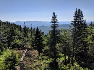
The Northeastern Highlands ecoregion is a Level III ecoregion designated by the United States Environmental Protection Agency (EPA) in the U.S. states of Vermont, New Hampshire, Massachusetts , Maine, Connecticut, New York, New Jersey, and Pennsylvania. The ecoregion extends from the northern tip of Maine and runs south along the Appalachian Mountain Range into eastern Pennsylvania. Discontiguous sections are located among New York's Adirondack Mountains and the Catskill Range. The largest portion of the Northeastern Highlands ecoregion encompasses several sub mountain ranges including the Berkshires, Green Mountains, Taconic, and White Mountains.
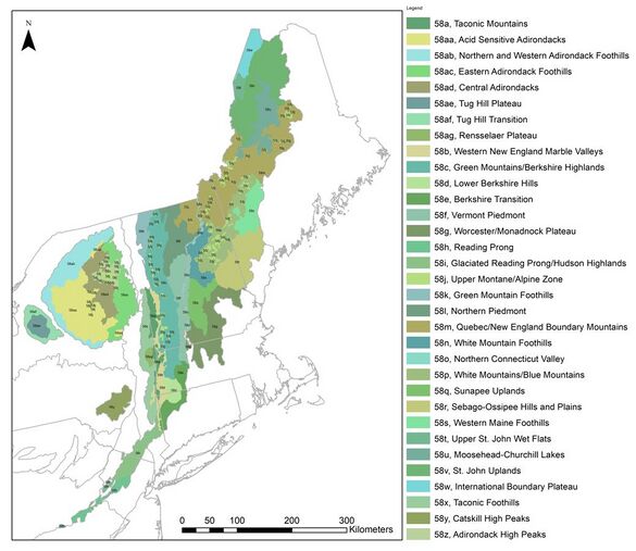
The mountainous region is underlain by metamorphic rock and glacial till. The ecoregion is flanked by several others including the: Acadian Plains and Hills, Eastern Great Lakes Lowlands, Northeastern Coastal Zone, Northern Allegheny Plateau, Ridge and Valley, and Northern Piedmont ecoregions.[1] The elevation generally ranges from 182 meters (600 ft) to 1916.6 meters (6288.2 ft) at the top of Mt. Washington, the region's most elevated and most prominent point. The region is characterized by hot humid summers and cold snowy winters. The nutrient poor Spodosols and other cryic soil types of the region support boreal (north) and broadleaf (south) forests that cover the majority of the region. Ecotourism, forestry, and agriculture are the predominant land uses of the sparsely populated region.[2] Though much of the region was once cleared to make farmland, much of it has reverted into natural forested areas; to a lesser extent, dairy and crops are still grown in lowland valleys and beef cattle on upland pastures. The ecoregion has been subdivided into thirty-three Level IV ecoregions.[2]
Animals of the area include black bears, white-tailed deer, moose, bobcats, coyotes, skunks, raccoons, chipmunks, squirrels, opossum, fisher cats, eastern turkey, bobwhite quail, ducks, and hawks.[3]
Level IV Ecoregions
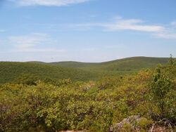
58a. Taconic Mountains
58aa. Acid Sensitive Adirondacks
File:Upper Cascade Lake, Adirondack Mountains-LCCN2008679632.tif The Acid Sensitive Adirondacks derive their name from the underlying bedrock which has a low acid-neutralizing capacity and is one of the regions of the Northeastern Highlands that has been most affected by acid rain. The Acid Sensitive Adirondacks comprises the largest level IV region of the Adirondack Mountain range. Acid rain has acidified the region's lakes to the point where they are uninhabitable for fish; terrestrial effects of acid rain have resulted in leaching of calcium and release of aluminum, which has resulted in tree mortality. Tree cover in the region is dominated by conifers including red, white, and black spruce, as well as balsam fir, red maple, yellow birch, and black cherry.[4][5]
58ab. Northern and Western Adirondack Foothills
58ac. Eastern Adirondack Foothills
58ad. Central Adirondacks
58ae. Tug Hill Plateau
58af. Tug Hill Transition
58ag. Rensselaer Plateau
58b. Western New England Marble Valleys
58c. Green Mountains/Berkshire Highlands
The Green Mountains (Vermont)/Berkshire Highlands (Massachusetts) are part of the same level IV ecoregion, but are defined by different names per their political state boundaries. The region is dominated by steep mountainsides with prominence up to 764 meters (2,500 feet). Like most of the Northeastern Highlands ecoregion, the bedrock consists of metamorphic and glacial till and the soils are acidic, coarse, and low in nutrients. The area is primarily second growth forest, which has returned as a mixed conifer and hardwood stand. Common tree species include red oak, sugar maple, American beech, yellow birch, eastern hemlock, white pine, white ash, basswood, tamarack, black spruce, balsam fir, and white birch.[6]
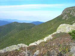
This region includes the towns of Killington, Waterbury, and Stowe, Vermont, and Charlemont, Massachusetts. The primary land use includes active tourism, such as skiing, hiking, biking, and snowmobiling, as well as forestry, maple syrup production, cattle, and hay production.[6][7] This region is also home to several state parks and national woodlands including the Green Mountain National Forest, Calvin Coolidge, Camels Hump, Mount Mansfield, and Okemo State Forests, and Woodford, Molly Stark, Lake Shaftsbury, Fort Dummer, Emerald Lake, Lowell Lake, Lake St. Catherine, Camp Plymouth, Mount Ascutney, Wilgus, and Hazen's Notch state parks.
58d. Lower Berkshire Hills
58e. Berkshire Transition
58f. Vermont Piedmont
58g. Worcester/Monadnock Plateau
58h. Reading Prong
58i. Glaciated Reading Prong/Hudson Highlands
58k. Green Mountain Foothills
58l. Northern Piedmont
The Northern Piedmont ecoregion in Vermont is distinguished from the Vermont Piedmont by it northern location and associated colder climate. It is sometimes referred to as the Northern Vermont Piedmont and is distinct from the Northern piedmont ecoregion extending from New York to Virginia. Bedrock in this Vermont region is mostly limestone, phyllite, mica, schist, quartzite, and slate, with lesser areas composed of granite gneiss; hence it is different from surrounding granite mountain ranges. The Northern Piedmont is mountainous with large open valleys, making it better suited to farming than the hillier terrain of the neighboring Green Mountains, though the colder climate means that cropping or grazing seasons are short (100-140 growing days). The climate is more seasonal than in the southerly humid continental range, with a seasonal summer monsoon which is twice that of winter snowfall. Trees in the region are similar to those in the Green Mountains, wherein northern hardwoods dominate on lower elevation terrain and mixed hardwood and hemlock or spruce–fir forests are supported on upland terrain.

Agriculture abounds in the Northeast Kingdom and commonly includes production of hay, cattle corn, oats, vegetables, and grazing land. The area is sparsely populated, but includes Vermont's capitol, Montpelier (the least populated state capital in the US) and the city of Barre. Brighton State Park is located in the Northern Piedmont. This area and the Quebec/New England Boundary Mountains support the most moose in Vermont and New Hampshire.[8]
58m. Quebec/New England Boundary Mountains
58o. Northern Connecticut Valley
58q. Sunapee Uplands
58r. Sebago-Ossipee Hills and Plains
58s. Western Maine Foothills
58t. Upper St. John Wet Flats
58u. Moosehead-Churchill Lakes
58v. St. John Uplands
58w. International Boundary Plateau
58x. Taconic Foothills
58y. Catskill High Peaks
58z. Adirondack Peaks
References
- ↑ "Level III Ecoregions of the Continental United States". June 17, 2021. https://gaftp.epa.gov/EPADataCommons/ORD/Ecoregions/us/Eco_Level_III_US.pdf.
- ↑ 2.0 2.1 Griffith, G.E., Omernik, J.M., Bryce, S.A., Royte, J., Hoar, W.D., Homer, J.W., Keirstead, D., Metzler, K.J., and Hellyer, G., 2009, Ecoregions of New England (color poster with map, descriptive text, summary tables, and photographs): Reston, Virginia, U.S. Geological Survey (map scale 1:1,325,000).
- ↑ "Northeastern Highland Biophysical Region Check List" (in en). https://inaturalist.ca/check_lists/86487-Northeastern-Highland-Biophysical-Region-Check-List?page=2.
- ↑ Griffith, Glenn E.; Omernik, James M.; Johnson, Colleen Burch; Turner, Dale S. (2014). "Ecoregions of Arizona (poster)". Open-File Report. doi:10.3133/ofr20141141. ISSN 2331-1258. http://dx.doi.org/10.3133/ofr20141141.
- ↑ "Acid Sensitive Adirondacks" (in en). https://bplant.org/region/768.
- ↑ 6.0 6.1 "Green Mountains/Berkshire Highlands" (in en). https://bplant.org/region/776.
- ↑ Griffith, Glenn E.; Omernik, James M.; Johnson, Colleen Burch; Turner, Dale S. (2014). "Ecoregions of Arizona (poster)". Open-File Report. doi:10.3133/ofr20141141. ISSN 2331-1258. http://dx.doi.org/10.3133/ofr20141141.
- ↑ "Moose population in North America" (in en). http://www.ecoclimax.com/2018/11/size-of-us-states-scaled-by-moose.html.
