Earth:The Castle (Utah)
| The Castle | |
|---|---|
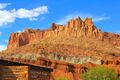
 The Castle, south aspect | |
| Highest point | |
| Elevation | 6,387 ft (1,947 m) [1] |
| Prominence | 327 ft (100 m) [1] |
| Parent peak | Peak 6700[1] |
| Isolation | 0.52 mi (0.84 km) [1] |
| Coordinates | [ ⚑ ] : 38°17′55″N 111°15′51″W / 38.2986188°N 111.2640679°W [2] |
| Geography | |
 The Castle Location in Utah  The Castle The Castle (the United States) | |
| Location | Capitol Reef National Park Wayne County, Utah, United States |
| Parent range | Colorado Plateau |
| Topo map | USGS Twin Rocks |
| Geology | |
| Age of rock | Triassic |
| Type of rock | Wingate Sandstone |
| Climbing | |
| Easiest route | class 5+ climbing[1] |
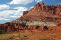
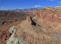
The Castle is a 6,387-foot (1,947-meter) elevation summit located in Capitol Reef National Park, in Wayne County of Utah, United States.[2] This iconic landmark is situated 0.5 mi (0.80 km) immediately north of the park's visitor center, towering nearly 800 feet (240 meters) above the center and Highway 24. Precipitation runoff from this feature is drained by tributaries of the Fremont River.
Geology
The uppermost portion of The Castle is composed of hard, jointed Wingate Sandstone, which is great for rock climbing, and is believed to have formed about 200 million years ago. This overlays the exposed gray-green layer of the Chinle Formation which was laid down as volcanic ash about 225 million years ago, and beneath Chinle is the Moenkopi Formation (about 245 million years old), all of which date to the Triassic.[3] Long after the sedimentary rocks were deposited, the Colorado Plateau was uplifted relatively evenly, keeping the layers roughly horizontal, but Capitol Reef is an exception because of the Waterpocket Fold, a classic monocline, which formed between 50 and 70 million years ago during the Laramide Orogeny.[4]
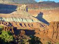
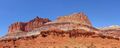
Gallery
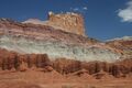
West aspect. Grayish strata is Chinle Formation, brown layer (bottom) is Moenkopi
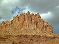
Casting shadow at sunset, from Sunset Point
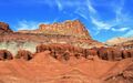
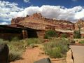
From visitor center
Looking down at The Castle, from the east.


.jpg)


Climate
Spring and fall are the most favorable seasons to visit The Castle. According to the Köppen climate classification system, it is located in a Cold semi-arid climate zone, which is defined by the coldest month having an average mean temperature below 32 °F (0 °C), and at least 50% of the total annual precipitation being received during the spring and summer. This desert climate receives less than 10 inches (250 millimeters) of annual rainfall, and snowfall is generally light during the winter. Script error: No such module "weather box".
See also
References
- ↑ 1.0 1.1 1.2 1.3 1.4 "Castle, The - 6,387' UT". https://listsofjohn.com/peak/22248. Retrieved 2020-09-25.
- ↑ 2.0 2.1 U.S. Geological Survey Geographic Names Information System: The Castle
- ↑ Capitol Reef's Castle, USGS.gov
- ↑ Capitol Reef Geology, NPS.gov
- ↑ "PRISM Climate Group, Oregon State University". http://prism.oregonstate.edu/explorer/.
External links
- Capitol Reef National Park National Park Service
- The Castle: Weather forecast
 |

