Earth:Upper Flood Swallet
From HandWiki
Short description: Limestone cave in Somerset, England
| Upper Flood Swallet | |
|---|---|
 | |
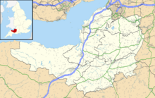
| Location | Charterhouse, Somerset, UK |
| OS grid | ST 50570 55765 |
| Coordinates | [ ⚑ ] 51°17′56″N 2°42′37″W / 51.29885°N 2.71037°W |
| Depth | 110m |
| Length | 4.1km |
| Discovery | 3 October 1968[1] |
| Geology | Limestone |
| Entrances | 1 |
| Difficulty | Extensive system with tight strenuous sections |
| Access | Leader controlled by Mendip Caving Group; experienced cavers only |
| Cave survey | MCG Upper Flood Survey 2012 |
| Registry | Mendip Cave Registry[2] |
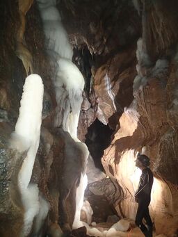
Upper Flood Swallet which was originally known as Blackmoor Flood Swallet, is an exceptionally well-decorated cave near Charterhouse, in the carboniferous limestone of the Mendip Hills, in Somerset, England . The cave is part of the Cheddar Complex SSSI.
The entrance was revealed in the Great Flood of 1968,[3] giving the cave its name.[4] It was dug consistently since then with breakthroughs occurring in 1971, 1972, 1985 and 2006.[1]
As of September 2008 it is over 3.5 km in length and around 125 m deep.[5]
The 2006 breakthrough
In September 2006 cavers squeezed through an excavated boulder choke into new passage. In a series of three digging trips they discovered 1.2 km of well decorated cave.[6]
See also
References
- ↑ 1.0 1.1 Mendip Caving Group
- ↑ "Upper Flood Swallet". Mendip Cave Registry & Archive. http://www.mcra.org.uk/registry/sitedetails.php?id=260. Retrieved 2016-08-29.
- ↑ "Upper Flood Entrance Swallet". Mendip Caving Group. http://www.mendipcavinggroup.org.uk/sections/upperflood/occpub4.html#2b.
- ↑ Witcombe, Richard (2009). Who was Aveline anyway?: Mendip's Cave Names Explained (2nd ed.). Priddy: Wessex Cave Club. p. 189. ISBN 978-0-9500433-6-4.
- ↑ "Mendip". UK and Ireland Cave Lengths and Depths. http://www.ukcaves.co.uk/tables.php?region=2&length_depth=length.
- ↑ Mendip Caving Group
External links
 |


