Earth:Volcanic passive margin
Volcanic passive margins (VPM) and non-volcanic passive margins are the two forms of transitional crust that lie beneath passive continental margins that occur on Earth as the result of the formation of ocean basins via continental rifting. Initiation of igneous processes associated with volcanic passive margins occurs before and/or during the rifting process depending on the cause of rifting. There are two accepted models for VPM formation: hotspots/mantle plumes and slab pull. Both result in large, quick lava flows over a relatively short period of geologic time (i.e. a couple of million years). VPM's progress further as cooling and subsidence begins as the margins give way to formation of normal oceanic crust from the widening rifts.[1]
Characteristics
Despite the differences in origin and formation, most VPMs share the same characteristics:
- 4 to 7 km thick basaltic and (frequently) silicic subaerial flows; dike swarms and sills running parallel to continent-facing normal faults.[1][2]
- 10 to 15 km thick bodies in the lower crust (HVLC) show high seismic P-Wave velocities, between 7.1 and 7.8 km/s which lie under the transitional crust (crust between continental crust and oceanic crust).[2][3]
- Seaward Dipping Reflector (SDR) series: Inner SDRs overlie transitional continental crust. They are composed of varying mixtures of subaerial volcanic flows, volcaniclastic and non-volcanic sediments which range from 50 to 150 km wide and are 5–10 km thick. Outer SDRs overlie transitional oceanic crust and are composed of submarine basaltic flows which range from 3 to 9 km thick.[2][3]
Development

Extensional stress leads to asthenospheric upwelling and Listric Faulting.

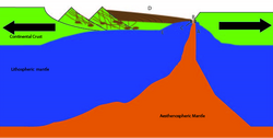
Asthenospheric upwelling, listric faulting, and crustal thinning continue. Mantle convection (A) further weakens lithosphere and leads to the formation of dikes and sills (B). Dikes and sills feed magma chambers in the lower and upper crust (C). Lava erupts as basaltic sheet flows (D).

Thinning crust is strained to the point of breaking, forming a mid-ocean ridge (A). Mantle material upwells to fill the gap at the mid-ocean ridge (B) and cools to form oceanic crust (C). Volcanic sheet flows atop transitional oceanic crust form outer seaward dipping reflectors (D). Convecting mantle material along base of transitional crust cools to form HVLC (E).

Extension thins the crust. Magma reaches the surface through radiating sills and dikes, forming basalt flows, as well as deep and shallow magma chambers below the surface. The crust gradually sink due to thermal subsidence, and originally horizontal basalt flows are rotated tosees become seaward dipping reflectors.
Rift initiation
Active rifting
The active rift model sees rupture driven by hotspot or mantle plume activity. Upwellings of hot mantle, known as mantle plumes, originate deep in Earth and rise to heat and thin the lithosphere. Heated lithosphere thins, weakens, rises, and finally rifts, Enhanced melting following continental breakup is very important in VPMs, creating thicker than normal oceanic crust of 20 to 40 km thick.[1] Other melts caused by convection related upwelling form reservoirs of magma from which dike swarms and sills eventually radiate to the surface, creating the characteristic seaward dipping lava flows. This model is controversial.[1][2][4][5]
Passive rifting
The passive rift model infers that slab pull stretches the lithosphere and thins it. To compensate for lithospheric thinning, asthenosphere upwells, melts due to adiabatic decompression, and derivative melts rise to the surface to erupt. Melts push up through faults towards the surface, forming dikes and sills.[1][2][3][4][5][6]
Development of transitional crust
Continued extension leads to accelerated igneous activity, including repeated eruptions. Repeated eruptions form a thick sequence of lava beds that can reach a combined thickness of up to 20 km. These beds are identified on seismic refraction sections as seaward dipping reflectors. It is important to note that the early phase of volcanic activity is not limited to the production of basalts. Rhyolite and other felsic rocks can also be found in these zones.[2][3][5]
Continued extension with volcanic activity forms transitional crust, welding ruptured continent to nascent ocean floor. Volcanic beds cover the transition from thinned continental crust to oceanic crust. Also occurring during this phase is the formation of high velocity seismic zones under the thinned continental crust and the transitional crust. These zones are identified by typical seismic velocities between 7.2 and 7.7 km/s and are usually interpreted as layers of mafic to ultramafic rocks that have underplated the transitional crust.[2][3][5] Asthenospheric upwelling leads to the formation of a mid-ocean ridge and new oceanic crust progressively separates the once-conjoined rift halves. Continued volcanic eruptions spread lava flows across transitional crust and onto oceanic crust. Due to the high rate of magmatic activity the new oceanic crust forms much thicker than typical oceanic crust. Some have theorized that the copious amounts of volcanic material also lead to the formation of oceanic plateaus at this time.
Post-rift
The final and longest phase is the continued thermal subsidence of the transitional crust and the accumulation of sediments. Continued seafloor spreading leads to the formation of oceanic crust of normal thickness. Over time this production of normal oceanic crust and sea floor spreading leads to the formation of an ocean.[2] This phase is of the most interest to the oil industry and sedimentary geologists.
Distribution and examples
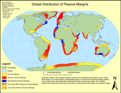
The distribution of known volcanic margins is shown on the graphic to the right. Many of the margins have not been thoroughly investigated and more passive margins are identified as volcanic from time to time.
Volcanic passive margins:
- South Atlantic
- Western Australia
- Southwest India
- West Greenland
- East Greenland
- Northern Labrador Sea
- South of Arabia
- Norwegian Margin
- US Atlantic Margin

VPM example: The US Atlantic Margin
The US Atlantic passive margin extends from Florida to southern Nova Scotia. This VPM was a result of the breakup of the supercontinent, Pangea, in which North America separated from northwestern Africa and Iberia to form the North Atlantic Ocean. This margin has a typical history of tectonic events that are representative of volcanic passive margins with rifting and passive margin formation occurring 225-165 million years ago. Like other VPMs the US East Coast Margin developed in two stages: First, rifting, initiated during the Middle to Late Triassic and continued into Jurassic time and, second, seafloor spreading, which began in Jurassic time and continues today. The US East Coast includes several components which are characteristic of VPM's including seaward-dipping reflectors, flood basalts, dikes, and sills.
References
- ↑ 1.0 1.1 1.2 1.3 1.4 Geoffroy, Laurent (2005). "Volcanic passive margins". Comptes Rendus Geoscience 337 (16): 1395–1408. doi:10.1016/j.crte.2005.10.006. Bibcode: 2005CRGeo.337.1395G. https://comptes-rendus.academie-sciences.fr/geoscience/articles/10.1016/j.crte.2005.10.006/.
- ↑ 2.0 2.1 2.2 2.3 2.4 2.5 2.6 2.7 Marten A., Menzies (2002). "Characteristics of volcanic rifted margins". Geological Society of America Special Paper 362: 1–14.
- ↑ 3.0 3.1 3.2 3.3 3.4 Okay, Nilgün (1995). Thermal development and rejuvenation of the marginal plateaus along the transtensional volcanic margins of the Norwegian–Greenland Sea. The City University of New York.
- ↑ 4.0 4.1 Gernigon, Laurent (20 March 2005). "Norwegian Volcanic Margin". http://www.mantleplumes.org/VM_Norway.html.
- ↑ 5.0 5.1 5.2 5.3 Coffin, Millard F.; Olav Eldholm (February 1994). "Large igneous provinces: Crustal structure, dimensions, and external consequences". Reviews of Geophysics 32 (1): 1–36. doi:10.1029/93RG02508. Bibcode: 1994RvGeo..32....1C.
- ↑ Mutter, John C. (February 10, 1988). "Convective Partial Melting: A Model for the Formation of Thick Basaltic Sequences During the Initiation of Spreading". Journal of Geophysical Research 93 (B2): 1031–1048. doi:10.1029/JB093iB02p01031. Bibcode: 1988JGR....93.1031M.
 |

