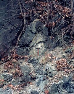
Earth:Wills Creek Formation
| Wills Creek Formation Stratigraphic range: Silurian | |
|---|---|
 Tight anticlinal fold in the Wills Creek Formation, along Route 22, Neff, Huntingdon County, Pennsylvania | |
| Type | sedimentary |
| Underlies | Tonoloway Formation |
| Overlies | Bloomsburg Formation and Williamsport Formation |
| Lithology | |
| Primary | Sandstone, shale |
| Other | Siltstone, limestone, dolomite |
| Location | |
| Region | Appalachian Mountains |
| Extent | Pennsylvania, Maryland, Virginia, West Virginia |
| Type section | |
| Named for | Wills Creek at Cumberland, Allegany County, Maryland |
| Named by | P. R. Uhler, 1905[1] |
Wills Creek Formation is a mapped Silurian bedrock unit in Pennsylvania, Maryland, Virginia, and West Virginia.
Description
The Wills Creek is defined as a moderately well bedded greenish-gray shale containing local limestone and sandstone zones, or more specifically as an olive to yellowish-gray, thin-bedded sandstone, calcareous shale, dolomite, argillaceous limestone, and sandstone. Red shale and siltstone occur in the lower part of the formation. The formation has a thickness between 450 feet and 600 feet in Maryland and 445 to 620 feet in Pennsylvania.[2]
The Wills Creek forms the bedrock of the valley around and to the east of Lewistown, Pennsylvania.[3]
Fossils
The Wills Creek Limestone contain fossils from the Pridoli to the Ludlow epoch, or 422.9 to 418.1 Ma.[4]
Dean et al. (1985) describe the Wills Creek as sparsely fossiliferous.[5]
Conodonts have been identified in the Wills Creek in Virginia (Ozarkodina snajdri crispa Zone).[6]
Notable outcrops
- Type section at Wills Creek at Cumberland, Allegany County, Maryland
- Roundtop Hill, Maryland, along railroad grade
Age
Relative age dating of the Wills Creek places it in the Silurian period. It rests conformably a top the Bloomsburg Formation and below the Tonoloway Formation.[7]
Economic use
The Wills Creek is a poor source of construction material and is only suitable as common fill.[8]
See also
- Geology of Pennsylvania
References
- ↑ Uhler, P.R., 1905, The Niagara period and its associates near Cumberland, Maryland: Maryland Academy of Science Transactions, v. 2, p. 19-26.
- ↑ "Table 1. Paleozoic Stratigraphic Section in Central Pennsylvania". Geological Report On The Skytop Road Cuts. Pennsylvania State University Department of Geosciences. 2004. http://www.geosc.psu.edu/news/features/gold/Final%20report%20%20Gold%20&%20Doden/Final%20Tables/Table%201%20Strat%20section.pdf.
- ↑ McElroy, Thomas A. (2004). Bedrock Geologic Map of the Lewistown Quadrangle, Mifflin and Juniata Counties, Pennsylvania (PDF) (Map). Pennsylvania Geological Survey. Archived from the original (pfd) on March 28, 2006.
- ↑ "Wills Creek Limestone Formation". The Paleobiology Database. Advisory Board of the Paleobiology Database. http://paleodb.org/cgi-bin/bridge.pl?action=displayStrata&group_hint=&group_formation_member=Wills%20Creek%20Limestone.
- ↑ Dean, S.L., Kulander, B.R., and Lessing, Peter, 1985, Geology of the Capon Springs, Mountain Falls, Wardensville, Woodstock, and Yellow Springs quadrangles, Hampshire and Hardy Counties, West Virginia: West Virginia Geological and Economic Survey Map, 26, 1 sheet, scale 1:24,000
- ↑ Harris, A.G., Stamm, N.R., Weary, D.J., Repetski, J.E., Stamm, R.G., and Parker, R.A., 1994, Conodont color alteration index (CAI) map and conodont-based age determinations for the Winchester 30' x 60' quadrangle and adjacent area, Virginia, West Virginia, and Maryland: U.S. Geological Survey Miscellaneous Field Studies Map, MF-2239, 40 p., 1 sheet, scale 1:100,000 [1]
- ↑ "Allegheny Plateau and Valley and Ridge". Geologic Map of Maryland. Maryland Geological Survey. 1968. http://www.mgs.md.gov/esic/geo/lgdalleg.html.
- ↑ Doden, Arnold G.; Gold, David P. (2008). Bedrock Geologic Map of The Mc Alevys Fort Quadrangle, Huntingdon, Centre, and Mifflin Counties, Pennsylvania. Pennsylvania Geological Survey. http://www.dcnr.state.pa.us/topogeo/openfile/mcalevysfort.pdf.
 |

