Hypocenter
A hypocenter or hypocentre (from grc ὑπόκεντρον (hupókentron) 'below the center'), also called ground zero or surface zero, is the point on the Earth's surface directly below a nuclear explosion, meteor air burst, or other mid-air explosion. In seismology, a hypocenter of an earthquake is its point of origin below ground; a synonym is the focus of an earthquake.[1]
Generally, the terms ground zero and surface zero are also used in relation to epidemics, and other disasters to mark the point of the most severe damage or destruction. The term is distinguished from the term zero point in that the latter can also be located in the air, underground, or underwater.[2]
Trinity, Hiroshima and Nagasaki


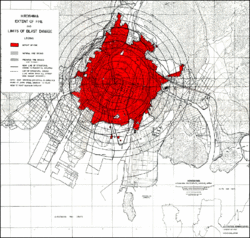
The term "ground zero" originally referred to the hypocenter of the Trinity test in Jornada del Muerto desert near Socorro, New Mexico, and the atomic bombings of Hiroshima and Nagasaki in Japan . The United States Strategic Bombing Survey of the atomic attacks, released in June 1946, used the term liberally, defining it as:
For convenience, the term 'ground zero' will be used to designate the point on the ground directly beneath the point of detonation, or 'air zero.'[3]
William Laurence, an embedded reporter with the Manhattan Project, reported that "Zero" was "the code name given to the spot chosen for the [Trinity] test" in 1945.[4]
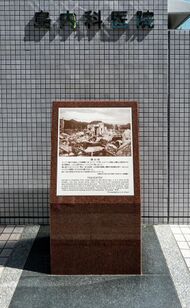
The Oxford English Dictionary, citing the use of the term in a 1946 New York Times report on the destroyed city of Hiroshima, defines ground zero as "that part of the ground situated immediately under an exploding bomb, especially an atomic one." The term was military slang, used at the Trinity site where the weapon tower for the first nuclear weapon was at "point zero", and moved into general use very shortly after the end of World War II. At Hiroshima, the hypocenter of the attack was Shima Hospital, approximately 800 ft (240 m) away from the intended aiming point at Aioi Bridge.
The Pentagon

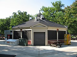
During the Cold War, the Pentagon (headquarters of United States Department of Defense in Arlington County, Virginia) was an assured target in the event of nuclear war. The open space in the center of the Pentagon became known informally as ground zero. A snack bar that used to be located at the center of this open space was nicknamed "Cafe Ground Zero".[5]
World Trade Center

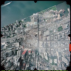
During the September 11 attacks in 2001, two aircraft were hijacked by 10 al-Qaeda terrorists and were flown into the Twin Towers of the World Trade Center in New York City , causing massive damage and starting fires that caused the weakened 110-storey skyscrapers to collapse. The destroyed World Trade Center site soon became known as "ground zero". Rescue workers also used the term "The Big Momma!", referring to the pile of rubble that was left after the buildings collapsed.[6]
Even after the site was cleaned up and construction on the new One World Trade Center and the National September 11 Memorial & Museum were well under way, the term was still frequently used to refer to the site, as when opponents of the Park51 project that was to be located two blocks away from the site labeled it the "Ground Zero mosque".
In advance of the 10th anniversary of the attacks, New York City mayor Michael Bloomberg urged that the "ground zero" moniker be retired, saying, "…the time has come to call those 16 acres [6.5 hectares] what they are: The World Trade Center and the National September 11th Memorial and Museum."[7]
Meteor air bursts
The hypocenter of a meteor air burst, an asteroid or comet that explodes in the atmosphere rather than strike the surface, is the closest point on the surface to the explosion. The Tunguska event occurred in Siberia in 1908 and flattened an estimated 80 million trees over an area of 2,150 km2 (830 sq mi) of forest. The trees at the hypocenter of the blast were left standing, but all their limbs had been blown off by the shockwave. The 2013 Chelyabinsk meteor's hypocenter in Russia was more populated than that of Tunguska, resulting in civil damage and injury, mostly from flying glass shards from broken windows.[8]
Earthquakes
| Part of a series on |
| Earthquakes |
|---|

An earthquake's hypocenter is the position where the strain energy stored in the rock is first released, marking the point where the fault begins to rupture.[1] This occurs directly beneath the epicenter, at a distance known as the hypocentral depth or focal depth.[1]
The focal depth can be calculated from measurements based on seismic wave phenomena. As with all wave phenomena in physics, there is uncertainty in such measurements that grows with the wavelength so the focal depth of the source of these long-wavelength (low frequency) waves is difficult to determine exactly. Very strong earthquakes radiate a large fraction of their released energy in seismic waves with very long wavelengths and therefore a stronger earthquake involves the release of energy from a larger mass of rock.
Computing the hypocenters of foreshocks, main shock, and aftershocks of earthquakes allows the three-dimensional plotting of the fault along which movement is occurring.[9] The expanding wavefront from the earthquake's rupture propagates at a speed of several kilometers per second; this seismic wave is what is measured at various surface points in order to geometrically determine an initial guess as to the hypocenter. The wave reaches each station based upon how far away it was from the hypocenter. A number of things need to be taken into account, most importantly variations in the waves speed based upon the materials that it is passing through.[10] With adjustments for velocity changes, the initial estimate of the hypocenter is made, then a series of linear equations is set up, one for each station. The equations express the difference between the observed arrival times and those calculated from the initial estimated hypocenter. These equations are solved by the method of least squares which minimizes the sum of the squares of the differences between the observed and calculated arrival times, and a new estimated hypocenter is computed. The system iterates until the location is pinpointed within the margin of error for the velocity computations.[10]
See also
- List of meteor air bursts
- List of nuclear weapon explosion sites
- Tenet, a 2020 film that includes a sub-surface nuclear "hypocenter" in its storyline
References
- ↑ 1.0 1.1 1.2 The hypocenter is the point within the earth where an earthquake rupture starts. The epicenter is the point directly above it at the surface of the Earth. Also commonly termed the focus. "Earthquake Glossary – hypocenter". United States Geological Survey. https://earthquake.usgs.gov/learn/glossary/?term=hypocenter.
- ↑ "U.S. DoD Terminology: zero point". http://www.militaryfactory.com/dictionary/military-terms-defined.asp?term_id=5818.
- ↑ U.S. Strategic Bombing Survey: The Effects of the Atomic Bombings of Hiroshima and Nagasaki . June 19, 1946. President's Secretary's File, Truman Papers. Page 5.
- ↑ William L. Laurence, Dawn over Zero (London: Museum Press, 1947), 4.
- ↑ 5.0 5.1 "Pentagon Hot Dog Stand, Cold War Legend, to be Torn Down". United States Department of Defense. September 20, 2006. http://archive.defense.gov/news/newsarticle.aspx?id=1049. "'It's rumored that a portion of their (Soviet) nuclear arsenal was directed at that building, the Pentagon hot dog stand,' tour guides tell visitors as they pass the stand. 'This is where the building earned the nickname Cafe Ground Zero, the deadliest hot dog stand in the world.'"
- ↑ Hamill, Denis (16 September 2001). "Rescue Workers Keep Up Quest for Signs of Life Ruin All Over, But Not One Unkind Word". Daily News (New York).
- ↑ Geoghegan, Tom (2011-09-07). "Is it time to retire 'Ground zero'?". BBC. https://www.bbc.co.uk/news/magazine-14827694.
- ↑ "Пострадавшую при падении метеорита перевезут из Челябинска в Москву" (in ru). 16 February 2013. https://ria.ru/20130216/923200576.html.
- ↑ "Using GIS for Visualizing Earthquake Epicenters, Hypocenters, Faults and Lineaments in Montana". Digital Mapping Techniques '00 -- Workshop Proceedings. United States Geological Survey. 2000. http://pubs.usgs.gov/of/2000/of00-325/kennelly.html.
- ↑ 10.0 10.1 "FAQs - Measuring Earthquakes: Q: How do seismologists locate an earthquake?". USGS Earthquake Hazrads Program. United States Geological Survey. https://earthquake.usgs.gov/learn/faq/?categoryID=2&faqID=118/index.html.
External links
Lua error: Internal error: The interpreter exited with status 1.
Lua error: Internal error: The interpreter exited with status 1.