Physics:VNIR
From HandWiki
Short description: Portion of the electromagnetic spectrum between 400–1100 nm

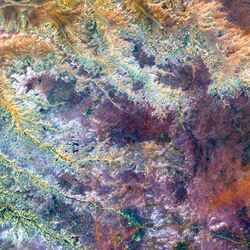
The visible and near-infrared (VNIR) portion of the electromagnetic spectrum has wavelengths between approximately 400 and 1100 nanometers (nm).[1] It combines the full visible spectrum with an adjacent portion of the infrared spectrum up to the water absorption band between 1400 and 1500 nm. Some definitions also include the short-wavelength infrared band from 1400 nm up to the water absorption band at 2500 nm.[2] VNIR multi-spectral image cameras have wide applications in remote sensing and imaging spectroscopy.[3] Hyperspectral Imaging Satellite carried two payloads, among which one was working on the spectral range of VNIR.[4]
See also
- Advanced Spaceborne Thermal Emission and Reflection Radiometer
- Airborne Real-time Cueing Hyperspectral Enhanced Reconnaissance
- Mars Reconnaissance Orbiter
- Near infrared spectroscopy
References
- ↑ Moseley, Trevor; Zabierek, Gus (2006). Guidance On The Safe Use Of Lasers In Education And Research. http://phys.strath.ac.uk/information/safety/LaserSafety/AURPO_guidance_Lasers.pdf. Retrieved 2007-10-31. "electromagnetic radiation at wavelengths extending from 100 nm in the ultra-violet, through the visible (400-700 nm), and the near infrared (700-1400 nm), to the far infrared (1400 nm – 1 mm).".
- ↑ Waiser, T.H.; Morgan, C.L.S.; Brown, D.J.; Hallmark, C.T. (2007). "In Situ Characterization of Soil Clay Content with Visible Near-Infrared Diffuse Reflectance Spectroscopy". Soil Science Society of America Journal 71 (2): 389. doi:10.2136/sssaj2006.0211. Bibcode: 2007SSASJ..71..389W.
- ↑ Ben-dor, E.; Inbar, Y.; Chen, Y. (1997). "Reflectance spectra of organic matter in the visible near-infrared and short wave infrared region(400-2500 nm) during a controlled decomposition process". Remote Sensing of Environment 61 (1): 1–15. doi:10.1016/S0034-4257(96)00120-4. Bibcode: 1997RSEnv..61....1B. http://www.tau.ac.il/humanities/geography/rsl/pdf/eyal_paper/bendor9.pdf. Retrieved 2007-10-31.
- ↑ "HySIS (HyperSpectral Imaging Satellite) - Satellite Missions - eoPortal Directory". https://directory.eoportal.org/web/eoportal/satellite-missions/content/-/article/hysis#:~:text=ISRO%20(Indian%20Space%20Research%20Organization,satellite%20for%20launch%20in%202018.&text=HySIS,%20the%20primary%20satellite%20of,(IMS-2)%20bus..
 |
