Earth:Watervalley Wetlands
| Watervalley Wetlands | |
|---|---|
| Location | Murray and Mallee & Limestone Coast regions South Australia[2] |
| Coordinates | [ ⚑ ] : 36°28′0″S 140°11′0″E / 36.466667°S 140.183333°E[1] |
| Basin countries | Australia |
| Managing agency | Wetlands and Wildlife Trust South Eastern Water Conservation and Drainage Board[1] |
| Designation | Nationally important wetland[1] |
| Surface area | 56.6 square kilometres (21.9 sq mi)[1] |
| Surface elevation | 15 to 35 metres (49 to 115 ft)[1] |
| References | [1] |
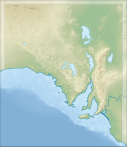
The Watervalley Wetlands is a nationally important wetland system located in the Australian state of South Australia which consists of a series of contiguous wetlands, lying on 56.6 square kilometres (21.9 sq mi) of private land[1] between the Coorong National Park and Gum Lagoon Conservation Park, in the state's south-east.[2]
Description
The wetlands comprise Mandina Marshes, Mandina Lake, Cortina Lakes, Mrs Whites Lagoon, Caora and South Flagstaff, which form a chain between relict dune systems inland of the Coorong, about 250 km south-east of Adelaide. The water in the wetlands ranges from fresh to saline according to seasonal conditions. The area has a Mediterranean climate with cool, wet winters and warm, dry summers, and with an average annual rainfall of 450–500 mm. Most of the land is owned by Wetlands & Wildlife, a private conservation and land rehabilitation company, with the remainder expected to become the property of the company in due course.[3]
Fauna
Birds
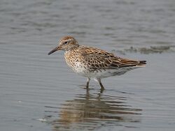
The site has been identified as an Important Bird Area (IBA) by BirdLife International because it supports over 1% of the world populations of sharp-tailed sandpipers, and sometimes of blue-billed and musk ducks, when water levels are suitable. It also provides habitat for diamond firetails.[4] Other birds of conservation significance present at the wetlands include black-backed and Australasian bitterns, freckled ducks, Australasian shovellers, white-bellied sea-eagles, peregrine falcons, Latham's snipes, Baillon's and spotless crakes, yellow-tailed black cockatoos, southern emu-wrens, chestnut-rumped heathwrens, diamond and beautiful firetails, and black-chinned honeyeaters. The wetlands also support large breeding colonies of several thousand ibises, egrets, spoonbills and cormorants.[3]
Flora
The Ramsa site Coorong has been a special site to many species of bird. It has also been a special site for many plants. In particular, one type of plant which has been found to be the main source of food for the birds is Ruppia tuberosa (.[5] The draining and activities made by the European settlers during the colonial days has caused a great impact to the lives of this particular plant along with other aquatic plants that provides a stock for the birds.
Other animals
The site is home to red-necked wallabies and common wombats at the extreme western limit of their range. Rosenberg's goannas are present. Growling grass frogs and Yarra pygmy perch have been recorded.[3]
References
- ↑ 1.0 1.1 1.2 1.3 1.4 1.5 1.6 de Jong, M.C. (1995). "Search result for 'Watervalley Wetlands - SA064'". Australian government. http://www.environment.gov.au/cgi-bin/wetlands/report.pl. Retrieved 28 December 2017.
- ↑ 2.0 2.1 "Search result for Watervalley Wetlands with the following layers selected - 'suburbs', "NPWSA properties', 'State Gov Regions' and 'Wetlands of National Importance'". Government of South Australia. https://data.environment.sa.gov.au/NatureMaps/Pages/default.aspx. Retrieved 21 December 2017.
- ↑ 3.0 3.1 3.2 BirdLife International. (2011). Important Bird Areas factsheet: Watervalley Wetlands. Downloaded from http://www.birdlife.org on 2011-11-21.
- ↑ "Important Bird Areas factsheet: Gum Lagoon". BirdLife International. 2015. http://www.birdlife.org/datazone/sitefactsheet.php?id=26479. Retrieved 17 September 2015.
- ↑ Dick, J; Haynes, D; Tibby, J; Garcia, A (2011). "A history of aquatic plants in the Coorong, a Ramsar-listed coastal wetland, South Australia". J Paleolimnol 46 (4): 623–635. doi:10.1007/s10933-011-9510-4. Bibcode: 2011JPall..46..623D.
External links
 |


