Earth:Restrictions on geographic data in China
Due to national security concerns, the use of geographic information in China is restricted to entities that obtain a special authorization from the administrative department for surveying and mapping under the State Council.[1] Consequences of the restriction include fines for unauthorized surveys, lack of geotagging information on many cameras when the GPS chip detects a location within China, incorrect alignment of street maps with satellite maps in various applications,[2] and seeming unlawfulness of crowdsourced mapping efforts such as OpenStreetMap.[3]
Legislation
According to articles 7, 26, 40 and 42 of the Surveying and Mapping Law of the People's Republic of China, private surveying and mapping activities have been illegal in mainland China since 2002. The law prohibits
publishing, without authorization, significant geographic information and data concerning the territorial air, land and waters, as well as other sea areas under the jurisdiction of the People's Republic of China.
– The National Administration of Surveying, Mapping and Geoinformation of China, Surveying and Mapping Law of the People’s Republic of China
Fines range from 10,000 to 500,000 CNY (1447 – 72359 USD). Foreign individuals or organizations that wish to conduct surveying must form a Chinese-foreign joint venture.[1]
Between 2006 and 2011, the authorities pursued nearly 40 illegal cases of mapping and surveying.[4] The media has reported on other cases of unlawful surveys:
- March 7, 2007 - Japanese and Korean scholars fined; joint-venture Weihai hired foreign surveyors without approval from the government[5]
- March 25, 2008 - China's State Bureau of Surveying and Mapping cracks down on some of the 10,000 websites that publish maps in China, most without authorization.[6]
- January 6, 2009 - Chinese authorities fine UK students for “illegal map-making activities”.[7]
- 2010 - Chinese authorities to crack down on the unregistered or illegal among 42,000 online map providers, targeting incorrect information and leaks of sensitive information involving state secrets. New standards require all Internet map providers to keep servers storing map data inside China.[8]
- March 14, 2014 - Coca-Cola is accused of illegal mapping.[9]
As a consequence, major digital camera manufacturers including Panasonic, Leica, FujiFilm, Nikon and Samsung restrict location information within China.[10]
OpenStreetMap, the crowdsourced project to assemble a map of the world, advises that "private surveying and mapping activities are illegal in China".[11]
Coordinate systems
| Geodesy |
|---|
 |
Technical spatial processing must be applied to electronic navigational maps prior to publication, sales, redistribution, and usage.
– GB 20263―2006 "Basic security processes for electronic navigational maps", 4.1
Chinese regulations mandate that approved map service providers in China use a specific coordinate system, called GCJ-02. Baidu Maps uses yet another coordinate system - BD-09,[12][13] which seems to be based on GCJ-02.[14]
GCJ-02
GCJ-02 (colloquially Mars Coordinates) is a geodetic datum formulated by the Chinese State Bureau of Surveying and Mapping (Chinese: 国测局; pinyin: guó-cè-jú), and based on WGS-84.[15] It uses an obfuscation algorithm[16] which adds apparently random offsets to both the latitude and longitude, with the alleged goal of improving national security.[14][17]
A marker with GCJ-02 coordinates will be displayed at the correct location on a GCJ-02 map. However, the offsets can result in a 100 - 700 meter error from the actual location if a WGS-84 marker (such as a GPS location) is placed on a GCJ-02 map, or vice versa. The Google.com street map is offset by 50–500 meters from its satellite imagery,[9][18] while the Google.cn map is not.[19] Yahoo! Maps also displays the street map without major errors when compared to the satellite imagery.[20] MapQuest overlays OpenStreetMap data perfectly as well.[21]
Despite the secrecy surrounding the GCJ-02 obfuscation, several open-source projects exist that provide conversions between GCJ-02 and WGS-84, for languages including C#,[22] C, Go, Java, JavaScript, PHP,[23] Python,[24] R,[14] and Ruby.[25][26] They appear to be based on leaked code for the WGS to GCJ part.[27] Other solutions to the conversion involve interpolating coordinates based on regression from a data set of Google China and satellite imagery coordinates.[28] An attempt by Wu Yongzheng using FFT analysis gave a result much like the leaked code.[29]
From the leaked code,[22] GCJ-02 uses parameters from the SK-42 reference system. The parameters were used to calculate lengths of one degree of latitude and longitude, so that offsets in meters previously calculated can be converted to degrees for the WGS-84 input coordinates.
BD-09
BD-09 is a geographic coordinate system used by Baidu Maps, adding further obfuscation to the already cryptic GCJ-02 "to better protect users' privacy".[30][13] Baidu provides an API call to convert from Google or GPS (WGS-84) coordinates into Baidu coordinates.[12] Similar to GCJ-02, there are no APIs to convert in the other direction, but open source implementations in R[14] and various other languages[23] exist.
Reverse transformation
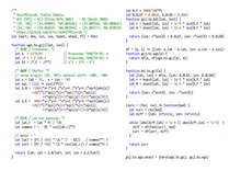
GCJ-02 appears to use multiple high-frequency noises of the form , effectively generating a transcendental equation and thus eliminating analytical solutions. However, the open-source "reverse" transformations make use of the properties of GCJ-02 that the transformed coordinates are not too far from WGS-84 and are mostly monotonic related to corresponding WGS-84 coordinates:[31][14]
from typing import Callable
# Represent coordinates with complex numbers for simplicity
coords = complex
# Coords-to-coords function
C2C = Callable[[coords], coords]

def rev_transform_rough(bad: coords, worsen: C2C) -> coords:
    """
    Roughly reverse the ``worsen`` transformation.

    Since ``bad = worsen(good)`` is close to ``good``,
    ``worsen(bad) - bad`` can be used to approximate ``bad - good``.

    First seen in eviltransform.
    """
    return bad - (worsen(bad) - bad)

def rev_transform(bad: coords, worsen: C2C) -> coords:
    """
    More precisely reverse the ``worsen`` transformation.

    Similar to ``rev_transform_rough``,
    ``worsen(a) - worsen(b)`` can be used to approximate ``a - b``.

    First seen in geoChina/R/cst.R (caijun 2014).
    Iteration-only version (without rough initialization) has been known
    since fengzee-me/ChinaMapShift (November 2013).
    """
    eps = 1e-6
    wgs = rev_transform_rough(bad, worsen)
    improvement = (99+99j) # dummy value

    while abs(improvement) > eps:
        improvement = worsen(wgs) - bad
        wgs = wgs - improvement
    return wgs
The rough method is reported to give some 1~2 meter accuracy for wgs2gcj,[23] while the exact (fixed point iteration) method is able to get "centimeter accuracy" in two calls to the forward function.[note 1][32][31] Since the two properties ensure some basic functionality of the coordinate system, it's unlikely that the methods will change with new coordinate systems. The BD-to-GCJ code works in a manner much like the rough method, except that it removes the explicitly-applied constant shift of ~20 seconds of arc on both coordinates first and works in polar coordinates like the forward function does.[14]
The establishment of working conversion methods both ways largely obsoletes datasets for deviations mentioned below.[33]
The China GPS shift problem

The China GPS shift (or offset) problem is a class of issues stemming from the difference between the GCJ-02 and WGS-84 datums. Global Positioning System coordinates are expressed using the WGS-84 standard and when plotted on street maps of China that follow the GCJ-02 coordinates, they appear off by a large (often over 500 meters) and variable amount. Authorized providers of location-based services and digital maps (such as AutoNavi or NavInfo) must purchase a "shift correction" algorithm that enables plotting GPS locations correctly on the map.[33] Satellite imagery and user-contributed street map data sets, such as those from OpenStreetMap also display correctly because they have been collected using GPS devices (albeit technically illegally - see Legislation).
Some map providers, such as Here, choose to also offset their satellite imagery layer to match the GCJ-02 street map.[34]
Google has worked with Chinese LBS provider AutoNavi since 2006 to source its maps in China.[35] google.cn/maps (formerly Google Ditu) uses the GCJ-02 system for both its street maps[36] and satellite imagery.[37] However, the WGS-84 positions reported by a browser are depicted at the wrong positions. On the contrary, google.com/maps also uses GCJ-02 data for the street map, but doesn't shift the satellite imagery layer, which continues to use WGS-84 coordinates,[38] with the benefit that WGS-84 positions can still be overlaid correctly on the satellite image (but not the street map). Google Earth also uses WGS-84 to display the satellite imagery.[39]
Overlaying GPS tracks on Google.com Maps and any street maps sourced from Google.com via its API, will lead to a similar display offset problem, because GPS tracks use WGS-84, and Google.com maps use GCJ-02. The issue has been reported numerous times on the Google Product Forums since 2009,[40] with 3rd party applications emerging to fix it.[41] Data sets with offsets for large lists of Chinese cities existed for sale.[42] The problem was observed as early as 2008, and the causes were unclear, with (misguided) speculation that imported GPS chips were tampered with code that caused incorrect reporting of coordinates.[43]
Hong Kong and Macau
Under One Country Two Systems, legislation in mainland China does not apply in Hong Kong and Macau SARs and there are no similar restrictions in the SARs. Therefore, the GPS shift problem does not apply. However, at the border between the SARs and mainland China, the data shown by online maps are broken[44] where the shifted data and correct data overlap. This poses problems to users travelling across the border, especially visitors not aware of the issue.
Notes
- ↑ i.e.
wgs -= worsen(wgs) - baddone twice, withwgsinitialized asbadso that the first iteration is equivalent to a rough pass.
References
- ↑ 1.0 1.1 "Surveying and Mapping Law of the People’s Republic of China". National Administration of Surveying, Mapping and Geoinformation of China. http://en.nasg.gov.cn/article/Lawsandregulations/201312/20131200005471.shtml.
- ↑ "Restricciones al trabajo con información geográfica online en China". Universidad de Castilla-La Mancha, Campus Tecnológico Fábrica de Armas, Toledo: JIIDE 2013. 13 November 2013. http://www.idee.es/resources/presentaciones/JIIDE13/miercoles/15_restriscciones_IG_MapasEnChina_presentacion.pdf.
- ↑ "Surveying and Mapping Law of the People’s Republic of China— National Administration of Surveying, Mapping and Geoinformation". http://en.nasg.gov.cn/article/Lawsandregulations/201312/20131200005471.shtml. "Articles 7, 26, 40 and 42"
- ↑ Hvistendahl, M. (24 January 2013). "Foreigners Run Afoul of China's Tightening Secrecy Rules". Science 339 (6118): 384–385. doi:10.1126/science.339.6118.384. PMID 23349263.
- ↑ Dingding, Xin (7 March 2007). "Unlawful surveys to be dealt severely". China Daily. http://www.chinadaily.com.cn/china/2007-03/07/content_821274.htm.
- ↑ Liang, Yan (25 March 2008). "China cracks down on illegal online map services to protect state security". Xinhua News Agency. Beijing. http://news.xinhuanet.com/english/2008-03/25/content_7858467.htm.
- ↑ "China fines UK students for 'illegal map-making'". AFP. 6 January 2009. http://www.chinapost.com.tw/china/national-news/2009/01/06/190764/China-fines.htm.
- ↑ Wang, Guanqun (19 May 2010). "China issues new rules on Internet map publishing". Xinhua News Agency. http://news.xinhuanet.com/english2010/china/2010-05/19/c_13302696.htm.
- ↑ 9.0 9.1 Pasternack, Alex (14 March 2013). "If You're a Foreigner Using GPS in China, You Could Be a Spy". Vice. https://motherboard.vice.com/en_us/article/3ddmzv/if-youre-a-foreigner-in-china-it-is-illegal-to-use-gps.
- ↑ Doctorow, Cory (23 May 2015). "Why your camera's GPS won't work in China (maybe)". Boing Boing. Archived from the original on 24 May 2015. http://boingboing.net/2012/05/24/why-your-cameras-gps-wont.html.
- ↑ "Legality". OpenStreetMap. https://wiki.openstreetmap.org/wiki/WikiProject_China#Legality. Retrieved 7 April 2015.
- ↑ 12.0 12.1 "Coordinate conversion" (in zh). Baidu Maps. http://developer.baidu.com/map/jsdemo.htm#a5_1. Retrieved 7 April 2015.
- ↑ 13.0 13.1 "坐标转换API" (in zh). Baidu. http://developer.baidu.com/map/changeposition.htm.
- ↑ 14.0 14.1 14.2 14.3 14.4 14.5 "A package for geocoding, reverse geocoding and coordinate transformations between WGS-84, GCJ-02 and BD-09 coordinate systems". 15 February 2014. https://github.com/caijun/geoChina.
- ↑ "Quickstart". https://angular-ui.github.io/angular-google-maps/#!/use. Retrieved 7 April 2015.
- ↑ "手机地理轨迹取证步骤大解密". IT168. http://m.it168.com/article_1778861.html.
- ↑ "国内常见的电子地图坐标介绍". 鲲鹏Web数据抓取. http://www.site-digger.com/html/articles/20140115/72.html.
- ↑ "Google.com hybrid map of The Bund". https://www.google.com/maps/place/The+Bund/@31.2417003,121.49003,1096m/data=!3m1!1e3!4m2!3m1!1s0x35b270578b874861:0x4d56fbed10d1af64. Retrieved 7 April 2015.
- ↑ "Google.cn map of The Bund". Google China. http://www.google.cn/maps/@31.2397367,121.4946247,1097m/data=!3m1!1e3.
- ↑ "Yahoo! Map of The Bund". https://maps.yahoo.com/place/?lat=31.24175591400924&lon=121.49212718009949&q=shanghai&bb=31.24629644%2C121.48394644%2C31.23721516%2C121.50030792&addr=shanghai. Retrieved 7 April 2015.
- ↑ "MapQuest map of The Bund". http://mapq.st/1C9QlaP. Retrieved 7 April 2015.
- ↑ 22.0 22.1 "EvilTransform.cs". 2 February 2013. https://on4wp7.codeplex.com/SourceControl/changeset/view/21455#EvilTransform.cs.
- ↑ 23.0 23.1 23.2 "Transform coordinates between Earth (WGS-84) and Mars in China (GCJ-02)". https://github.com/googollee/eviltransform.
- ↑ "China GPS offset problem". http://blog.snapdragon.cc/2013/07/17/china-gps-offset-problem/.
- ↑ "MarsGeo". Omniref. Archived from the original on 16 April 2015. https://web.archive.org/web/20150416161655/https://www.omniref.com/ruby/gems/mars_geo/0.0.1.
- ↑ "EvilTransform Ruby gem". https://rubygems.org/gems/evil_transform/versions/0.0.1.
- ↑ FENG, Zili (6 April 2015). "ChinaMapDeviation". Archived from the original on 7 April 2015. https://web.archive.org/web/20150407111031/https://github.com/maxime/ChinaMapDeviation/issues/1.
- ↑ Guilbot, Maxime (28 May 2013). "ChinaMapDeviation". https://github.com/maxime/ChinaMapDeviation.
- ↑ Wu, Yongzheng. "The Deviation of China Map as a Regression Problem". https://wuyongzheng.github.io/china-map-deviation/paper.html. Retrieved 1 February 2016.
- ↑ "Baidu LBS Open Platform FAQ". Baidu Developer. http://developer.baidu.com/map/question.htm#qa0023. Retrieved 2016-12-19.
- ↑ 31.0 31.1 "中国地图偏移算法" (in zh). Archived from the original on 2017-02-21. https://gist.github.com/anonymous/e7c6f67555099180ce1ae8da4ba2c513.
- ↑ "make gcj2wgs_exact() much faster, by using fixed…". https://github.com/bewantbe/eviltransform/commit/86ae326. Retrieved 29 February 2016.
- ↑ 33.0 33.1 Feng, Zili (7 April 2015). "The government charges Chinese companies for the "shift correction" feature". https://github.com/maxime/ChinaMapDeviation/issues/1#issuecomment-90462107.
- ↑ "Nokia Here street map and satellite map both use GCJ-02 coordinates". https://www.here.com/?map=31.24427,121.48695,18. Retrieved 8 April 2015.
- ↑ Lee, Mark (6 July 2012). "Apple Shares Google China Map Partner in Win for AutoNavi: Tech". Bloomberg. https://www.bloomberg.com/news/articles/2012-07-05/apple-shares-google-china-map-partner-in-win-for-autonavi.
- ↑ "Google China street map uses GCJ-02 coordinates". http://google.cn/maps/@31.2423,121.4914,20z. Retrieved 8 April 2015.
- ↑ "Google China satellite imagery uses GCJ-02 coordinates". http://google.cn/maps/@31.24228,121.49142,137m/data=!3m1!1e3. Retrieved 8 April 2015.
- ↑ "Google.com satellite imagery uses WGS-84 coordinates". https://www.google.com/maps/@31.2423,121.4914,267m/data=!3m1!1e3. Retrieved 8 April 2015.
- ↑ "Could you please correct the offset in China due to GCJ-02 coordinate?". Google Product Forums. 6 April 2014. https://productforums.google.com/forum/#!topic/earth/4PPOyz5YA8g.
- ↑ "OFFSET MAPPING ISSUE IN CHINA". 5 March 2012. https://productforums.google.com/d/msg/maps/zVmRao1Im3w/bvk-n_jgPvQJ.
- ↑ "ABCMaps application to fix the China GPS offset". 24 July 2010. https://productforums.google.com/d/msg/maps/4betfwupNjE/IEUe3x5oPpAJ.
- ↑ Pasden, John (23 December 2014). "A More Complete iOS Solution to the China GPS Offset Problem". http://www.sinosplice.com/life/archives/2013/07/16/a-more-complete-ios-solution-to-the-china-gps-offset-problem.
- ↑ Wang, Jian Shuo. "All Maps in China are Transformed". Archived from the original on 16 January 2014. https://web.archive.org/web/20140116215242/http://home.wangjianshuo.com/archives/20081109_all_maps_in_china_are_transformed.htm.
- ↑ "Google Maps near Hong Kong-Shenzhen border". Google Maps. https://www.google.com.hk/maps/@22.5274336,114.0849645,14z. Retrieved 2016-12-19.
 |

