Engineering:ATS-3
.png) ATS-3 prelaunch | |
| Mission type | Weather Communications Technology |
|---|---|
| Operator | NASA |
| COSPAR ID | 1967-111A |
| SATCAT no. | 3029 |
| Mission duration | 34 years (final) 58 years, 7 months, 20 days (in orbit) |
| Spacecraft properties | |
| Bus | HS-306 |
| Manufacturer | Hughes |
| Launch mass | 365.0 kilograms (804.7 lb) |
| Start of mission | |
| Launch date | November 5, 1967, 23:37:00 UTC[1] |
| Rocket | Atlas SLV-3 Agena-D |
| Launch site | Cape Canaveral LC-12 |
| End of mission | |
| Deactivated | 2001 |
| Orbital parameters | |
| Reference system | Geocentric |
| Regime | GSO |
| Semi-major axis | 42,241.0 kilometres (26,247.3 mi) |
| Eccentricity | 0.00043 |
| Perigee altitude | 35,723 kilometers (22,197 mi) |
| Apogee altitude | 35,862 kilometers (22,284 mi) |
| Inclination | 6.92 degrees |
| Period | 23.93 hours |
| Epoch | January 21, 2014, 11:54:19 UTC[2] |
Applications Technology Satellites | |
Applications Technology Satellite 3, or ATS-3, was a long-lived American experimental geostationary weather and communications satellite, operated by NASA from 1967 to 2001.[3] It was at one time reputed to be the oldest satellite still in operation.[4] As of 1995[update], NASA referred to the ATS-3 as "The oldest active communications satellite by a wide margin."[5]
On November 10, 1967, ATS-3 took NASA's first color photo (digital image mosaic) of the full-disk Earth, which was subsequently used on the cover of the first Whole Earth Catalog.
History
Launched in November 1967, the ATS-3 was in service for 11 years before finally being decommissioned in 1978 along with ATS-1.[6] Among its widest-known achievements are the first full-disk, "true color"[7] composite Earth image (DODGE took color-filtered black-and-white images, put together they produced the very first color image of the full-disk).[8] Its imaging capability has served during disaster situations, from the Mexico earthquake to the Mount St. Helens eruption.[5]
ATS-3 experiments included VHF and C-band communications, a color spin-scan camera[9] (principally developed by Verner E. Suomi), an image dissector camera, a mechanically despun antenna, resistojet thrusters, hydrazine propulsion, optical surface experiments, and the measurement of the electron content of the ionosphere and magnetosphere.
Because of failures in the hydrogen peroxide systems on ATS-1, ATS-3 was equipped with a hydrazine propulsion system. Its success led to its incorporation on ATS-4 and ATS-5 as the sole propulsion system.[5]
Operational details
The satellite is in geo-synchronous orbit 34,047 kilometers (21,156 mi) above the Earth's surface. The satellite has served as a communications link for rescue operations, including the 1985 Mexico City earthquake and the 1980 eruption of Mount St. Helens.[10]
Gallery
-
Launch of ATS-3
-
Concept artwork of the ATS-3 satellite.
-
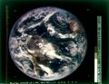 NASA's first color photo (digital image mosaic) of Earth, imaged in 1967 by ATS-3, was used as the cover of Whole Earth Catalog's first edition.
 -
Time-lapse footage of the Earth captured by the NASA ATS III satellite in 1967.
-
This ATS-3 Satellite shows Hurricane Camille (left) and Hurricane Debbie (right) on August 17, 1969
-
Hurricane Agnes made landfall in Florida on June 18, 1972, seen here from the ATS-3 satellite before moving ashore.
-
The April 3–4, 1974, "Super Outbreak" is the second-largest outbreak of tornadoes in the U.S. on record, and holds the record for the most F5 tornadoes on a single day. The image seen here is from the ATS-3 satellite on the afternoon of April 3, 1974, as the outbreak was beginning.
-
 ATS-3 Ground Station Antenna


See also
- 1967 in spaceflight
- First images of Earth from space
- Applications Technology Satellite
References
- ↑ McDowell, Jonathan. "Launch Log". Jonathan's Space Page. http://planet4589.org/space/log/launchlog.txt.
- ↑ "ATS 3 Satellite details 1967-111A NORAD 3029". N2YO. January 21, 2014. http://www.n2yo.com/satellite/?s=3029.
- ↑ "ATS | Science Mission Directorate". https://science.nasa.gov/missions/ats.
- ↑ "Technology". solarstorms.org. http://www.solarstorms.org/Quote4.html.
- ↑ 5.0 5.1 5.2 Glover, Daniel R. (1997). "Chapter 6: NASA Experimental Communications Satellites, 1958–1995, SP-4217 Beyond the Ionosphere". in Butrica, Andrew J.. Beyond The Ionosphere: The Development of Satellite Communications. NASA. https://history.nasa.gov/SP-4217/ch6.htm.
- ↑ "Applications Technology Satellite Program". https://science.nasa.gov/missions/ats.
- ↑ Miller, Steven D.; Schmit, Timothy L.; Seaman, Curtis J.; Lindsey, Daniel T.; Gunshor, Mathew M.; Kohrs, Richard A.; Sumida, Yasuhiko; Hillger, Donald (Oct 1, 2016). "A Sight for Sore Eyes: The Return of True Color to Geostationary Satellites". Bulletin of the American Meteorological Society (American Meteorological Society) 97 (10): 1803–1816. doi:10.1175/bams-d-15-00154.1. ISSN 0003-0007. Bibcode: 2016BAMS...97.1803M.
- ↑ "The First Color Images of the Earth from Space". Mar 13, 2019. https://www.geographyrealm.com/the-first-color-images-of-the-earth-from-space/.
- ↑ "NASA – NSSDC – Experiment – Details – Multicolor Spin-Scan Cloudcover Camera (MSSCC)". NASA. https://nssdc.gsfc.nasa.gov/nmc/experiment/display.action?id=1967-111A-01.
- ↑ Pae, Peter, "Satellites' Longevity Limits Sales", Los Angeles Times, December 1, 2008, p. C1.
External links
 |  |


.jpg)
.jpg)
.jpg)
.jpg)