Place:Shahr-e Kord
Shahr-e Kord Persian: شهركرد Ancient names: Dezh Gord, Deh Kord | |
|---|---|
City | |
.jpg) Panoramic view of Shahr-e Kord in 2013 | |
| Nicknames: The City of Kindness, Bam-e Iran (Roof of Iran) | |
 Shahr-e Kord | |
| Coordinates: [ ⚑ ] : 32°19′56″N 50°51′23″E / 32.33222°N 50.85639°E[1][2] | |
| Country | Iran |
| Province | Chaharmahal and Bakhtiari |
| County | Shahrekord |
| District | Central |
| Elevation | 2,070 m (6,790 ft) |
| Population (2016)[3] | |
| • Total | 190,441 |
| Time zone | UTC+3:30 (IRST) |
Shahr-e Kord (Persian: شهركرد)[lower-alpha 1] is a city in the Central District of Shahrekord County, Chaharmahal and Bakhtiari province, Iran, serving as capital of the province, the county, and the district.[5] It is the largest city in the province, and is 90 km away from Iran's third largest city, Isfahan.
Name
According to the Historical Dictionary of the Kurds, the city was originally known as Deh-e Kord. ("deh" meaning "village") In 1935, the name was changed to Shahr-e Kord ("shahr" meaning city) to reflect the growth of the city and its population.[6] The name "Deh Kurd" is also visible in the Kurdistan et groupements Kurdes isolés.[7]
Coins have been found in Shahr-e Kord dating back to the Sasanian and Parthian era.[8]
Demographics
Language
The linguistic composition of the city:[9]
Population
At the time of the 2006 National Census, the city's population was 126,746 in 31,977 households.[10] The following census in 2011 counted 159,775 people in 44,081 households.[11] The 2016 census measured the population of the city as 190,441 people in 55,492 households.[3]
Geography
Location
Shahr-e Kord is located about 90 km (56 mi) southwest of Isfahan and 512 km (318 mi) of Tehran. It is topographically situated in the north of the Zagros Mountains. Being located 2,070 m (6,790 ft) above sea level, Shahr-e Kord is the most elevated among the centers of the provinces of Iran, known as the Roof of Iran.[12]
Climate
Shahr-e Kord has a hot-summer mediterranean continental climate (Köppen: Dsa, Trewartha: Dc), with hot summer days, cool summer nights, cold winter days, and freezing winter nights. The annual average temperature in Shahr-e Kord is about 11.4°C (52.5°F). The absolute minimum temperature recorded in Shahr-e Kord since the start of keeping records has been −32.4 °C (−26.3 °F) on 29 December 2004, while the highest maximum temperature ever recorded was 42.0 °C (107.6 °F) on 15 July 1977.[13] January is the coldest month and July is the hottest month. Although the humidity level is moderate or high in winter, the amount of rainfall is close to zero in planting seasons, except for April and May.
Script error: No such module "weather box".
Economy
- Barfab Company manufactures home appliances including evaporative coolers, gas/kerosene/electric water heaters, gas space heaters, refrigerator - freezers, and twin-tub washing machines. Hiring about 1400 people within the firm, Barfab is the biggest private unit in the province.
- Shahrekord (Zagros) Cement Co is located in the center of the mountain range of Zagros, 35 km away from Shahr-e Kord (Zagros) city.
- Shahr-e Kord (Zagros) Zagros Steel Company engages in the manufacturing of cast iron.
- Farokh Shahr Steel Industries is a tinplate producer. It is located 10 km away from Shahr-e Kord city.
- Shahrekord (Zagros) Carbon Dioxide Corp. is the largest producer of CO
2 and dry ice in Iran. - Shahrekord (Zagros) Textile Industries Co, founded in Shahr-e Kord in 1991, is a fabric retail store which specializes in clothing fabrics, polyester viscose, and black Chador.
- PAK PAY CO , founded in Shahr-e Kord in 1991, is a dairy factory which produces pasteurized milk, flavored milk, cheese, and yogurt. In 1996, Pak Dairy Co bought approximately 99% of the company's stock.
- Photonic and Optoelectronic Research Group was founded in Shahr-e Kord in 2014. This research group is managed by Dr. Hamed Saghaei, one of the prominent researchers in this field of study. The research group focuses on design and fabrication of micro and nano-photonic devices including photonic crystal fibers and waveguides, photonic chips based on optofluidic approach, etc. This research group is supported by Islamic Azad University, Shahr-e Kord Branch.
- Energy Research Center, the research group focusing on energy and environment including renewable energy employed in building, etc. This research group is supported by Islamic Azad University, Shahr-e Kord Branch, https://shahrekord.iau.ir/energy/fa
Transportation
Shahrekord Airport is a domestic airport located to the south of the city. It currently has flights to and from two cities: Tehran and Mashhad.
Education


There are three universities in the city of Shahr-e Kord. The public and state university is Shahr-e Kord University (SKU) with 5,713 students. The other universities are Shahr-e Kord University of Medical Sciences (SKUMS) with 1,690 students and Islamic Azad University of Shahr-e Kord Branch (IAUSHK) with 7,400 students.
Sister cities
Notable people
Notable people from Shahr-e Kord include painter Arghavan Khosravi.[17]
Gallery
-
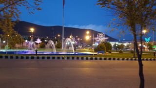
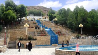 Mellat Park, Shahr-e Kord
 -
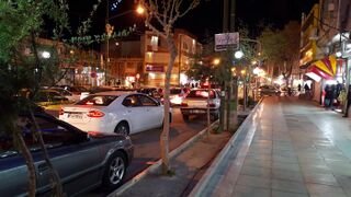 Bazaar Intersection, core of the city
 -
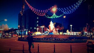 Abi Square
 -
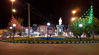 Ferdowsi Square
 -
 Imam Hossein Square
 -
 Bostane Madar


See also
Notes
References
- ↑ OpenStreetMap contributors (31 August 2024). "سر چشمه ها [Sar Cheshmehha], Shahr-e Kord, بخش مرکزی [Central District], Sharekurd County, Chaharmahal and Bakhtiyari Province, 88176-11998, Iran" (Map). OpenStreetMap (in فارسی). Retrieved 31 August 2024.
- ↑ Template:Cite Google Maps
- ↑ 3.0 3.1 "Error: no
|title=specified when using {{Cite web}}" (in fa) (Excel). https://www.amar.org.ir/Portals/0/census/1395/results/abadi/CN95_HouseholdPopulationVillage_14.xlsx. - ↑ Shahr-e Kord can be found at GEOnet Names Server, at this link, by opening the Advanced Search box, entering "-3084174" in the "Unique Feature Id" form, and clicking on "Search Database".
- ↑ Habibi, Hassan (12 September 1990). "Error: no
|title=specified when using {{Cite web}}" (in fa). وزارت کشور [Ministry of the Interior]. https://lamtakam.com/law/council_of_ministers/113039. - ↑ Gunter, Michael M. (2011). Historical Dictionary of the Kurds (2nd ed.). Scarecrow Press. p. 203. ISBN 978-0810867512.
- ↑ "Kurdistan et groupements Kurdes isolés". https://collections.lib.uwm.edu/digital/collection/agdm/id/5773.
- ↑ http://www.sh-shahrekord.ir/user/Index.jsp?SID=39&lang=Fap
- ↑ "Language distribution: Chaharmahal and Bakhtiari Province". http://iranatlas.net/index.html?module=module.language-distribution.chahar_mahal_va_bakhtiari#eyJ0IjoieCIsImkiOiI0ZjRkNzFhMjIxNDA1NDdhMWFkOWViNzU3MDBjZmY4MyIsInMiOjE2OTU1NDExNjg1NDd9.
- ↑ "Error: no
|title=specified when using {{Cite web}}" (in fa) (Excel). http://www.amar.org.ir/DesktopModules/FTPManager/upload/upload2360/newjkh/newjkh/14.xls. - ↑ "Error: no
|title=specified when using {{Cite web}}" (in fa) (Excel). https://irandataportal.syr.edu/wp-content/uploads/Chahar-Mahal-and-Bakhtiari.xls. - ↑ "About the City". https://www.sku.ac.ir/University_AboutCity.aspx.
- ↑ 13.0 13.1 "Temperature records highest in C. Station: Shahr-e kord(40798)". Iran Meteorological Organization. http://www.chaharmahalmet.ir/stat/archive/iran/chb/SHAHREKO/7.asp.
- "Temperature records lowest in C. Station: Shahr-e kord(40798)". Iran Meteorological Organization. http://www.chaharmahalmet.ir/stat/archive/iran/chb/SHAHREKO/6.asp.
- ↑ "World Meteorological Organization Climate Normals for 1991-2020: Sharekord" (CSV). NOAA. https://www.nodc.noaa.gov/archive/arc0216/0253808/2.2/data/0-data/Region-2-WMO-Normals-9120/Iran/CSV/Shahrekord_40798.csv.
- ↑ "Number of days with snow or sleet Station: Shahr-e kord(40798)". Iran Meteorological Organization. http://www.chaharmahalmet.ir/stat/archive/iran/chb/SHAHREKO/32.asp.
- ↑ "Archived copy". http://www.farsnews.ir/newstext.php?nn=13900612000453.
- ↑ Fenstermaker, Will (October 30, 2019). "Facing Duality: Arghavan Khosravi". https://bombmagazine.org/articles/facing-duality-arghavan-khosravi-interviewed/.
External links
Template:Chaharmahal and Bakhtiari Province
 |  |
