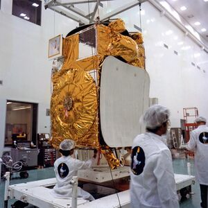
Engineering:INSAT-1D
 | |
| Mission type | Communications, Cloud Observation |
|---|---|
| Operator | INSAT |
| COSPAR ID | 1990-051A |
| SATCAT no. | 20643 |
| Mission duration | 7 years |
| Spacecraft properties | |
| Spacecraft type | INSAT-1 |
| Manufacturer | Ford Aerospace |
| Launch mass | 1,190 kilograms (2,620 lb) (Lift - off Mass)[1] |
| Dry mass | 550 kilograms (1,210 lb)[1] |
| Power | 1000 W (Solar array);[1] Nominal Power: 1200.0 W [2] |
| Start of mission | |
| Launch date | June 12, 1990, 05:52:00 UTC [3][4] |
| Rocket | Delta 4925[5] |
| Launch site | Cape Canaveral Air Force Station LC-17B |
| Contractor | NASA |
| Deployment date | UTC |
| End of mission | |
| Disposal | Decommissioned (mission life over)[1] |
| Deactivated | 14 May 2002 |
| Orbital parameters | |
| Reference system | Geocentric |
| Regime | Geostationary |
| Longitude | 83° east [1] |
| Semi-major axis | 42,164.88 kilometres (26,200.04 mi) |
| Eccentricity | 0.0012393 |
| Perigee altitude | 35,741 kilometres (22,208 mi) |
| Apogee altitude | 35,846 kilometres (22,274 mi) |
| Inclination | 14.30 degrees[6] |
| Period | 23.93 hours |
| Epoch | 14 November 2013, 15:52:38 UTC[6] |
INSAT-1D was 4th and the concluding multipurpose geostationary satellite of the INSAT-1 (first-generation seven-year responsibility for the operation of the INSAT space segment.[7]
But the success of this launch meant a lot to India - a country that was setting up its national computer networks. Relying on a lot of communication circuits, microwave, coaxial, and fibre-optic telecommunication links throughout the country causes a huge problem; and thus the Indian Space Research Organisation (ISRO) planned at the start of the INSAT-1 series to always have at least two satellites in space to meet the increasing demand of telecommunication links for India's civilian community. INSAT-1A and INSAT-1C had already faced immature death and their plans had suffered a serious setback. Another satellite INSAT-1B, launched in 1983, exceeded its planned seven-year working life.[8]
Launch
INSAT 1D was built by Ford Aerospace (now Loral Inc) for the Indian National Satellite System.[9] Initially, the launch was scheduled for 29 June 1989. Unfortunately, 10 days before that, during launch preparation, a launchpad hoist cable broke and a crane hook fell on it damaging its C-band reflector. The fully insured satellite was repaired by Ford Aerospace at a reported cost of $10 million. But that mishap was followed by solar panel damage of cost $150,000 suffered during the 1989 San Francisco earthquake. The satellite was finally launched from Launch Complex 17B, Cape Canaveral Space Force Station, United States with the Delta 2 rocket. It had a 7-year life expectancy.[2]
Structure
The satellite was box-shaped, measuring 2.18 × 1.55 × 1.42 metres (7.2 × 5.1 × 4.7 ft).[2][1] A solar sail and 11.5-square-metre (124 sq ft) solar panel extended overall length to 19.4 m (64 ft) when deployed. It was housed 12 C-band transponders for telephone and data communications and two S-band transponders for direct broadcast service. A very high-resolution radiometer (VHRR) was installed for meteorological imagery for long-term weather forecasting, storm warning and resource management.[1]
INSAT-1D played a vital role in replacing INSAT-1B. Moreover, at that moment India already had hired Arabsat's 12 transponders at high cost (the rate of $800,000 per transponder per year). Failure of the 1D mission would compel the government to hire more transponders.[8]
See also
- Indian Space Research Organisation
- INSAT-1A
- INSAT-1B
- INSAT-1C
- 1990 in spaceflight
- List of Indian satellites
References
- ↑ 1.0 1.1 1.2 1.3 1.4 1.5 1.6 "ISRO Satellite Centre, Bengaluru - SALIENT FEATURES OF INSAT-1D". http://www.isac.gov.in/communication/html/insat-1d.jsp.
- ↑ 2.0 2.1 2.2 "NASA-INSAT 1D (NSSDCA/COSPAR ID: 1990-051A)". NASA. https://nssdc.gsfc.nasa.gov/nmc/spacecraft/display.action?id=1990-051A.
- ↑ "Archived ISRO Website". http://www.isro.org/satellites/insat-1d.aspx.
- ↑ McDowell, Jonathan. "Launch Log". Jonathan's Space Page. http://planet4589.org/space/log/launchlog.txt.
- ↑ "Department of Space Indian Space Research Organization - INSAT-1D". dos.gov.in. 12 June 1990. http://dos.gov.in/hi/node/235.
- ↑ 6.0 6.1 "INSAT 1B Satellite details 1983-089B NORAD 14318". N2YO. 14 November 2013. http://www.n2yo.com/satellite/?s=14318.
- ↑ "INSAT-2". eoPortal. https://directory.eoportal.org/web/eoportal/satellite-missions/i/insat-2.
- ↑ 8.0 8.1 "Filling a crucial gap; The satellite will improve vital communication links.". Amarnath K. Mknon, India Today. July 15, 1990. http://indiatoday.intoday.in/story/insat-id-satellite-to-improve-vital-communication-links/1/315332.html.
- ↑ Krebs, Gunter. "Insat 1A, 1B, 1C, 1D". Gunter's Space Page. http://space.skyrocket.de/doc_sdat/insat-1a.htm.
Second-generation the Second-generation the External links
- ISRO Satellite Centre, Bengaluru - SALIENT FEATURES OF INSAT-1D
- ISRO - INSAT-!D
- NASA Space Science Data Coordinate Archive
 |


